Minecraft: Creating a map of Great Britain
Joseph Braybook, one of our summer interns, spent some of his time building a Minecraft world using OS OpenData products.
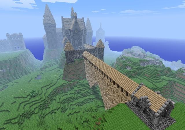
An avid fan of the Minecraft video game, he suggested building a Minecraft world using OS OpenData products. In just two weeks Joe created a Minecraft world representing over 224,000 square kilometres of Great Britain* and now we’re making it available so you can download and explore!
If you’re not one of Minecraft’s 33 million active users, it’s a game set in virtual 3D worlds made up of cubes of different materials. Players build shelters, make things from raw materials and fend off a variety of monsters. Minecraft worlds are often computer generated, though dedicated players have also created meticulous recreations of real and imagined environments such as Hogwarts castle.
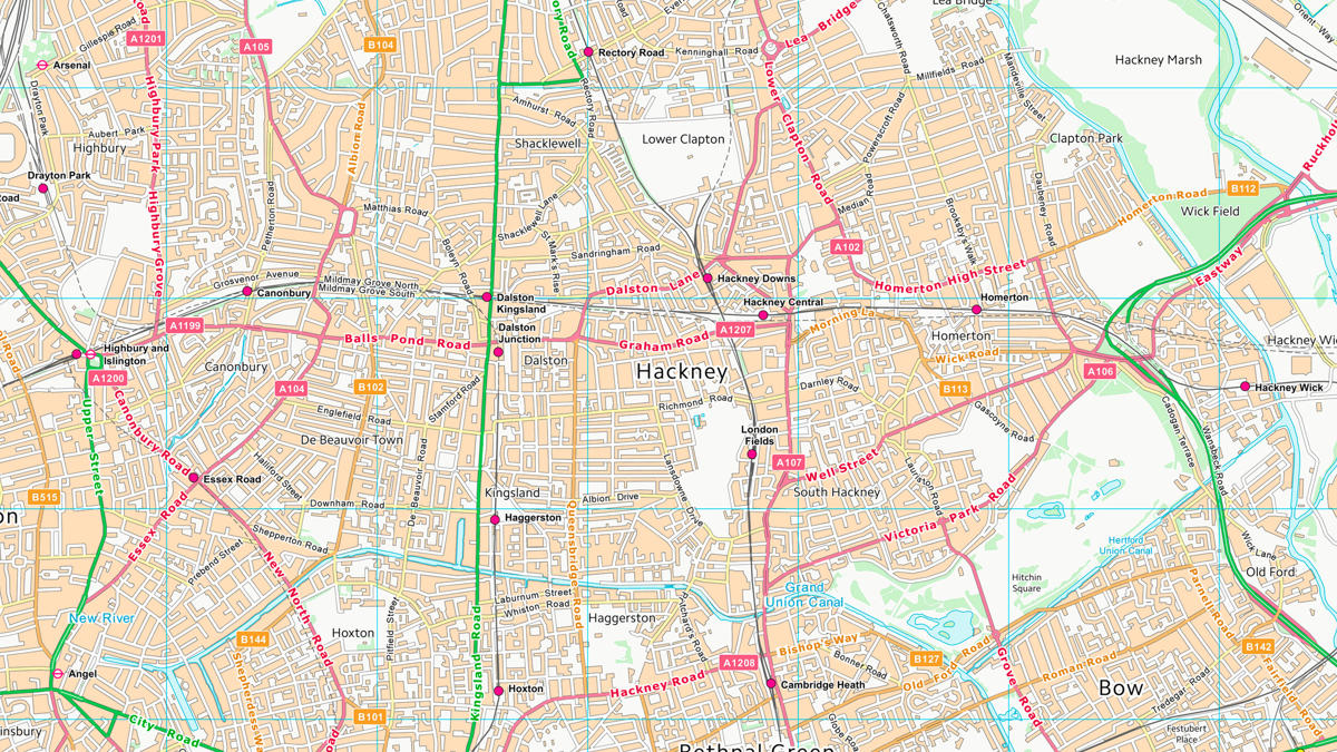
We used two of Ordnance Survey’s digital map products that are freely available as OS OpenData for anyone to use, to build the world:
- OS Terrain 50: A three-dimensional model of the bare earth surface known as a Digital Terrain Model (DTM). The product is delivered as a grid with a resolution of 50 metres. We used this product to generate the Minecraft GB terrain.
- OS VectorMap District: A mid-scale contextual or backdrop map product. We used the raster version, extracting surface features – for example water, woodland and roads – based on pixel colours and densities. We used this information to modify the material of individual blocks.
The resulting world consists of over 22 billion blocks – we think this may be the largest Minecraft ever built based on real-world data!
If you would like to find out more about the Minecraft build map or download it to see the possibilities you could create using OS OpenData, check out our website for more details and a link to the download. If the Minecraft map inspires you to create more worlds in Minecraft, use the Minecraft map in your school as a geography resource, to use our OS OpenData to create new services, or anything similar – let us know on the blog.
You can also read about this on the BBC website: http://www.bbc.co.uk/news/technology-24177844
*We are the national mapping authority for Great Britain, so our data includes mainland Great Britain and surrounding islands but does not include Northern Ireland, Ireland, Isle of Man or Channel Islands as these all have their own mapping authorities or services.
The Minecraft map is no longer available for download.
Sharing the latest news about OS. We can license you to use OS maps in print, online and film format. For more information and resources for journalists, bloggers and media professionals, email pressoffice@os.uk or call 023 8005 5565.
Products and solutions featured in this blog
OS Terrain 50
OS Terrain® 50 is an open height dataset of contours with spot heights, breaklines, coastline, lakes, ridges and formlines for Great Britain.
OS VectorMap District
OS VectorMap® District is an open basemap to overlay and visualise your own information on.