OSGM15 - the geoid for Britain
Learn how positions and heights surveyed by our surveyors with GPS make it onto our maps
Coordinate systems worldwide
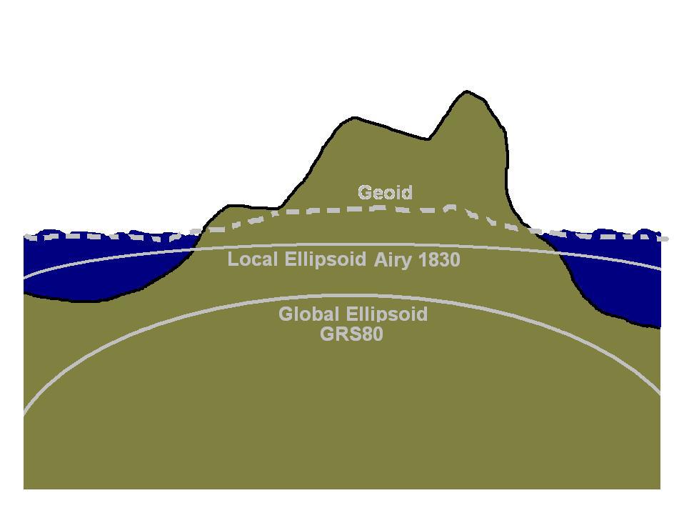
All positioning and surveying, not just that from GPS, has to take place on a mathematically simplified model of the surface of the Earth. The surface that the model attempts to emulate is called the geoid. The geoid is a complex concept, but can be imagined as a hypothetical surface that would be formed if the water in the oceans, close to mean sea level, continued under the land and was only influenced by Earth’s gravity field. This surface is one we already refer to without perhaps thinking about it – we say oceans have “depth” (below the arbitrary zero height surface) and mountains have “height” (above the surface). The geoid is a complex shape since it is influenced by varying Earth gravity. It is too complex to act as our surface for the calculations involved in positioning and surveying, so we need to fit a simple model shape to it.
The usual practice is for the model surface to be an ellipsoid that best fits the geoid. An ellipsoid is a sphere that’s squashed down a little bit at the poles – this is a better approximation of the shape of the Earth than a sphere. The chosen ellipsoid can be sized and positioned to just fit the geoid in one particular area, such as for mapping a single country like Great Britain, or to achieve an average fit for the whole Earth.
The model also needs to define a “Datum” or (the more modern term) “Coordinate Reference System”. This is a theoretical concept that adopts certain parameters required to make the model match the Earth, such as that zero degrees longitude passes close to Greenwich. Often a height datum, related to observations of mean sea level, is also adopted by each country since, as we have said, this is very close to the geoid surface and is a natural way to think about height. The coordinate reference system and mean sea level height need to be turned from theoretical concepts into something “real” available to users – they need to be “realised”. This is done by adopting a set of coordinates and heights for fixed points across the area being mapped so that they form a frame work within which all positioning and mapping can take place. This is the “Coordinate Reference Frame”.
Britain’s coordinate system
All mapping in Great Britain is in the OSGB36 National Grid coordinate reference system, and heights are above mean sea level defined at Newlyn in Cornwall – Ordnance Datum Newlyn (ODN). OSGB36 is what might be termed a “traditional” datum. The “36” refers to 1936 when the coordinate reference system concepts were designed and adopted. It uses an ellipsoid, known as Airy 1830, that’s fitted close to the geoid just across the area of GB. It was realised by the coordinates of the triangulation network (coordinate reference frame) which includes the thousands of very familiar trig pillars. ODN was realised by the heights of thousands of benchmarks across the country.
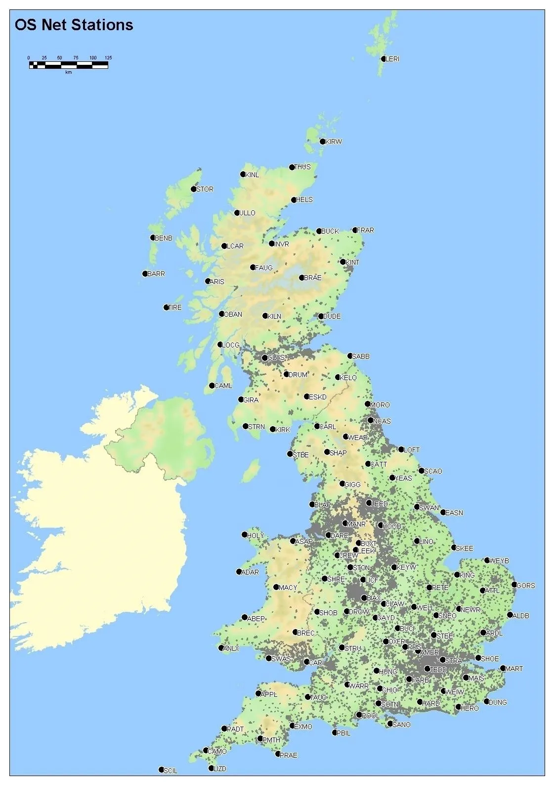
In contrast to OSGB36, GPS uses a global system called WGS84 and its ellipsoid, known as GRS80, achieves an average fit to the geoid across the whole Earth. There is no mean sea level height datum – heights are measured above the ellipsoid surface. As mentioned in our Is Britain on the move? blog last month, in Europe we have a high accuracy version of WGS84 called ETRS89. In GB ETRS89 is realised through the OS Net permanent GPS stations.
All these different ways of modelling the Earth mean our positions don’t easily fit together, meaning the coordinates of the same physical point on the Earth can be different depending on what system they are in. Sometimes a simple equation can be used to transform coordinates from one system to another system, but more often than not the difference varies from place to place, so the transformation has to be more complex. This is the case in Britain and we have a transformation model between ETRS89 and OSGB36 called OSTN15 and a separate model for ETRS89 height to ODN called OSGM15. When our surveyors are out using OS Net to update our maps their GPS coordinates are transformed to OSGB36 and ODN through OSTN15/OSGM15.
So what’s this got to do with growing hills?
We have recently improved the OS Net coordinates and the transformation models – OSTN15 used to be OSTN02 and OSGM15 used to be OSGM02. This has resulted in a small average shift in coordinates of less than 1cm, but the height has changed by more than this – about 2.5 cm on average on mainland Britain. So although Calf Top, the hill in the news recently, was accurately surveyed in 2010 as just being short of mountain status, the new models now mean the height sneaks into mountain territory (just)!
More information
If you’d like technical background to the coordinate and transformation changes read this article on our website (PDF).
The VERY technically minded can also read the 45 pages of A guide to coordinate systems in Great Britain (PDF).
Anything else? Ask on the blog or drop us an email to GeodeticEnquiries@os.uk.
Sharing the latest news about OS. We can license you to use OS maps in print, online and film format. For more information and resources for journalists, bloggers and media professionals, email pressoffice@os.uk or call 023 8005 5565.