Discover the best parts of Dartmoor National Park with this guide
Dartmoor is not just special for its internationally important wildlife and habitats – it is also renowned for its human heritage. Discover just a few of the things that make Dartmoor special and which can be seen by anyone with an urge to get to know this unique landscape.
In August and September, Dartmoor becomes awash with purple and yellow: the colours of heather and western gorse. The heather and western gorse community is unique to the northern Atlantic fringe of Europe. There are three species of heather on Dartmoor: common heather, bell heather and cross-leaved heath. See if you can spot them all!
The best places to see this beautiful colour festival are around Haytor near Bovey Tracey; Headland Warren (between Moretonhampstead and Postbridge); and East Dartmoor Woods and Heaths (Natural England National Nature Reserve; between Bovey Tracey and Manaton).
Sphagnum moss is most noticeable in winter time when other vegetation has died down. You can find it in the wetter areas of Dartmoor uplands. Bog mosses are indicators of a healthy mire or blanket bog community and one of the major peat formers and as such have shaped the landscape of Dartmoor as we see it today.
Dartmoor contains the largest number of prehistoric ceremonial sites in north-west Europe. Stone rows are one of the most enigmatic and prolific; there are over seventy five on the moor. In fact 60% of all the stone rows in England are found on Dartmoor including the longest stone row in the world which is on Stallmoor.


Longhouses date from around 1250AD. As their name suggests, they are long buildings with opposing entrances and are aligned downslope. They were home to both humans and animals. The remains of longhouses at Hutholes and Houndtor lie fairly close to Widecombe-in-the-Moor.
Over the centuries people have exploited Dartmoor’s natural resources including tin, granite and peat but there have also been some more curious enterprises including an iceworks established in 1875 near Sourton Tor and a gunpowder factory at Powdermills near Postbridge. Most of Dartmoor’s streams bear evidence of tin streaming (the extraction of tin from stream beds) and the remains of large tin mining operations can be seen at Aylesbarrow, south of Princetown and Vitifer, near Postbridge. The gunpowder factory is located near Powdermills, Postbridge and the iceworks remains lie north east of Sourton Tor, on north west Dartmoor. The remains of a naptha works (extracting fuel from peat) can be seen near Avon Dam, South Brent.
Devonport Leat Image: DNPA
Many of these industries relied on water as a source of power and artificial watercourses (leats) were constructed to carry water over great distances to power mills which drove early industry on Dartmoor. Leats were also used to transport drinking water. The building of reservoirs on Dartmoor began in the mid 1800s and today Dartmoor provides 45% of South West Water’s daily supply of 429 million litres. The land around these large areas of water is full of history. The remains of Drake’s leat can still be seen on Roborough Down (Ordnance Survey grid reference SX 516 652) but many leats still carry water and some still directly supply drinking water for Dartmoor farms. Devonport leat (Ordnance Survey grid reference SX 606 705) near Princetown flows into Burrator reservoir and can be visited on a great walk from Princetown. Drake’s Leat was constructed in the late 16th century to supply Plymouth with water. In 1581, Sir Francis Drake became Mayor of Plymouth and it was at this time that the idea for the leat was considered. It was one of the first municipal water supplies in the country. The construction of Burrator reservoir replaced the use of this leat.
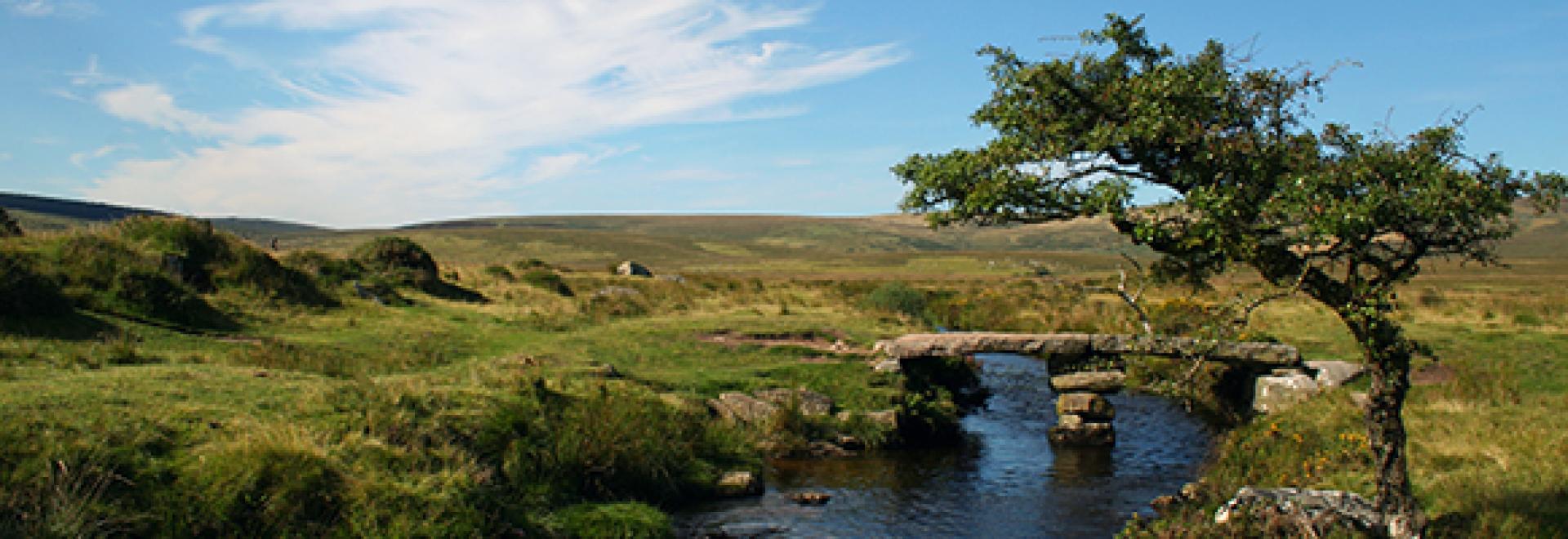
Clapper bridges span many a Dartmoor river. Although Postbridge clapper is the largest there are many others in more remote locations which are well worth a visit. Although they may well have existed from prehistoric times the earliest evidence is from the medieval period. The famous Postbridge Clapper lies just downstream of the main road bridge on the B3212 in Postbridge. Smaller but no less picturesque bridges like the one over the Teign near Batworthy (Ordnance Survey grid reference SX 654 870) help keep your feet dry on a fascinating walk out to Scorhill stone circle.


One could not write about things to see on Dartmoor without mentioning tors. Standing at 572 metres above sea level Fur Tor is not the highest of Dartmoor’s tors but it is certainly the most remote. It sits in the centre of the northern moor, west of Cut Hill. A walk to this wonderful spot is only for those who have the ability to navigate with a map and compass and the fitness to get there and back. Those who do venture out this far will be rewarded with a real feeling of Dartmoor’s wildness and some stunning views.
Many of Dartmoor’s tors are easily accessible form the road but Fur Tor can only be reached by a long walk across open moorland. It can be approached from any compass direction and is situated at Ordnance Survey Grid reference SX 587 830
Fur Tor in Dartmoor National Park Image: DNPA
To find out more about what to see and where to visit on Dartmoor call in to a National Park Visitor Centre or visit www.dartmoor.gov.uk.