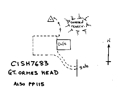
Overview
- Type of mark
- Pillar
- Flush bracket
- S1627
- Grid reference
- SH767833
- Access to mark
- foot
- Keys required
- No
- On Landranger sheet
- 115
Click to buy - On Explorer sheet
- 262
Click to buy - Permission required
- Yes
Coordinates of this station
ETRS89 Cartesian
- X
- 3808590.9878
- Y
- -256456.2817
- Z
- 5092938.9537
ETRS89 Geodetic
- Latitude
- N 53 ° 19' 57.12824"
- Longitude
- W 3 ° 51' 8.166159"
- Ellipsoid height
- 261.261
National Grid (Transformed by OSTN15/OSGM15)
- Eastings
- 276750.807
- Northings
- 383334.135
- Height
- 207.158
NB: If 'permission required' is Yes at top of this form, the land owner or agent's permission must be obtained before accessing the mark.