Simplifying geospatial language to expand its impact
By Magdalena Low (Managing Geospatial Consultant), Steve Attewell (UX Practice Lead), and Mark Stileman (Senior Propositions Manager) at OS
As Great Britain’s national mapping service, Ordnance Survey (OS) was pleased to contribute to this year’s GEO Business showcase in London. It's an annual opportunity to demonstrate how location data and geospatial technology are being used to improve planning, operations and innovation across industries.
This year, OS had a lot to showcase with several talks from experts across the business, presenting on various projects and topics. On behalf of the wider team, Magdalena hosted a demonstration on the importance of simplifying geospatial language: a means of making our data easier to discover, understand, and apply, whatever the skillset and experience of a user.
We are OS, after all. Our role is not only to provide authoritative geospatial data, but to help more people use it with confidence, whether they're a geospatial specialist, a policy professional, senior stakeholders making strategic decisions, level a data scientist, a business analyst, or - as we're seeing increasingly in this sector - an AI-enabled system. We want more people, businesses, organisations to join this sector, we want geography to remain a key curriculum, because we know what the power of location data can achieve.
And so, we explored ways of making it even more accessible.
Same place, so many words
A simple object in the real world can be described in many ways, depending on personal knowledge and context. What someone calls a house could also be called a building, home, property, roofed structure or shelter. Each description can be valid, depending on context.
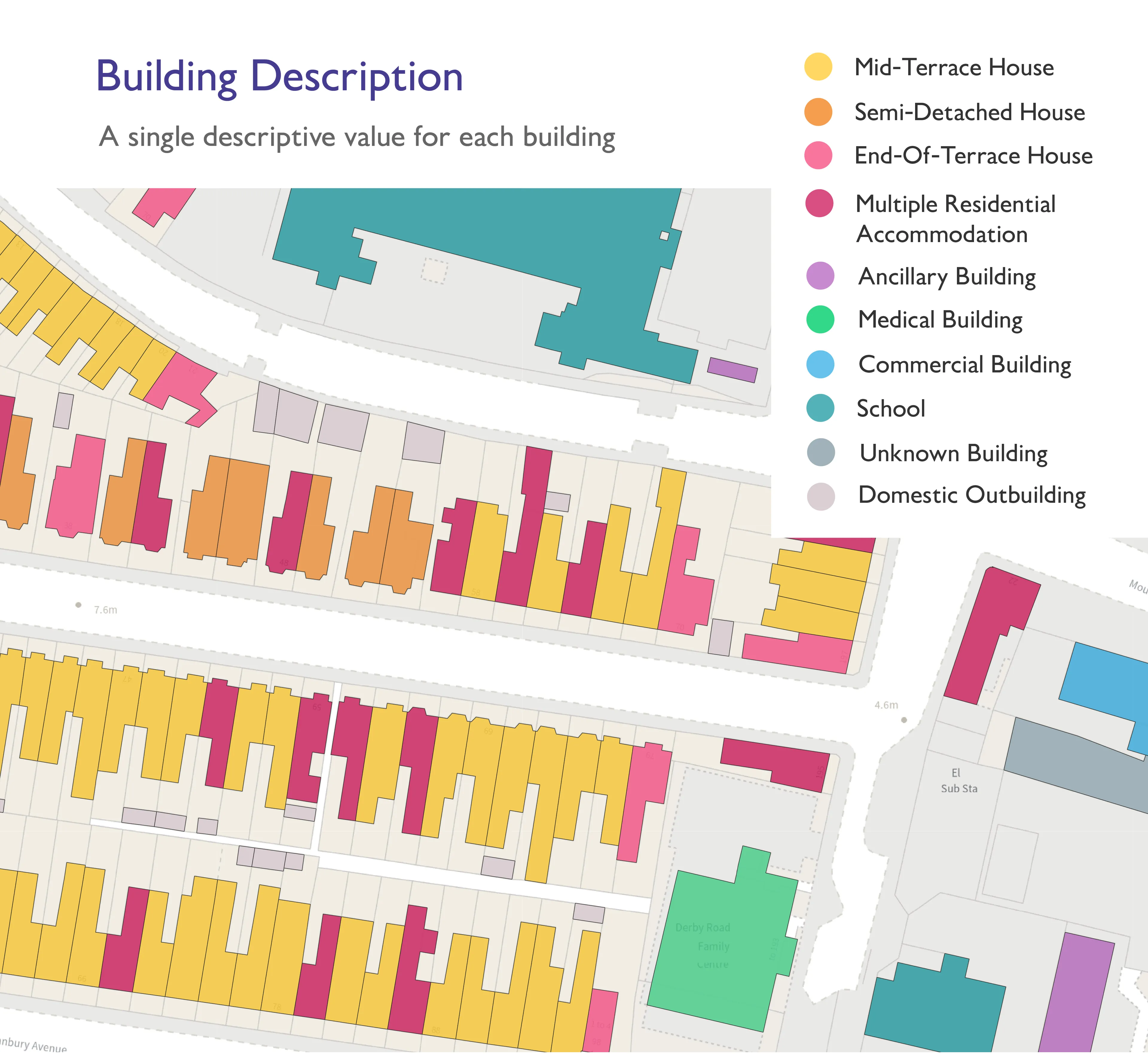
But when those real-world objects become data, language has to do more than describe. It has to help people find, interpret and use information correctly.
This is one of the central challenges in geospatial data. The world is complex, and the way we represent it in data can be equally complex. OS data underpins national policy, public services and business decisions, but some of its value can be hidden behind specialist terminology, product names, schemas, and assumptions that are familiar to experts but less obvious to new users or non-technical experts. The richness and sophistication of that data can also be complex and daunting.
In addition, a customer may not ask, “Which product contains the relevant feature classification?”
They are more likely to ask, “Where are the sports facilities near me?” or “Can this help with flood defences?” or “Can this model insurance risk?”
Those are real-world questions. Answering them often requires several datasets, a clear method, and expert judgement.
It’s therefore our responsibility to label our data, describe it in a way that makes sense, and make it easier to understand.
Testing how people look for data
To explore this, OS carried out structured user research into how people naturally group, name, and search for geospatial data.
In an initial card-sorting exercise, 60 colleagues arranged cards representing OS products into groups that felt logical to them. The research deliberately included people from non-geospatial functions, without detailed knowledge of OS products, to reduce the “curse of knowledge,” the tendency for experts to assume that specialist terms are more widely understood than they are.
The results showed that familiarity matters. People with deeper knowledge of OS data often created more detailed and nuanced groupings. Those with less specialist knowledge grouped information differently, revealing patterns that were not always aligned with existing product structures.
OS then used tree testing to validate potential category labels with non-geospatial professionals to explore whether those categories help people find things successfully. Participants were asked where they would expect to find specific types of information, such as postcode data, cycle routes, authority boundaries, hill heights or land used for farming.
The evidence showed that user-derived groupings significantly improved findability compared with existing terminology. In further blind testing, refreshed categories almost doubled successful discovery, increasing correct results from 37.6% to 76.3%.
This is in no way about “dumbing down” geospatial data. It is about reducing ambiguity in the discovery. Clearer language helps more people get to the right data faster, while still preserving the richness and authority of the underlying information.
Finding products and answering questions
This matters even more as AI changes how people discover and use data. Historically, organisations have helped customers find data through user design: websites, product pages, metadata, categories, and so on. Those things remain important.
But as technologies develop, and new behaviours emerge with increased usage and sophistication of AI, we are starting to see new, different demands. Many users may not browse a catalogue or any websites at all, they may ask a question through a chat interface, use an embedded AI tool, or rely on another system to search for relevant data automatically.
That changes the challenge. It is no longer only: “Can a human find the right product page?” It becomes: “Can a human and AI understand what OS data exists, what it means, and how it can be used appropriately?”
This is where simplified language, consistent categories, and clear definitions become more than just a website improvement. They become part of the foundation for AI-ready data access.
Large language models are powerful because they work well with human language. But they still need trusted structure, rules, definitions and guidance. A user may ask:
- “Homes at risk of flooding” which may require buildings, addresses, terrain, water features, land cover and historical flood data.
- “Good places for solar panels” may require building geometry, roof aspect, height, shading, and energy information.
- “Insurance risk” may need property type, environmental context, proximity to hazards, access, and exposure.
The hard part is translating human language into data logic. Real world concepts rarely map neatly to a single data field.
Building a trusted semantic layer
One way to bridge this gap is through a semantic layer, a trusted connection between human language and data structures. A semantic layer explains what data exists, what it means, helps map user questions to methods, and makes limitations visible.
For OS, this is where authoritative data and expert guidance come together. Providing access to data is essential, but so is helping users understand sensible methods, assumptions, and limitations. Different experts may solve the same problem in different ways. Being transparent about those choices helps customers use data responsibly.
OS is also exploring how AI-enabled approaches could make geospatial data easier to discover, access, and understand through natural language prompts, including prototype work that could allow large language models to retrieve relevant OS documentation, metadata, filtered data, and insights securely.
Expanding geospatial impact
Geospatial data has huge potential to help answer society’s most important questions. But to unlock that potential, we need to meet users where they are. That means using language that reflects real-world problems, not just internal data structures.
Simplifying geospatial is a way to expand access, improve confidence, grow the sector, and help more organisations turn trusted location data into insight. And as AI becomes part of everyday workflows, this work will become even more important.
The better we describe our data, the easier it becomes for people (and machines!) to use it effectively.
Our highly accurate geospatial data and printed maps help individuals, governments and companies to understand the world, both in Britain and overseas.
Contact us
Interested in how Ordnance Survey’s location expertise can help?