GB’s national mapping service, internationally
A showcase of how Ordnance Survey’s location expertise and collaboration has made international impacts
Press Office
Through a longstanding partnership with the Foreign, Commonwealth & Development Office (FCDO), we support UK Government priorities overseas, helping other countries’ governments and institutions to strengthen their own geospatial capability, improve resilience, and unlock economic value.
We share our expertise developed through generations of maintaining one of the world’s most trusted national geospatial frameworks, to help key stakeholders make better-informed decisions that improve lives, and create a more sustainable future for citizens.
How OS has supported four African countries
Across Africa, OS has worked in partnership with national agencies, international organisations, and programme delivery partners to address some of the most pressing challenges. Two key programmes includes FCDO’s Green Cities, Infrastructure and Energy Programme (GCIEP) and the FCDO-funded Land Facility Programme.
Countries in Africa have seen rapid growth in their urban environments, making it necessary to conduct deeper analysis into the risks that may develop as a result; such as climate change, land governance, and infrastructure planning.
From large scale capability building in Ghana and the Democratic Republic of Congo, to targeted advisory work in Mozambique and Ethiopia, these projects demonstrate the breadth of OS expertise, and the lasting, worldwide value of geospatial insight.
Building capability at scale in Ghana
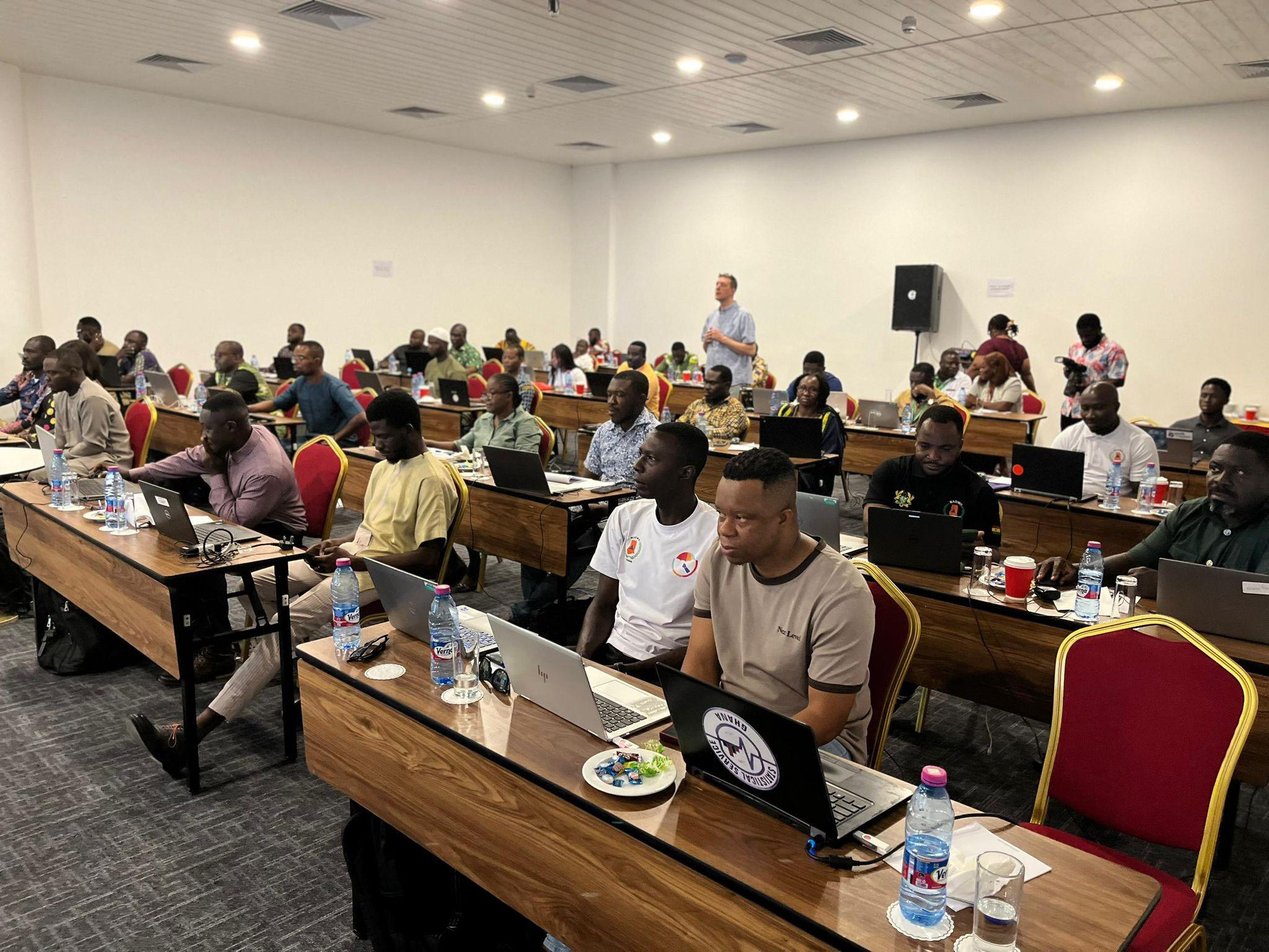
In Ghana, OS delivered an intensive, three-week geospatial training programme as part of the UK Government’s Green Cities, Infrastructure, and Energy Programme (GCIEP). The initiative was designed to strengthen the application of geospatial technologies in key institutions, and from that, upskill the technical capability of national organisations responsible for land management, climate resilience planning, and disaster response.
The training programme brought together a total of 93 participants from key institutions. OS and the British Geological Survey (BGS) helped deliver a comprehensive, modular training programme to participants from the Lands Commission, National Disaster Management Organisation (NADMO), and the British High Commission.
OS had visited Ghana in November 2025, to conduct a scoping study to understand the need of these organisations. Then, over the three weeks in Accra, March 2026, the training covered a range of geospatial tools, including QGIS, geospatial databases, coastal modelling, Earth Observation, and multi-hazard risk analysis, amounting to 435 person-days of learning.
"FCDO is grateful to British Geological Survey and Ordnance Survey teams for delivering an exceptionally strong ‘marathon’ geospatial training programme. The modular design of the programme was particularly valuable to equip participants with the knowledge and skills most tailored to their needs."
Participants enhanced their skills in tools such as QGIS and database management. When this knowledge of GIS is applied, it enables efficient workflows, enabling more efficient workflows and better-informed decision-making.
"Our team came in confident, with existing knowledge of QGIS and databases, but the experience proved that there was still much to learn. The programme has added real value, sharpening competencies, and improving overall efficiency in Lands Commission operations."
By conducting a scoping study and understanding the need of Ghana, and then applying it through building capacity, OS helped ensure that plans for climate-resilient urban development could move more quickly from concept to implementation.
Creating a national map in Ethiopia
In Ethiopia, through the UK-FCDO funded Land Facility programme, OS supported the Space Science and Geospatial Institute (SSGI) in conducting a feasibility study that considered how Automatic Feature Extraction (AFE) could be used to build a modern, accurate digital map and database of its land parcels, known as a ‘cadastre.’
A cadastre is a comprehensive government data set that records the ownership, boundaries, dimensions, and value of land parcels within a country. Investment in the form of land and property development can encounter significant delays and expense when trying to discern what land is or isn’t owned, and by whom; so the creation of an accurate cadastre forms a critical part of SSGI’s larger mission to modernise geospatial infrastructure and improve land administration systems.
Over the course of five months, OS experts collaborated with SSGI to review the country’s existing data, skills, and technology. OS contributed its own expertise in mapping standards, data management and system design.
The use of artificial intelligence (AI) and AFE were at the forefront of this project; the key outcome being whether use of AFE could create the cadastre. SSGI could accelerate it data digitisation by adopting AFE – using aerial imagery and trained models, to identify and classify features, generating digital vectors for parcels and buildings. Adapting AI into its processes would optimise efficiency, and enable the SSGI to adhere to its mandate.
This collaboration proved critical for a country experiencing rapid population growth and urban expansion, where accurate land information informs everything from infrastructure development to tenure security.
By helping lay the foundations for more reliable, accessible, and up-to-date geospatial information, through strengthening institutional capability and introducing best practice approaches, OS helped enable more effective governance and sustainable development outcomes.
Unlocking land value in Mozambique
In Mozambique, OS provided a similar service as in Ethiopia: advising on the design of a land cadastre for the cities of Pemba and Nacala.
The fundamental challenge was a lack of accurate, consistent land parcel mapping in these key cities. Without reliable parcel data linked to land ownership, taxation processes are manual and inefficient.
Working with the GCIEP Alliance (a delivery partnership including organisations such as PwC and Adam Smith International), OS advised on an approach to creating a modern land cadastre that would improve revenue generation.
OS drew on its own experience in Great Britain, to advise on establishing the foundations of a scalable, sustainable system. With OS’s assistance, municipalities have a means to improve land administration, increase revenue collection, and support future urban development.
The work was completed under the Green Cities, Infrastructure, and Energy Programme.
Enabling climate resilience in Kinshasa
OS contributed to the development of a new geospatial platform supporting climate resilience, and emergency preparation, in the city of Kinshasa – the capital city of the Democratic Republic of Congo.
Kinshasa is one of the fastest-growing cities in the world, with more than 17 million residents. It faces significant challenges from this rapid and unregulated urban growth, such as socio-economic inequalities, complex terrain, and limited resources. It is also increasingly vulnerable to climate-related disasters and severe weather events, such as intense rainfall and gully erosion.
As one of Africa’s fastest-growing cities, access to reliable, integrated geospatial information is essential for monitoring and managing its development.
OS, in collaboration with the BGS, worked with the City of Kinshasa to create a spatial platform that would enable planners, policymakers, and emergency responders to better understand and mitigate the risks posed by climate change and improve emergency preparedness.
OS’s role focused on helping shape the platform to ensure it is practical, user-friendly, and capable of delivering long-term value. OS experts also showcased the art of the possible, by collecting all of the data and setting up the web platform using Esri’s Web Builder.
By enabling better decision-making, the initiative supports more resilient infrastructure planning and improved outcomes for communities.
Delivered through the UK’s Green Cities and Infrastructure Programme, the platform brings together data and tools to help city stakeholders better understand environmental risks and plan accordingly.
A legacy of geospatial expertise
Across all four initiatives, OS has helped share the advantages of geospatial capability; to unlock better decisions, stronger institutions, and more resilient places.
"It’s been a privilege to work alongside partners internationally, sharing our expertise and learning from their local knowledge. We’re proud to have supported others in realising the value of location data, and apply it to their most pressing challenges. We leave a legacy that will continue to deliver impact."
Whether through large-scale training programmes or targeted advisory support, OS has shared in its 230+years of experience to build new skills, systems, and confidence to apply location intelligence effectively.
These projects demonstrate the global relevance of accurate, trusted geospatial data – how it is fundamental to addressing some of the world’s most complex challenges.
We are proud to work with partners, other UK departments, and FCDO & TKF to deliver these projects; to provide expertise to countries who may only just be beginning their geospatial journey.
If you would like to discuss any projects outlined in this article, or a similar project of your own, please use the Contact Us form.
Sharing the latest news about OS. We can license you to use OS maps in print, online and film format. For more information and resources for journalists, bloggers and media professionals, email pressoffice@os.uk or call 023 8005 5565.
Find more news
- International government