How location data is delivering economic growth and public value across Great Britain
Economic impact of Ordnance Survey
Economic growth depends on organisations being able to make decisions quickly and with confidence. Whether delivering infrastructure, building homes, operating public services, or directing investment, progress accelerates when organisations have reliable information and a shared understanding of place. As Great Britain’s national mapping service, Ordnance Survey (OS) provides that authoritative geographic framework.
The Economic Impact Report provides an independent assessment of the economic impact of OS. It estimates that every £1 of public funding invested in OS generates £9.50 in societal benefit, demonstrating substantial value for taxpayers and the wider economy. Over the ten year period to 2030, OS’s economic impact is estimated to exceed £10 billion.
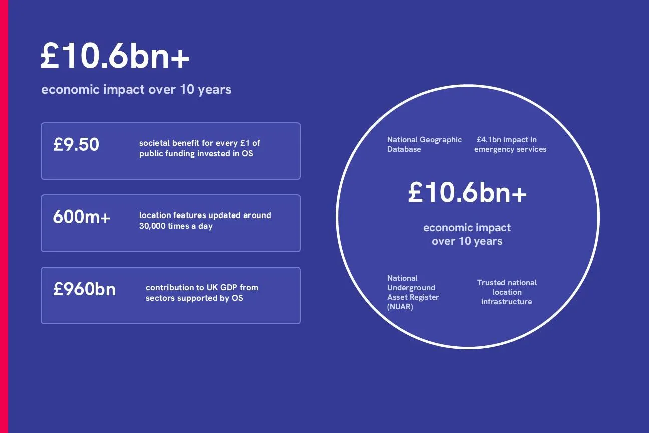
The report also finds that OS underpins sectors contributing £960 billion to UK GDP and supports public services with combined annual expenditure of more than £700 billion. Together, these represent 35% of UK GDP and 55% of total UK public spending. The benefits are visible across emergency services, housing, utilities, telecommunications and transport.
Supporting critical public services
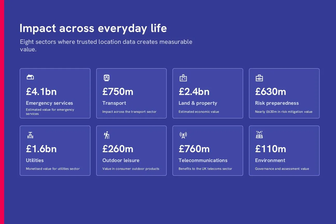
Emergency services account for the largest quantified impact, with OS data contributing an estimated £4.1 billion of value. It supports ambulance response, policing, fire and rescue operations and NHS systems by helping services locate incidents, coordinate resources and make critical decisions.
Since 2023 OS data has been supporting a life saving in-cab navigation application which has been rolled out across Ambulance Trusts in Great Britain with the aim of improving patient care and at-scene response times.
The Ambulance Radio Programme (ARP) was established by the Association of Ambulance Chief Executives (AACE) and the Department of Health and Social Care (DHSC) to deliver critical technological system improvements, providing enhanced communications between Ambulance Trusts, the NHS and other emergency responders.
Simon Marsh, former chief information officer at YAS NHS Trust and project sponsor said: “Having access to accurate and up-to-date mapping is essential to all the emergency services, and with ambulances it can make all the difference to our patient care and response times through improved navigation."
Unlocking value from land and property
OS data generates an estimated £2.4 billion in annual economic benefits across land and property. It underpins land registration, property transactions, planning and risk assessment, helping organisations identify properties accurately, reduce manual checks and complete processes more efficiently and securely.
As demand grows for faster, more connected property services, high-quality geospatial data is playing an increasingly important role across the sector. That is why the collaboration between Ordnance Survey and HM Land Registry is so significant. Together, the two organisations are working to unlock greater value from trusted public data, making property information more accessible, connected, and useful across the housing market.
"We have exciting plans to transition from traditional record keeping to actively fuelling economic growth and unlocking new opportunities across the housing sector. I am looking forward to working closely with Ordnance Survey."
Read the press release: New HMLR and OS collaboration
Making infrastructure safer and more efficient
The report estimates that OS data generates £1.6 billion of value across the utilities sector by supporting the safer and more efficient management of water, gas and electricity networks. A tangible example is the National Underground Asset Register (NUAR), which brings underground asset information together in a secure, standardised view.
Separate government analysis estimates that NUAR will deliver more than £400 million per year of economic growth through increased efficiency, fewer accidental asset strikes and reduced disruption for the public and businesses.
"NUAR is a game changing powerful extra layer for our projects, that augments what we already use. Having instant access to a standardised view of underground utilities in one map improves safety, planning, and decision-making before we get anywhere near site."
Read the full story: How NUAR supports contractors working on behalf of asset owners
Improving connectivity
OS data delivers more than £760 million in benefits to the UK telecommunications sector. Its accuracy and detail help operators identify coverage gaps, plan infrastructure, and position assets more effectively, supporting reliable connectivity across urban and rural areas.
"At Cornerstone, we have been able to strategically map the exact location of our masts to ensure even distribution and build a high-coverage telecoms grid. For radio planning purposes, precise knowledge of our sites’ locations is key to our customers, helping to maximise signal reach, minimise interference and deliver reliable connectivity across both urban and rural environments."
Supporting a better-connected road network
Across transport, OS data generates more than £750 million of economic impact. It supports infrastructure planning, route optimisation, logistics, and road maintenance, helping reduce costs, save time, and improve services.
"Ordnance Survey is the most authoritative provider of national location data, providing us with the strongest foundation for this most comprehensive model of the Strategic Road Network to date. "
A national asset delivering measurable returns
The evidence shows that trusted location data is much more than a mapping resource. It is national infrastructure that helps public services perform effectively, makes essential networks safer and more efficient, and gives organisations the confidence to invest and innovate.
From reducing emergency risk assessments to seconds, to supporting housing, connectivity, and underground infrastructure, OS data turns a shared understanding of place into tangible economic and public value. With an estimated £9.50 in societal benefit generated for every £1 of public funding invested, OS delivers a return far beyond its cost.
View the Economic Impact infographic, or read the full report below.

Content Lead
Read the full report
Find more Insights
- Location intelligence
- Economic development
- Government and public sector