National Highways making road journeys safer
The RedLine Operational Boundary that surrounds England’s Strategic Road Network is one of National Highway’s most fundamental assets, defining the limits of the organisation’s legal and maintenance responsibilities, as well as having a direct implication on scheme planning, maintenance resourcing, and legal liabilities across an estate worth over £16 billion1.
The GIS and Research Team are responsible for generating a digital representation of the Operational Boundary in support of the Highways England Framework Document for the Department for Transport (DfT).
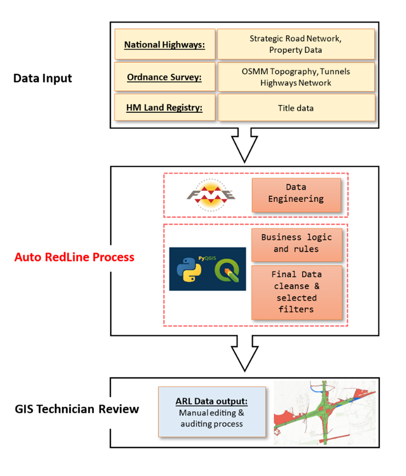
The Auto RedLine (ARL) project produces an automated ‘best guess’ of the Operational Boundary, by way of a semi-automated process combining National Highway data with a number of other sources, including Ordnance Survey and HM Land Registry to build a holistic picture of the variety and extent of the land portfolio.
The research and decisions taken using the Auto RedLine output ensures the organisation knows the extent of its land ownership and that the public highway is safely maintained for all road users. The final dataset is published as the ‘Highway Boundary RedLine’ dataset on both the Data.Gov.uk and National Highways Open Data portals.
Challenge
National Highways are ultimately liable for all land within the Operational Boundary, as well as some ownership going beyond these boundaries.
The main challenge of the Auto RedLine project was to use Geographical Information System (QGIS) and datasets to find a more intelligent approach to defining the Operational Boundary and liability across land ownership.
A key requirement was to make best use of established datasets and automated processes, reducing the amount of manual intervention. This would enable quicker decision-making, while also providing a level of assurance and clarity for end users.
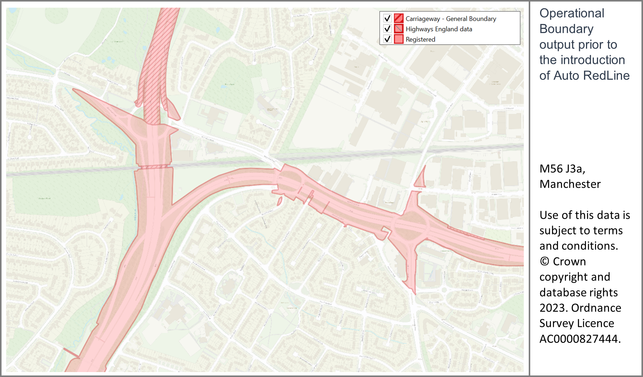
Historically, the RedLine project has required GIS technicians to digitise and evidence every piece of land within the operational boundary using multiple datasets including historical Ordnance Survey data, scanned HM Land Registry title plans, internal National Highways maintenance data, and detailed OS MasterMap Topography Layer data. This was a manual and laborious task involving many hours of detailed research.
Accelerating this process would allow the team to produce and share accurate data more quickly. This would also reduce land ownership queries from across the business, freeing up resource for other projects.
Solution
Auto RedLine (ARL) is a culmination of a series of logical rules applied to business datasets, producing an automated ‘best guess’ of the boundary.
This first step of the process involves the interrogation of several spatial datasets in GIS: Ordnance Survey MasterMap data, HM Land Registry title polygons and in-house asset datasets. The resulting dataset is then subject to a series of spatial joins and logical rules (using the Python programming language) based on distance, ownership, and other criteria.
The process runs in a PyQGIS environment to ensure replicability, allowing it to be executed on a regular basis, to pick up changes to underlying input datasets. This allows integration into existing National Highways OS MasterMap Topography Layer data update cycles. It also enables the sharing of this approach with other interested parties (for example Local Highway Authorities, devolved governments).
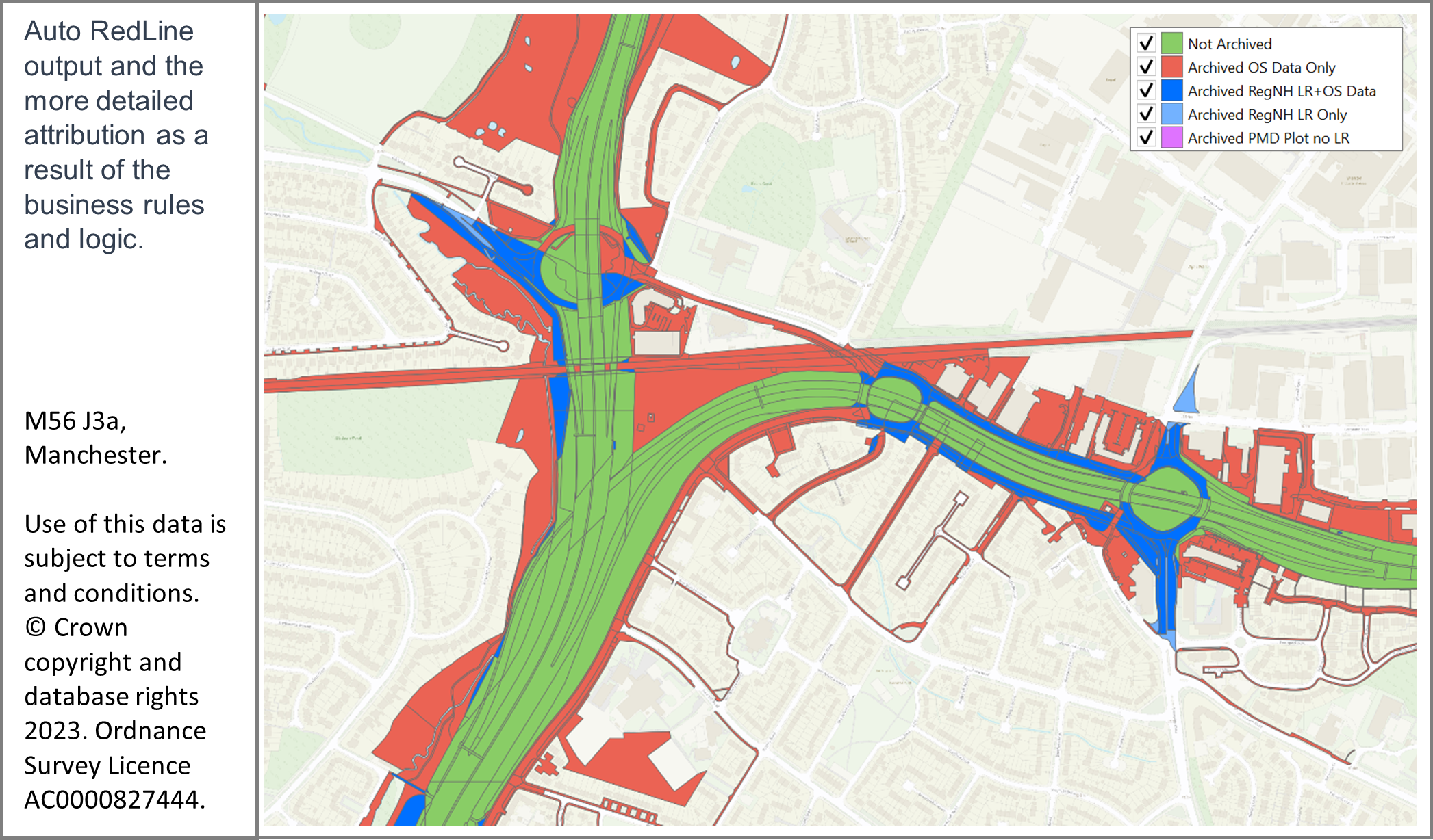
Depending on the outcome of these rules, each polygon within the ARL dataset is categorised as ‘inside’ or ‘outside’ the boundary. The dataset produced by this first step is a good approximation of our boundary – showing additional attribute categories and a more intelligent improvement based on previous manual approaches.
The second step is for the automated ARL boundary to be reviewed by a team of GIS Technicians using secondary data to make changes to the boundary. The starting point for these investigations was found in the legal orders used to exercise powers of compulsory purchase. These orders help National Highways to understand what land was bought and why. Additional secondary sources include historical mapping, title plans, asset data, satellite imagery to name a few.
Part of the investigation process includes collaboration with colleagues in Operations, who have local knowledge of the areas in question and may also have other sources of data unavailable to the GIS Technicians.
Once changes have been made these are then audited and validated to ensure that geometries are correct and appropriate evidence has been sourced and recorded in the bespoke Estates Geospatial Portfolio database. The resulting changes were submitted to HM Land Registry for registration as highway.
The benefits
Since the RedLine project began, National Highways have made great strides, by embracing technology to develop the Auto RedLine project, and building relationships with different teams across the business. These two advances have helped them improve efficiency by improving automated starting points, getting the most of local knowledge, and by improving engagement.
- Better decision making - more information allows for better decision-making as the outputs are accessible by all areas of the wider business.
- Time saving - by way of reducing technician workload and allowing more targeted research speeds up the process of digitising the highway boundary.
- Accurate data - through the added inclusion of OS MasterMap Topography Layer data, a more accurate and realistic boundary has been created for unregistered areas.
- Confidence in the data - audited sections of highway are now flagged as part of the new categorisation and provide greater confidence in the data.
- Saving money - over £1million pounds saved by reducing the need for external resource to aid data creation.
The result
With a clear and accurate picture of its total land footprint, National Highways can manage and maintain the network more easily – freeing up time, money, and resource for other projects, keeping goods and services flowing around the country, and, most importantly, making the network safer.
1 National Highways Annual Report 2023 p12:
https://nationalhighways.co.uk/media/0k1mwvsp/nh_ar23_interactive.pdf

Our highly accurate geospatial data and printed maps help individuals, governments and companies to understand the world, both in Britain and overseas.