How geospatial investment helps grow your city’s economy
The global population is growing, with much of this growth expected to occur in African cities. This presents opportunities for economic development – but it also presents challenges as municipal governments pursue sustainable and equitable development, in line with the UN’s Sustainable Development Goals.
Develop your city’s geospatial readiness
Developing your city’s geospatial readiness facilitates progress towards these goals. Investing in geospatial capabilities can be a catalyst for economic development that benefits the country as a whole. At Ordnance Survey we conduct free geospatial readiness assessments for cities, nations and organisations that can provide an investment roadmap for sustainable growth.
When a city secures the geospatial capabilities to build a base map, it sets off a chain reaction, enabling effective land administration that can supercharge your local economy.

According to the World Bank, only 30 percent of the world’s population has legally registered rights to their land and homes, meaning huge portions of the global population don’t have proper land rights. Development of a detailed, mandated digital base map is the first step towards issuing secure, reliable land rights to your city’s residents. Families thrive and are more economically active when they have government-issued land rights – as shown by a study of residents in a poor suburban area of Buenos Aires.
Property rights and permanent addresses allow citizens to secure and maintain work and apply for mortgages and loans, which can pave the way for the kind of economic development that can help to reduce the proportion of a population living in informal settlements and low quality housing in the long run. It’s this kind of socio-economic development that our mapping expertise can support.
As societies around the world seek to digitise records and expand their digital services and data economy, establishing an authoritative base map facilitates new digital services based on secure data sharing between organisations. This is critical to securing inward investment needed to grow your local economy.

Use insights from remote sensor data
Another area of Ordnance Survey’s expertise that cities around the world are drawing upon is remote sensing. OS has extensive experience in collecting and processing data from aerial photography. We also work closely with our partners to expand our automated object recognition capacity, which can provide valuable insights within the utilities, telecoms and infrastructure sectors.
Remote sensor data capture and processing can also provide insights into the impact of urban expansion on the environment. Using aerial photography from satellites and unmanned aerial vehicles (UAVs), we are helping the city government of Dubai to monitor the number and health of palm trees. By measuring the area of a tree’s crown – the aboveground vegetation as viewed from above – we can assess whether the tree is receiving enough (or indeed too much) water. As water is a scarce resource in Dubai, monitoring green spaces using automated remote sensor tech can provide other insights too.
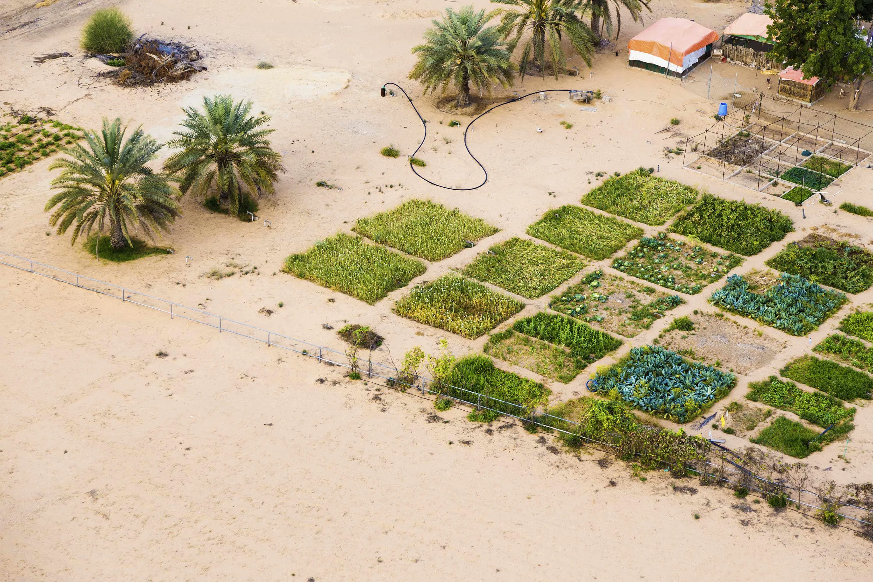
These techniques can help to detect where an oil pipeline may be leaking, as vegetation will recede in these areas. Conversely, we can use the same techniques to spot where a pipeline carrying water may be leaking, as we can detect the vegetation that will spring up in the vicinity of the leak.
Capturing and analysing geospatial data automatically can lead to better policy decisions regarding the provision of food and improve agriculture by reducing operational costs, waste, pesticide use and pollution.
It can also provide insights that allow regions to maximise their yields from harvests by detecting changes in vegetation captured using remote sensing. Better data of this type can have other economic downstream effects, such as reducing insurance premiums for farmers.
Monitor the changing environment
Geospatial data provides us with unique and precise tools to monitor our changing environment, which allows us to accurately take stock of climate change. Monitoring of glaciers, sea levels and polar ice is enhanced with precise and reliable geospatial data. Monitoring and analysing wildfires using geospatial data is a powerful way to manage them - a pressing concern given the devastation wrought by the 2020 wild fires in Australia. Automatic data capture and processing can allow governments to act efficiently and rapidly in the event of natural disasters driven by climate change.
These are just a few ways that cities and nations around the world are harnessing geospatial data and Ordnance Survey’s geospatial skills and experience. Geospatial data is also critical to the emerging smart city technology that local governments are using to optimise their transport networks and improve efficiency and reduce waste in urban areas.
We are working on a number of projects in Dubai to help them effectively implement their smart city strategy. Dubai Municipality already has a sophisticated vision for the future of the city, and are drawing on our expertise to help them realise it.
More than half of the global population currently live in cities, and this is set to expand to almost 70 per cent by 2050, with most of that change taking place in Africa and Asia. Geospatial data is critical for governments in all parts of the world to level-up their economy at a time of rapid population growth and urbanisation. Taking a geospatial readiness assessment can put your city on the right path to tackle the challenges population increase represents for land rights, transport, agriculture and the environment.
By working with Ordnance Survey, you can combine 200 years of mapping expertise with the speed and usability of modern technological innovation, to deliver a solution that harnesses your city’s potential.
See your city smile
Explore how OS can help your city thrive with geospatial data

Director of International