Ordnance Survey’s cartographic house styles
Our cartographers make lots of intricate design decisions to ensure that our maps meet the needs of each of our different users
Our paper maps (and their digital raster data equivalents) carry their own beautiful cartography which is well established and well understood. A great example of this is our OS Explorer Maps. For many, these maps have a sentimental or nostalgic value – they can evoke memories of adventure and can connect the map reader to locations. Cartography is a powerful form of visual communication.
Our cartographic design is diverse – we have mapped Mars and the Moon, and even created beautiful posters of National Parks, motorway junctions and football stadiums. However, for the most part, our mapmakers are focused on designing functional maps for use by members of the public, businesses and government.
For our range of vector data products, our cartographers create stylesheets for use in various mapping software. We share them on Github and they have become an increasingly popular resource amongst our customers.
We have continuously evolved our cartographic house styles. We have recently launched our new suite of mapping APIs on the OS Data Hub where the OS Maps API and OS Vector Tile API have pre-set cartography. Here is some more information about each style which we hope will help you choose the right one for your needs.
Road
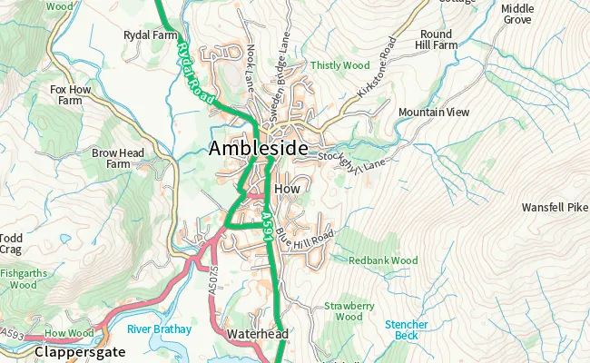
This style carries the classic cartographic tropes that can be seen throughout Ordnance Survey’s history. It looks and feels familiar. There is a clear focus on transportation networks and all the roads carry their classification colours e.g. motorways are blue, primary roads are green, A roads are red and B roads are orange. Use this style if you want a bold, high contrast map.
Outdoor
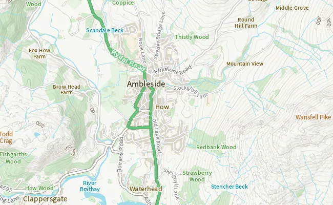
Our Outdoor style has a focus on the natural features in the landscape – there’s lots of green and blue. It offers a modern, de-cluttered aesthetic. From a consumer application for hikers to reporting on environmental issues, Outdoor is a flexible style that can work well for a variety of use cases. This style offers a useful reference map on its own right but is also great as a basemap for data overlays.

Light
This style is designed for use as a backdrop map to add geographic context to your own data. It is almost greyscale, designed with muted tones while retaining a hint of colour to differentiate map features. Blue tints and light touches of green help to distinguish between lakes and forests respectively. There is less contrast across the whole colour palette, so this style has a flatter visual hierarchy. This really helps your own data shine when overlaid. Check out our map style example to see how they look in the new OS Maps API.
Leisure
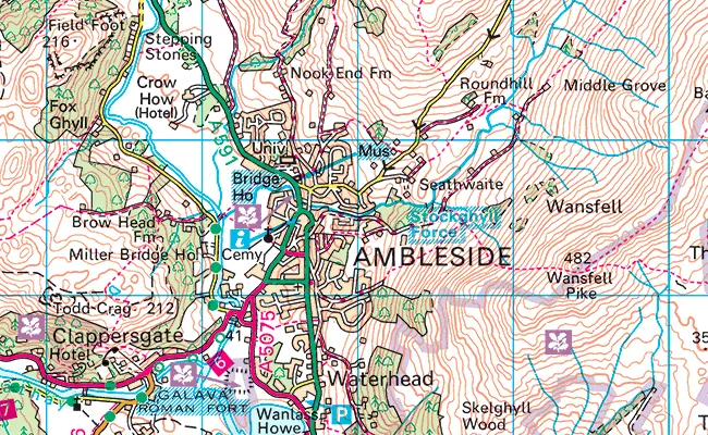
Our Leisure style integrates our raster products into a single map stack, including 1: 25 000 Scale Colour Raster (OS Explorer Maps) and 1: 50 000 Scale Colour Raster (OS Landranger Maps). These maps all have their own, beautiful cartographic styles and combine to create a unique view of the British landscape. Particularly useful for outdoor leisure applications where footpaths and tourist information are important.
Check out our basic map style example to see the Leisure style in the new OS Maps API.
Find your style
You can sign up to the OS Data Hub now and start using our new APIs. Sign up for free – select the OS OpenData plan or choose the Premium plan if you’re creating solutions for others and benefit from up to £1,000 worth of free Premium data each month.
Explore OS Data
Learn about the geospatial data you can get and the plans available
Our data platform provides access to all Ordnance Survey datasets through a suite of APIs and data downloads.
Sharing the latest news about OS. We can license you to use OS maps in print, online and film format. For more information and resources for journalists, bloggers and media professionals, email pressoffice@os.uk or call 023 8005 5565.