Trig pillar trivia
It’s been 225 years since OS was founded and 215 years since we published our first map
We've covered the history of the trig pillar before, so this year we thought we’d celebrate the anniversary by sharing some trig trivia. Have you always wanted to know what the inside of a trig pillar looks like or why some are circular? Keep reading…
The last observation
Whilst trig pillars were of course used more than once, the last trig pillar from which retriangulation observations were made was Thorny Gale in Cumbria on 4th June 1962. It has a similar plaque to the one found at Cold Ashby.
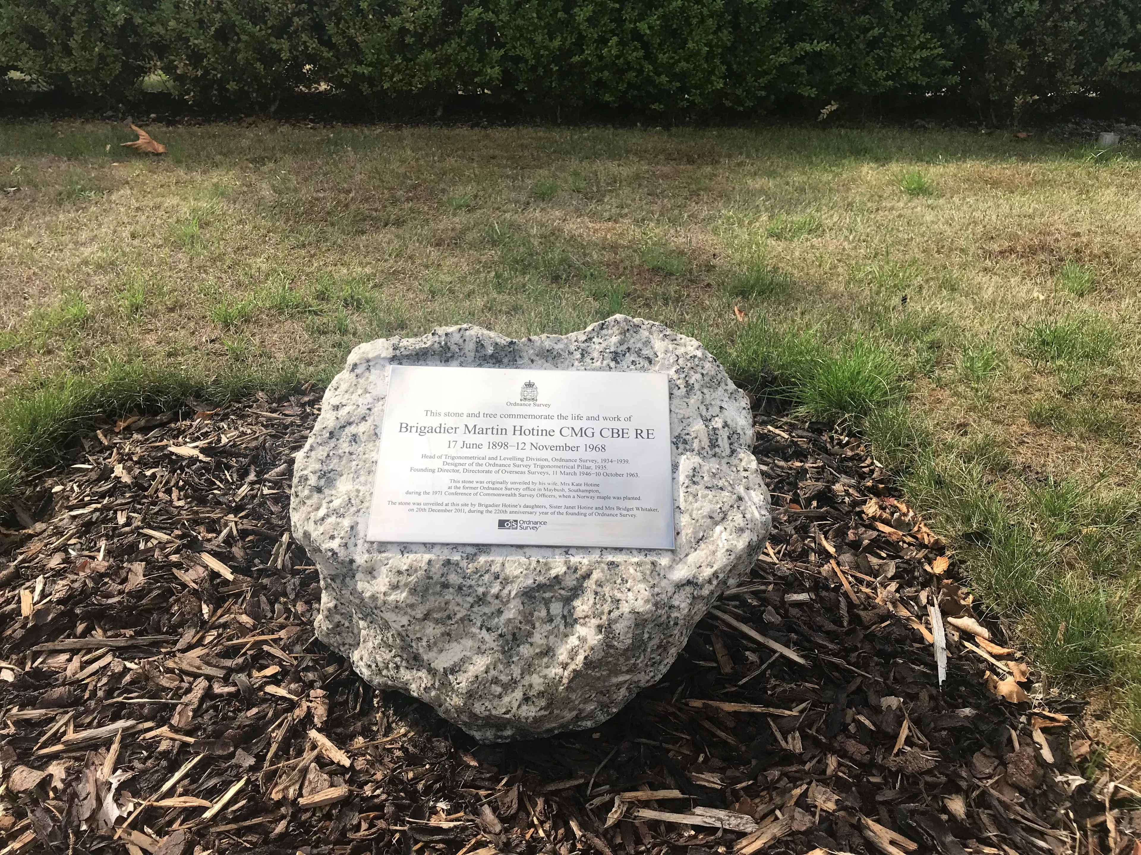
The person behind the trig pillar network
Brigadier Martin Hotine was the person responsible for the design, planning and implementation of the re-triangulation of Great Britain on which OS maps are still based. Find out more about Hotine's life and the Hotine Memorial Stone at OS HQ in this blog.
Ben Nevis is the highest
As you may have guessed, the trig pillar atop Ben Nevis is definitely the one closest to the clouds!
Believe it or not, back in 2016 we discovered Ben Nevis was a little taller than we originally thought. You may be wondering how we were able to survey such a height back in 1949 – find out more.
Little Ouse is the lowest
Whilst trig pillars are often on peaks of hills, the lowest trig pillar sits at -0.533m below sea level and is located near Ely in Cambridgeshire.
Some pillars were never used
There were several trig pillars built but never actually included in the retriangulation. Some were even built for other initiatives including the monitoring of the Great Glen and the Channel Tunnel survey (to establish a control network prior to excavations starting). Additionally, some were built for non-OS projects.
The complex brass fitting
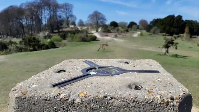
The brass fitting on the top of a pillar (three grooves set at 120deg apart) is known as a ‘Spider’. This is a ‘forced centring’ device to ensure any survey instrument (such as a theodolite) is centred over the reference mark. The brass loops on the top are so that the instrument can be tied down in windy weather. Read more about theodolites here.
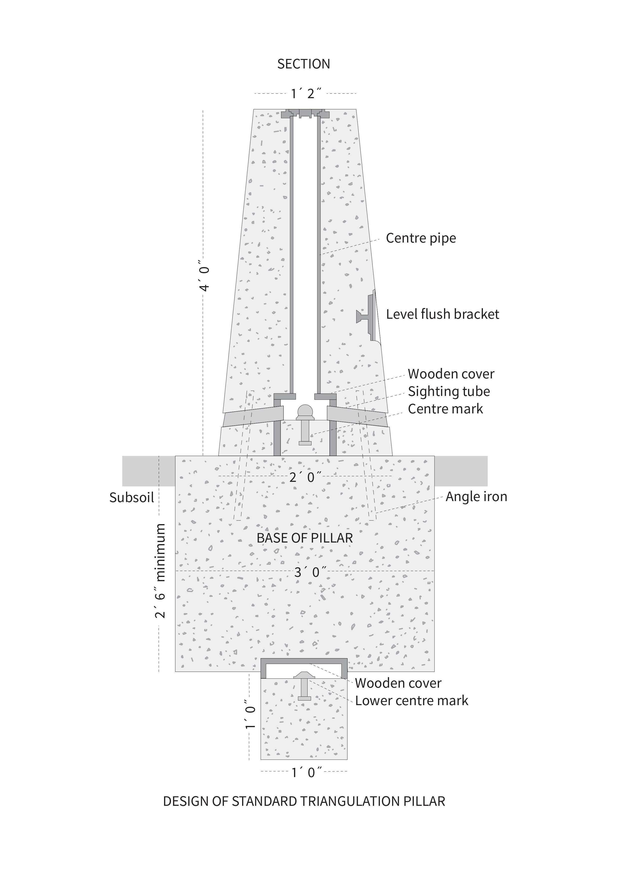
The internal workings
If you follow us on Twitter or Instagram, you may have seen us share an image that illustrates the inside of a trig pillar. Every time without fail, people are fascinated. Like an iceberg, there is more of trig pillar below the surface than above it!
Cylindrical trigs
Mainly found in Scotland, the circular style pillars are known as Vanessas. The reason for the name isn't as exciting as we'd hope though as they were simply named after the company (Vanesta) that produced the cardboard tubes used to cast them (and yes, Vanesta were better known for washroom products!). This design was used as it required less materials to construct and as a result saved on transport costs.
Trig bagging
A popular site to spot when out in the countryside, some make it their mission to visit trig pillars – aka trig bagging. Whilst they are identified on our Explorer maps by a small blue triangle with a dot in the middle, many people download the complete trig archive from our website to track them down. If this sounds like your kind of thing, Trig Pointing UK seems to be a popular site for trig baggers.
Benchmarks are older than trig pillars
Although benchmarks have been around for a very long time, many don't realise they’ve been about much longer than our renowned trig pillars. While trig pillars were used in the National Grid as accurate fixed points for mapping coordinates, benchmarks were fixed points which were used to mark heights above the mean sea level. In addition, most (but not all) trig pillars also have a flush bracket to define their height above sea level.
The height reference point for any trig pillar fitted with a flush bracket is the top of the arrowhead. For a trig pillar, the office file would also contain the height difference of the flush bracket to the natural ground level at the base of the pillar, as well as the difference to the highest point of the hill (if different).
Find out more about benchmarks and how to track them via OS Maps desktop.
How accurate were they?
The survey control network of trig pillars was accurate to 20 metres over the entire length of Great Britain. Today, the receivers that make up the OS Net network are coordinated to an accuracy of just 3 mm over the same area.

They're everywhere!
6,500 trig pillars were built for the retriangulation of which around 5,500 are still standing. In total, the retriangulation had in excess of 30,000 coordinated points. The modern OS Net network performs the same function with just 110 points.
How do OS survey today?
The modern equivalent is the OS Net network of 110 Global Navigation Satellite System (GNSS) receivers. Our surveyors use OS Net and GNSS technology every day to instantly position new map detail to within a few centimetres. What took many hours at Cold Ashby in 1936 we can now do in seconds and to a far greater degree of accuracy.
Interested in the trig pillar map? Explore our interactive version.
Looking to learn more about our surveying past? Discover The History of the Retriangulation of great Britain 1935-1962 (please note this is a large PDF file and can take a while to load).
So there you have it, some top trig pillar trivia we hope you've found interesting. Next time you're out in the British countryside, don't forget to take a photo and tag us on Twitter and/or Instagram!

Our highly accurate geospatial data and printed maps help individuals, governments and companies to understand the world, both in Britain and overseas.