DfT project explores potential for residential electric vehicle charging
Working with the Environment Statistics team within the DfT, I’m involved in helping to plan for the future provision of electric vehicle (EV) charge points across the UK.
In a future where vehicles are fully or partially electric, all vehicle users will require adequate access to charge points. The demand on the electricity grid is an important consideration, and to mitigate this the majority of charging should take place at night outside peak hours of electricity consumption. To achieve this it is likely that many charge points will need to be located very close to the property of the vehicle owner, making it important to understand parking availability.
The challenge is that there is no definitive existing dataset that quantifies residential parking availability for the UK. Although various datasets exist which include some information, more research needs to be done to support the planning process.
Project scope and methodology
As part of the MSc I am undertaking in Data Science I was looking for a complex project that would support my work at DfT. I decided to focus on how I could help quantify the proportion of uncovered off-street parking in a 1 km2 residential test area, with the potential to scale the project at a later stage to cover the whole of the country.
The aims of the project were to examine the front garden area of residential properties to determine if they may be used for parking and to accommodate a private charge point powered via the household electricity supply.
It seemed like the obvious place to start would be to look at maps and aerial photography. I already had access to Ordnance Survey data through the Public Sector Geospatial Agreement (PSGA) and aerial photography from Bluesky International and Getmapping PLC through the Aerial Photography Great Britain (APGB) contract that cover the public sector, so I set about determining how I could link and leverage the data to find what I needed to know.
The topography area layer of OS MasterMap contains vectorized polygons of every shape that together make up a jigsaw of the UK, for example gardens, roads, pavements and buildings. All OS maps use the British National Grid coordinate reference system. Other useful fields include the polygon unique identifier, or topographic identifier (TOID), and various descriptive fields which enable detailed filtering. Ordnance Survey’s AddressBase Plus also contains a unique property reference number (UPRN) for every postal address in the UK, along with point geometry for its location and the building TOID that it matches in the Topography Area layer.
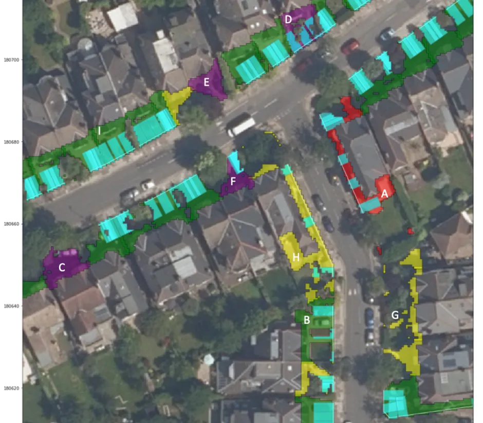
APGB products are raster images of 1 km2 grids that also align with the British National Grid. I used the OS MasterMap Topography Layer and AddressBase Plus to identify the residential properties and the associated vector polygons and then matched the OS data with the aerial imagery from APGB using the national grid coordinates. What was more challenging was associating gardens to residences. I used HM Land Registry INSPIRE polygons which show the full extent of the property to do this, intersecting with representative points of the OS constituent parts, to ensure each residential address was linked to the correct garden.
Finally, I used a remote sensing vegetation index to analyse the photography and segment gardens into vegetation and manmade surface. From there I went on to identify whether the manmade surface area was adjacent to the roadside and the right size and shape to accommodate a vehicle. I was able to develop an algorithm that checked all front garden images and classified residential dwellings in the test area as either ‘parking possible’ or ‘no parking’.
A geospatial dimension
I used Python to write the code for the project. Python and the whole domain of geospatial data were completely new to me at the outset of the project. The team at OS were very helpful, advising on how best to use the data and suggesting libraries I would find useful like Rasterio and Shapely. This saved me a lot of time.
I also have access to GIS tools at DfT – and although I hadn’t used these before, and they weren’t needed for the analysis itself – it was helpful to look at QGIS on the side as a sense check of what I was looking at. I’ve really enjoyed working with geospatial data – being able to see what you’ve done and map it all has been very rewarding. It provides a tangible dimension to a data science project.
Findings and next steps
My findings show that the proportion of residential dwellings with off-street parking within the 1 km2 suburban test area is about 46%. A manual labelling of each image estimated the proportion to be 53%, indicating that the model slightly underestimates the true proportion. However, the algorithm and the manual labelling showed strong agreement (84%), demonstrating the viability of this method for identifying off-street parking on residential sites.
The next step would be to scale this method to identify off-street parking for every residential dwelling in the UK. I’m also interested in possibly incorporating machine learning techniques into the next phase of the project, but I have no clear plans as yet. I welcome further input and ideas from the OS team and others as we work towards a cleaner future.
OS for developers
Whether you’re new to geospatial or a GIS data expert, our data platform grants access to our data

Our highly accurate geospatial data and printed maps help individuals, governments and companies to understand the world, both in Britain and overseas.
Find more blog articles
- Electric vehicles
- Developers