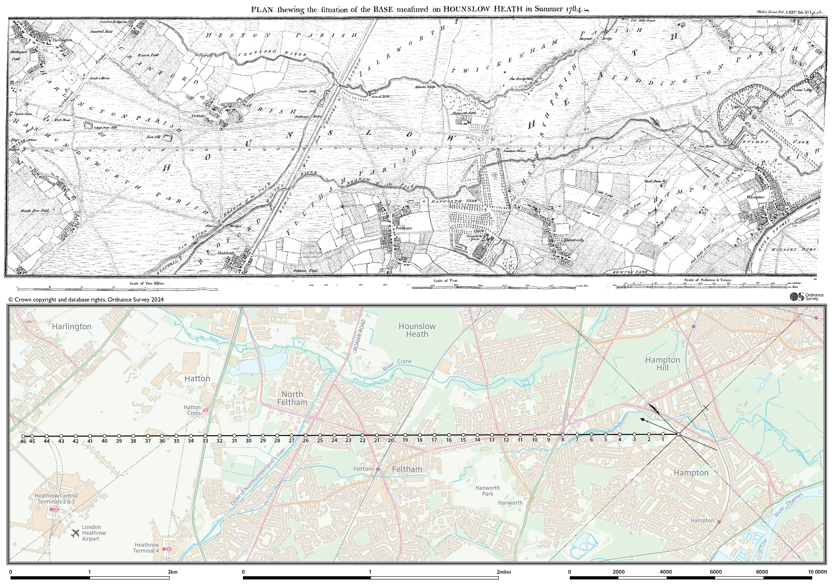
William Roy’s surveying baseline: the 240th anniversary
How Ordnance Survey began
In 1784, innovative engineer William Roy was commissioned to carry out a ‘geodetic survey’ on behalf of King George III and The Royal Society, and under the authority of the Master General of the Board of Ordnance.
His task was to connect the Royal Observatories of Greenwich and Paris, to solve a dispute over their relative positions. To do this he needed a more sophisticated theodolite (a precision instrument for measuring angles horizontally and vertically) than had previously existed.
A geodetic survey takes into consideration the size and shape of the Earth, to precisely locate horizontal and vertical positions. It was necessary to measure a baseline to begin the survey, and during the summer of 1784, Roy established his baseline on the flattest suitable ground: Hounslow Heath. He measured the baseline between Hampton Poor House and King's Arbour, at a distance of 27,404.01 feet (8.352km).
It was a laborious task. The first measurement was reached using wooden rods, each 20 ft in length; however measurements could differ depending on whether the rods were wet or dry. The rods were replaced by one-inch-thick glass tubes of the same length. They were supported on trestles, then the ends were aligned to an accuracy of a thousandth part of an inch. The first rod was then carried to the end of the third, an operation which had to be repeated more than 1,000 times.
Perhaps taking lessons from this, after 1791 baselines were measured instead with steel chains, each 100 ft long.
Using the best available technology
To complete his geodetic survey, and achieve such accuracy, Roy needed a sophisticated theodolite; one more advanced than those available at the time. Jesse Ramsden, the leading instrument maker of the day, produced a spectacular Great Theodolite. It needed to be employed on hills and a moveable tower, and took three years to complete.
Following his success, the Board of Ordnance bought a second new (and improved) Ramsden theodolite. That was 1791. Roy’s geodetic survey had taken six years of dedication and hard work.
With the purchase of the second Ramsden theodolite, 21 June 1791 became officially recognised as the birth of Ordnance Survey.

What happened to the baseline?
The north-western portion of the baseline is now occupied by Heathrow Airport. Thanks to the generosity of Heathrow Airport Ltd., their contractors have remounted a plaque on a masonry plinth within 20 metres of its original position, on the northwestern side of the adjacent Nene Road Roundabout. You can still visit and identify the site of significant importance to the history of British national mapping.
A lot has happened in the intervening centuries. The 1784 geodetic survey was just the beginning. One of the first projects of the newly established Ordnance Survey was to remeasure Roy’s baseline in 1791. Captain (later Major General) William Mudge FRS RA found the baseline was 0.23 feet longer. A further re-measurement by Ordnance Survey geodesist Alexander Ross Clarke in 1858 determined the length to be 27,406.19 feet (8.353 Km).
The immediate lesson is that surveying is an ongoing process. Methods and technologies to survey the land will advance to produce even more accurate results, while landscapes are constantly changing with natural and manmade alterations; updates which need to be recorded.
240 years later…
There are always new measurements to make, and new ways in which to make them.
That’s why OS has surveyors, drones, and aircraft, to capture the changes to Great Britain and provide the most accurate, current data possible. That’s why we follow the rise of new technologies, such as Earth observation satellite data and machine learning, to keep our data authoritative, and efficient. And that’s why we will continue tracking geospatial advancements and surveying Great Britain, much like William Roy using the Ramsden theodolite, 240 years ago.
Roy had been convinced that ‘the honour of the nation’ depended on creating ‘a map of the British islands’ that was ‘greatly superior in point and accuracy to any that is now extant’.
21 June 1791 is officially recognised as the birth of Ordnance Survey. At the time, it had collaborated with experts, like William Roy, and had acquired the best technology and equipment available. Though more than two centuries have passed, our dedication to accurate mapping, and keeping pace with the latest geospatial innovation, have remained with us all along.
Discover the history of Ordnance Survey

Our highly accurate geospatial data and printed maps help individuals, governments and companies to understand the world, both in Britain and overseas.