Challenge
Climate change and extreme weather events present real, escalating risks to communities, businesses, assets, and infrastructure, often with severe health and economic impacts. The UK Climate Change Risk Assessment (CCRA) has concluded that progress with climate adaptation policy, and critically its implementation, is not keeping up with the rate of increased climate risk.
In both the public and private sectors, organisations face challenges in developing effective, informative climate adaptation and resilience plans – on nationwide and localised scales. For example, property lenders and responsible banks forecasting locations at risk of increased flooding; government agencies considering the environmental and health impacts of rising temperatures, and heat mapping.
Decision makers have myriad policy investment options at their disposal, and need to make crucial decisions ahead of a future climate state which is highly uncertain, complex, and dynamic. Much like the technical solutions that are evolving and emerging in response.
It therefore demands an incredibly high degree of scenario evaluation and assessment, which in turn relies on the best possible foundation of available data, to provide confidence to act at the pace that is required.
Organisations need to gather climate hazard and risk data, and combine this with their own data (assets, communities, infrastructure etc) in a temporal and spatial context, undertake future scenario modelling and analyses across multiple risks (flood, heat, wind etc), so they can plan and implement the right mitigation and adaptation strategies.
However, acquiring such critical insight can be severely limited by significant challenges:
- Complex, highly fragmented data required from multiple sources
- High-level analysis, lacking in localised, place-based context that is often siloed, preventing a holistic, system-level assessment
- Limited in-house expertise or support
Overcoming these challenges is not trivial and can result in a lengthy, time-consuming processes. Fragmented or generalised data can also be harder to optimise and visualise, making it harder to draw insight and engage stakeholders to drive the changes needed, at the pace they are needed.
Solution
SimAnalytica has developed a suite of digital applications, built on a core platform called Compass: Engine™. A cloud-based software capability, with a unique ability to connect disparate datasets, and integrate siloed analytics. Data transforms into a body of knowledge and insight, by unlocking team capacity to explore a wide range of scenarios, at speed. At the foundation of this is the place-based information from Ordnance Survey.
As an example, a local authority or organisation interested in assessing climate risks around a specific area of properties would need to combine a variety of datasets such as census data, Energy Performance Certificates (EPCs), carbon emissions, heat mapping, and more, to build an accurate, granular representation.
Compass: Engine™ can unite datasets, and does so focused around three key dimensions: assets, place, and time – essentially, the What, Where, and When. The ‘asset’ can depend on the user, the organisation involved: a property, an electricity substation, a road, a trainline, and so on.
For the ‘Where,’ SimAnalytica leverages a range of OS mapping and datasets. OS MasterMap Topography Layers serve as the basemap, and additional products OS MasterMap Highway Networks, OS Open UPRN (for addressing), and OS MasterMap Building Height Attribute ensure the assets, the ‘What,’ are accurately located and recorded.
This links with context-based ‘time’ data – the ‘When’ ranging across scales from short-span granular durations such as AM and PM peak traffic flows, to days, months, seasons and decades depending on the question to be answered. Compass: Engine™ can be used as a platform to then build intricate and insightful scenario models within its suite of supporting applications – unlocking the capacity for teams to examine a vast array of “what if?” scenarios.
As General Purpose Technology, Compass: Engine™ enables repeatable applications and applies context to a range of enquiries; the focus isn’t climate risk assessments, alone. SimAnalytica has developed four applications so far: Climate, Energy, Transport, and Carbon, with more in development. These applications can be connected, too: ‘Transport’ can be used for traffic planning, while ‘Climate’ becomes relevant during a flood scenario, as traffic routes would need to be altered during floods to try and alleviate congestion.
Compass: Engine™ applies a flexible, scalable approach to data, models and simulation, digital twins, and AI. With Compass: Engine™, just as multiple datasets and analytics can be integrated to build one scenario, the power of the software unlocks team capacity to explore more scenario combinations.

Result
Through automated linking and contextualisation of relevant data, and embedding future climate scenario models, SimAnalytica has developed an intuitive climate risk assessment solution. One that is easy to use, scalable, and enables better informed planning, monitoring, and responding to climate-related circumstances.
"Working to ‘business as usual’ isn’t going to cut it anymore. At the click of a button, Compass: Engine™ connects datasets to configure and run the analytic assessments. Our users have the power to explore myriads of scenarios, not spending their time wrangling data or trying to break down data and analytic silos. They have the same resources at their disposal, but can do more with what they have, and unlock deeper critical insight faster, at lower cost."
Benefits
In real world projects such as those outlined below, the Compass: Climate application has been shown to deliver:
- a x3 reduction in the time required to complete a climate risk assessment
- significant savings on both the design of future assets and infrastructure
- tens of millions of pounds in lifecycle maintenance cost reduction resulting from climate impact
Customer examples: SimAnalytica's data modelling
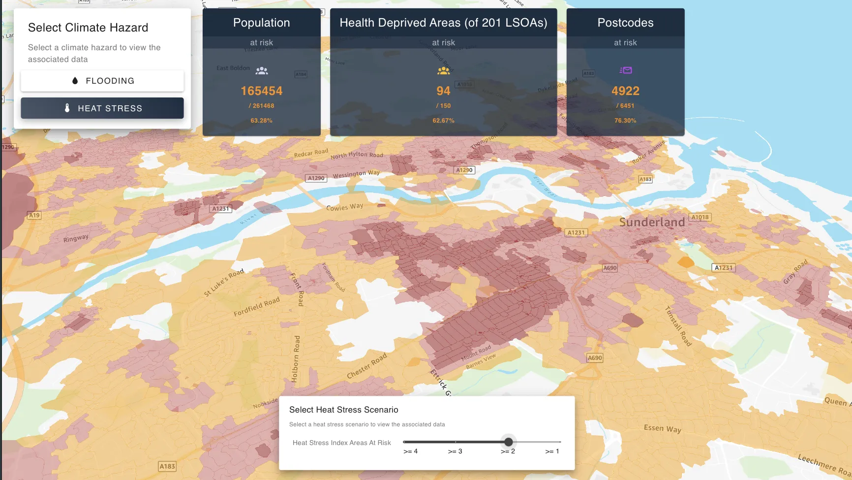
Sunderland City Council
In early 2024, Sunderland City Council (SCC) delivered its own data modelling proof of concept, by working in partnership with SimAnalytica.
SCC has committed itself to becoming a vibrant smart city and reducing carbon emissions, aiming to make the city carbon neutral by 2040. SCC collaborated with SimAnalytica (known at the time as Slingshot Simulations) to develop a proof of concept, for scenario modelling and decision making, using its Compass: Engine™ platform.
As a starting example, SCC wanted to better understand changes in traffic and emissions by implementing various measures such as narrowing carriageways or making them pedestrianised. SimAnalytica’s simulation investigated the impact of various interventions at different peak timeframes, with data from SCC’s own sensors to simulate traffic. The interventions could then be compared against a baseline ‘do nothing’ scenario.
The digital twin proof of concept enabled SCC to identify emerging challenges and areas that demanded immediate attention. Through simulating various scenarios and interventions, the Council assessed the expected impact on both traffic patterns and carbon emissions, thereby facilitating quick and targeted decision making.
The insights generated by the simulation are actionable and will pave the way for more in-depth analysis and design, ultimately leading to tangible changes in the physical world.
Sunderland City Council reported:
"We now have a clearer understanding of how interventions will affect the city: thereby facilitating quick and targeted decision making. Our ability to conduct transport and environmental simulations with a focus on emissions and traffic impacts brings us a step closer to our vision of a smart and sustainable Sunderland."
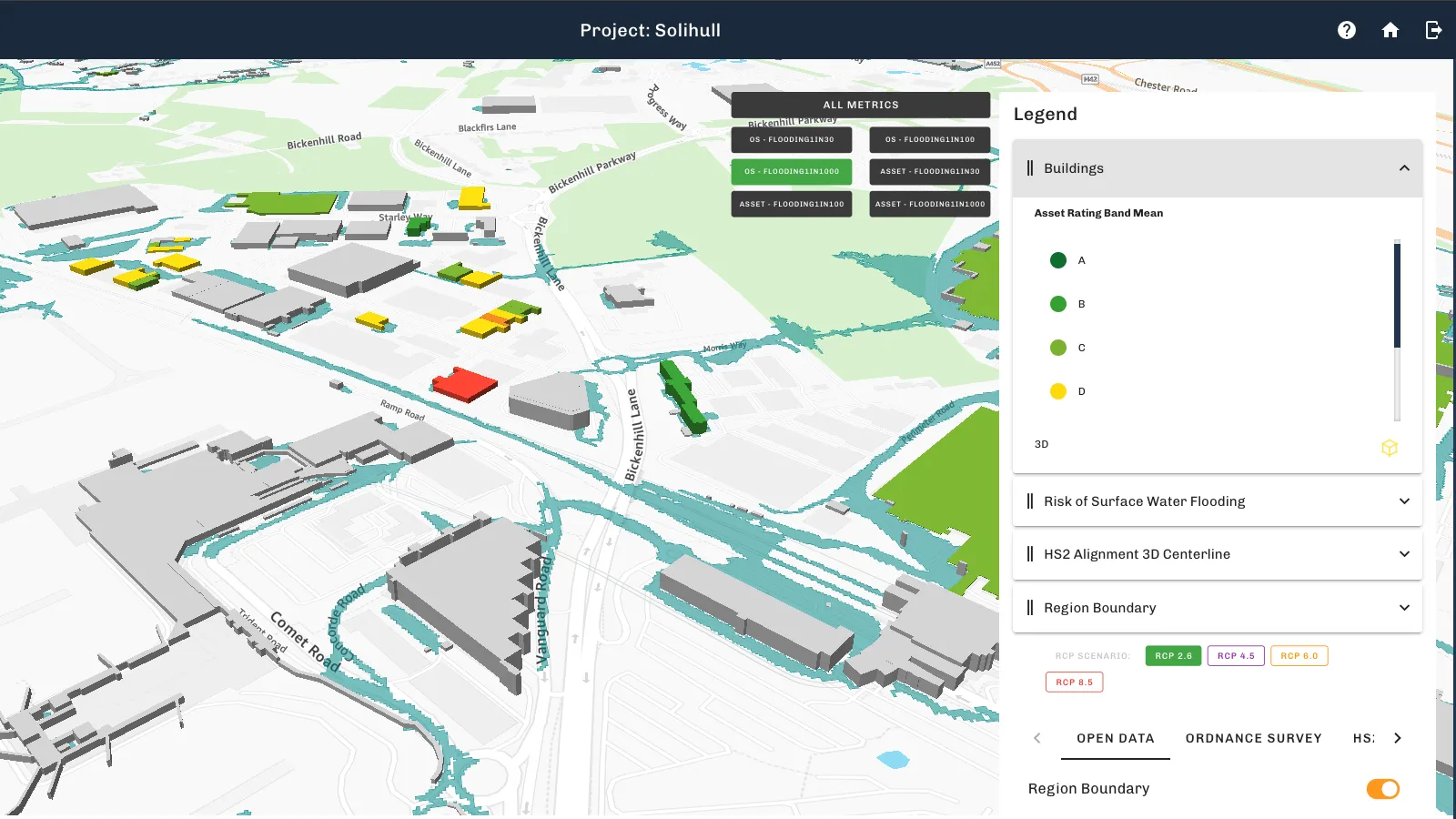
HS2
HS2 is Britain’s new high-speed railway, connecting London and Birmingham. Following participation in HS2’s Innovation Accelerator Programme, SimAnalytica is working with HS2’s Climate Team to apply their technology to help advance the climate vulnerability assessment process, and enable the more rapid and cost-effective identification and management of future climate effects on HS2 assets.
In the initial phase of work, the vulnerability assessment considered asset exposure to hazards in multiple future climate risk scenarios across two locations and a total combined track length of 33.2km. Assets forming part of the analysis included track, tunnels, cuttings, embankments, retaining walls, stations, and viaducts. Hazards include surface water flooding, groundwater flooding, river flooding, subsidence, high winds, overheating, wildfires, and high humidity.
SimAnalytica’s Compass: Climate application, combined with climate domain expertise, provided automated cloud-based data pipelines, geospatial analysis, and climate risk scoring. The risk scoring is a weighted composite score per asset for each km of track, considering both likelihood and impact across types of climate hazard. This work combined public and private data to provide scores, with data sources from HS2, DEFRA, UKCRP, and the Met Office - founded on high-quality, high-fidelity OS geospatial data.
The application provides a range of options for dissecting climate hazard data and visualising predicted implications for critical assets in context of a wide range of uncertain risk scenarios and the projects future operations. This is critical for investment decision making with confidence, and for engaging key stakeholders early in the process.
Compared with business-as-usual approaches, Compass: Climate was shown to accelerate data capture analysis by a factor of three, freeing up weeks of team capacity, and the improved insights estimated to have saved over £20MN in climate related asset maintenance efficiencies.
Join the OS Partner network
SimAnalytica has joined other OS Licensed Partners that benefit from OS data, and use it to develop their own innovative solutions. Discover how SimAnalytica’s risk assessment and scenario modelling can improve your decision making by exploring our OS Net Partners.
Or if you’d be interested in registering as a Channel Partner, get in touch with us today by clicking below.
(All imagery generated for this case study are for illustrative purposes only and do not show actual data used in the projects.)
"By partnering with Ordnance Survey and its best-in-class location data, we have more capability than we’ve ever had before, which we’re able to pass on to our users. The quality of the underlying data gives them not only a chance to make better decisions, faster, and for a lower cost, but also the confidence they need when making those decisions."