Challenge
Local Place Plans
National Planning Framework 4 (NPF4), Scotland’s new planning framework, includes a statutory right for community bodies to prepare a Local Place Plan (LPP) to set out their proposals for the development and use of land. Scotland and Wales use LPPs, though they’re known as Neighbourhood Plans in England.
Local Place Plans are community-led plans setting out proposals for the development and use of land. Introduced by the 2019 Act, these plans will set out a community’s aspirations for its future development. Once completed and registered with the local authority, LPPs must be regarded in the development of the new Local Development Plan, and become a material consideration for future planning decisions for the area.
This is an exciting opportunity for communities to be involved in the long-term future of their place and the community in Thornhill decided to take up this invitation.
If a community chooses to prepare an LPP, it must fulfil certain criteria:
- Local Place Plans must, if they are to be registered by your local authority, comply with legal requirements.
- Local Place Plans should express a clear vision for the future, including a spatial map, indicating where changes should occur, along with an action plan detailing how these changes will be implemented.
(Sources: Supporting documents - Local place plans: literature review and final report - gov.scot and Local Place Plans – ‘How To’ Guide: Literature Review and Final Report)
Mapping with limited geospatial skills
Thornhill has a Community Action Plan, with reporting, priorities, and actions – such as developing more walking and cycling routes, improved traffic management solutions, reviewing local speed limits, and so on. Important criteria, reviewed for the betterment of the local citizens.
Preparing the LPP gave the community a statutory right to have proposals for developments and use of land considered by the planning system – for the first time. It was that incentive that encouraged the Council towards needing accurate and clear maps to support its proposals.
However, when it came to preparing the LPP, the Council faced two immediate challenges: a lack of funding, and limited Geographic Information System (GIS) skills among its members, to create accurate spatial mapping. Being a voluntary organisation, with limited funds and time for training and resources, made these significant obstacles to creating an LPP that met requirements.
Solution
Thornhill & Blairdrummond Community Council was eligible to sign up to the Public Sector Geospatial Agreement (PSGA) through Ordnance Survey (OS). When registered with the PSGA, public sector organisations can make full use of OS data and services.
In addition to OS location data and expertise, the Council could benefit from the ‘Community Map Scotland’ initiative. Community Map Scotland supports mapping projects, and gives community councils like Thornhill & Blairdrummond more input on planning policies and developments in the local area.
The initiative gives local communities free access to digital mapping software to support their LPPs, and other community projects. Those involved can access Parish Online software, via the Community Map Scotland initiative, for free for a whole year. This has been funded by Parish Online directly through its not-for-profit remit, to promote the use of digital mapping and improve digital competency in local government.
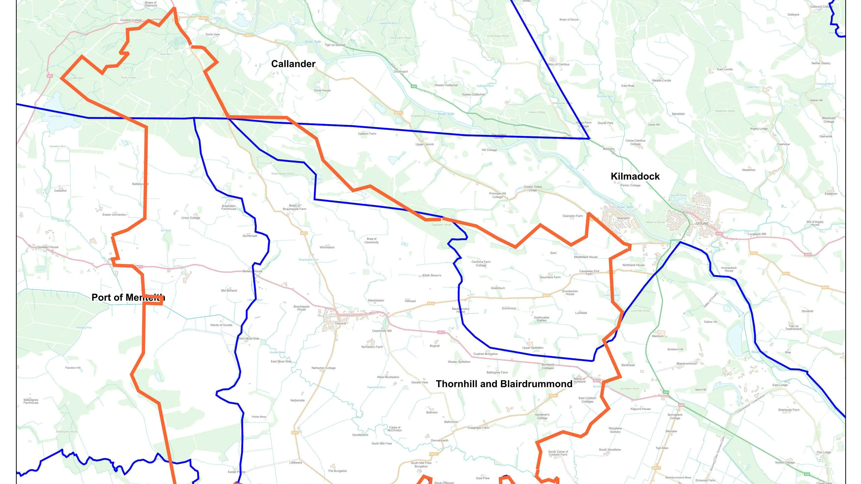
An example of Parish Online mapping, a boundary map based on postcode units, is shown below:
Result
Parish Online is software provided by Geoxphere Ltd, a Partner with OS, designed to support local authorities as user-friendly and accessible, even for those without technical expertise.
The Council has been able to create accurate, insightful maps, despite limited geospatial skills, and adhere to LPP legal requirements.
Benefits
In Thornhill & Blairdrummond Community Council's 2024 – 2034 LPP, the Council were able to include maps showing valuable information on land types, boundaries, and building types. The Council also produced a pedestrian hazard map, highlighting areas in the village with narrow or no pavements and traffic crossings, which needed to be addressed.
Partners and PSGA
Parish Online is a solution provided by Geoxphere, an OS Partner that specialises in supporting town, parish and community councils with cost-effective mapping software for asset management, neighbourhood plans and other mapping needs. It also provides GOV.UK websites and email. Explore our 'Find an OS Partner' page.
Community councils like Thornhill and Blairdrummond Community Council can take up this statutory right to have their proposals considered. They can also start making full use of OS data and services, and Parish Online software, if they are registered with the PSGA. Discover how to register below.