Appreciation for the UPRN
A personal reflection on the UPRN; the positive impacts it has made, across the spectrum of industries, sectors, and organisations
Adoption of the UPRN
It’s now over a year later, and my understanding and appreciation for the UPRN has developed. And rather suitably, the geospatial sector has been learning alongside me. Movements in the sector suggests that understanding and appreciation for the UPRN itself is growing, throughout organisations – and through that, efficacy of the concept.
Because through my research, and meetings with market experts, and speaking with other organisations who had adopted the UPRN, I have come to appreciate how UPRNs become even more effective, by more organisations understanding and adopting them.
And more organisations, across the public and private sectors, are adopting the UPRN; to help them remain more competitive, and improve their efficiencies and regulation.
What is a UPRN?
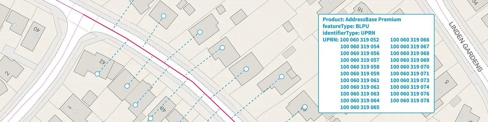
I’ve encountered various methods used to define or better understand the UPRN: a numeric identifier, up to 12 digits in length. Similar to a National Insurance number, or a car registration plate. You may recognise these for yourself.
The best one I’ve heard is the UPRN described as ‘one level below the postcode.’
Postcodes are certainly valuable, and served us well for decades, but there remains room for an even more granular level of geography. For example, there are 124 postcode areas, and roughly 1.7 million postcodes in the United Kingdom.
The total number of live UPRN records is 38,474,050.
The average size of a postcode area is 776 square miles, and the average population is 533,000, while each individual postcode covers an average of about 15 properties. Some postcodes can hold up to 100. UPRNs serve as a unique identifier for a single addressable location – a building, a house, an individual flat in a block, and so on.
The unique identifier, that extra layer of detail, helps reduce ambiguity. It applies a ‘common standard’ for addressable buildings and objects. One that is machine-readable, and in a consistent reference format.
UPRNs and the NHS
During 2021, a year which certainly put extreme pressure on the healthcare sector, the NHS London Healthy Urban Development Unit (NHS HUDU) wanted to match existing addresses to the UPRN, using addressing data. The records they had been using – locations of health infrastructure, GPs, hospitals – weren’t adequate for accurately assessing their assets and model accessibility.
They needed that more granular level of geography. Through doing so, they could continue aligning housing development planning and health programmes in London – to narrow health inequalities, and make sure everyone has access to the healthcare they need.
Ordnance Survey advised on the flow of AddressBase data, including the use of the UPRN, through the Test & Trace process, so that address information could be used for analysis.
NHS HUDU is also using OS Maps API to help produce detailed static mapping evidence, to support health location planning, in conjunction with UPRN matching.
Covid-19 tracing
Using the UPRN as an address-based identifier made it a valuable asset in tracking, and then managing, the outbreak and spread of Covid-19 during the pandemic.
A recent study, published in Emerging Infectious Diseases, focused on increases in Covid-19 cases and outbreaks among students returning to their universities in September 2020.
Students residing in student accommodations could be identified by matching their residential addresses with national property databases. Then, the types of accommodation (such as student accommodation) could be identified, by matching the case patient address with its appropriate UPRN (using the Ordnance Survey AddressBase Premium database). This data mapping enabled precise locating of any case patients to a particular area of residence, and data could then be compared.
Having this information in place helped gain significant insight, such as the average age of case patients, whether more males or females were afflicted, and the locations of highest outbreaks. With these findings in mind, implementing appropriate Covid-19 restrictions meant that students could reduce risk of infection, and focus on their studies and university experience.
Defibrillators
Ordnance Survey (OS) has supported the British Heart Foundation (BHF) in developing a new national defibrillator database. Known as The Circuit, the new mapping tool geo references defibrillators across the UK, connecting them directly and automatically to each ambulance service.
Some defibrillators never get used because emergency services don’t know where they are or how to access them. But given that a defibrillator’s location can be the difference between life and death, knowing its precise location is vital.
UPRNs are being used to help people register defibrillator locations – and register them quickly. Traditional addressing methods proved inconducive to finding them in emergency situations, but the unique identifier helps reduce ambiguity in a location being considered.
The UPRN and unification of data
Beneficial to the healthcare sector, undeniably – these organisations are able to update their records, and use an extra datapoint to literally help save lives.
But there is still more to UPRNs than record cleansing and data accuracy. The machine-readable, ‘common standard’ that comes with the digits can improve communication between separate organisations, and so, achieve unification of data. Organisations perform and maintain data entry by different methods, in different formats, and on different platforms. It becomes harder and more time consuming to communicate the same address between them; and harder still, should a query relate to an object that has no literal address.
UPRNs and local authorities
That’s the concept of the UPRN, in theory – so, does it work in practice?
Numerous local authorities and councils across Great Britain have already adopted the UPRN into their processes and have benefitted from unified departments and consolidated intelligence. Local authorities have been perceived as siloed, with multiple teams and datasets separate from one another. The UPRN, however, can be used to centralise these datasets, and through that, derive new intelligence, insight, and opportunities:
Councils Hull City, and Conwy, North Wales, have seen optimisation in their decision making and interdepartmental communications. Milton Keynes council has combined UPRNs with drone surveying, to speed up property completions. Walsall Council have gone one further, and decided to include the UPRN right from the procurement stage.
(Additional information can be found on the GeoPlace website)
A common identifier – one additional layer of detail in addressing – has helped streamline data sharing and accelerate new solutions. And that isn’t limited to governing bodies, alone.
UPRNs in the property sector
It may not come as a gigantic surprise that the UPRN has had significant impact in the property sector (Milton Keynes Council combining UPRNs with drone data is one example of a great many).
If anything, there was already a deep, underlying need for that additional datapoint; a means of improving communications between organisations. Especially when considering all the processes, paperwork, people, landowners/agents/valuers, local properties, surveyors, consultants, architects, developers – that just one property can accumulate.
(And you can go ahead and multiply that all by however many times, when it’s a block of flats.)
Without the UPRN (or a similar concept) in place, the property sector will remain made up of so many moving pieces; enormous, and fragmented.
An ever-increasing demand
In 2020, the UK government mandated the use of UPRNs in all public sector systems and processes. This decision was influenced by the possibilities of information on properties and locations being managed, maintained, linked, and shared with confidence – and that mandate has helped.
Because, whether encouraged by this mandate or simply driving their own solutions, organisations in the property sector are adopting the UPRN, or pushing for it to be embedded in existing processes.
May 2022 saw the Lettings Industry Council (TLIC) publish a report of recommendations; including the use of UPRNs within the Renter’s Reform Bill. By implementing the UPRN, discrete data points, located throughout public and private databases, can be joined together. Separate records can be unified, to create a single, comprehensive safety record of a property.
There is a clear need in the market for data within the property sector to become unified. These are some examples of how organisations have already benefitted:

UPRN & EPCs
Towards the end of 2021, the Department of Levelling Up, Housing & Communities (DLUHC) incorporated the UPRN into its energy performance certificates (EPCs).
This decision strengthened the property sector. It can provide accurate and relevant data when checking the energy performance data of a property, to ensure safer communities across the nation. It also benefits users, across the supply chain; landlords, residents, local authorities.
A local authority can use UPRNs to check a property’s EPC status. Implementing a central register enables automatic checks on whether a property has a certificate, without having to contact tenants, landlords, or homeowners. The UPRN can identify properties without EPCs to raise the issue, and even build an aggregate picture of the energy performance of other local properties to help decide the most effective way to upgrade them.
By unifying this data, and reducing the time necessary to source relevant information, the UPRN can help save effort and money for the property sector. And the wider UPRNs are adopted across the property sector, the greater the overall benefits will be.
BAPSI
The Home Buyers and Sellers Group have developed the Buyers and Sellers Property Information (BAPSI) pack. The BAPSI will be used as a ‘single source of truth,’ containing all the information required about a property when it is put on the market for sale. Similar in design to Home Information Packs introduced in 2004 – now back, by popular demand.
To achieve their objective, the Home Buyers and Sellers Group the BASPI requires the UPRN for the property, helping to unlock specific information, such as the property’s leasehold details, spray foam insulation, smart home systems, whether it’s a shared ownership, and so on.
This is a step closer to digitising the home buying process, enabling smoother communication and information exchange between the purchaser, and those involved in the supply chain.
It is also a demonstration of a positive change in behaviours. The UPRN is not just being adopted but embedded into processes, helping to remove barriers and delays in longstanding procedures.
National Landlord Register
BAPSI and UPRNs are benefiting the home buying process – what about home renting? There are over four million households in the rented sector, yet Rightmove has recorded that demand exceeds supply, “with prospective tenants outnumbering available rental properties by more than three to one.”
With this heightened need for housing, and prospective tenants in a state of desperation, it’s imperative that they have as much information as possible about the standards of the properties they are viewing and can make more informed decisions about where they will live. And to ensure no-one takes advantage of this situation, local authorities need to be able to target enforcement against rogue landlords.
Suitably, there are proposals for a National Landlord Register in England – helping tenants, local authorities, and even landlords themselves, helping improve their awareness of obligations and property management.
Including the UPRNs in this register can help reduce the risk of errors, duplication, fraud, and increase efficiencies when streamlining any service or sharing data among stakeholders. UPRNs will be a crucial part of managing the myriad datasets that will be contributing to this vast pool of information.
Proptech start-ups - Urban Intel
A government mandate is a significant step forward for the UPRN, and a positive decision. But what of organisations who weren’t mandated; who chose to adopt the UPRNs for themselves?
Proptech start-up Urban Intel has combined EPC data (which now includes the UPRN) with internal square footage, and price paid data, to create a ‘price per square foot’ algorithm. This new pricing tool can help to gain insight into how the market prices may fluctuate, in a given location.
The triangulation of 3 data sets, and creating the ‘price per square foot metric,’ could become a consistent measure for property around the country. It is transferable across local boundaries – cracking national datasets to provide a great view on a national scale, while enabling better understanding of what development is possible, and the gross development value.
While the UPRN is only a piece of their overall data collection and adaptation, it has still played an important role. What could have required a week of development to help clean and match datasets can be completed in a matter of hours. UPRN reduced their turnaround time, and for a start-up, that can be an immensely valuable asset.
Proptech start-ups - SearchLand
Keeping the theme of land and property (there was a crying need, after all) sometimes the UPRN can be used for more than bringing datasets together; it has also helped collate data, and keep specific datasets separate.
The National Polygon Service dataset shows “the indicative shape and position of each boundary of a registered title for land and property in England and Wales. Every freehold or leasehold title has at least one index polygon.” This government-owned service is divides England and Wales into its registered landowners, but therein lies the possibility of multiple buildings being linked to a single plot of owned land.
Geovation-supported start-up SearchLand used the UPRN to identify where there are many buildings to one landowner. This then allows them to link data to the appropriate building and keep datasets separate, and enables their users to make informed property and land decisions.
SearchLand identified that physical addresses can make linking data difficult, while UPRNs provided a robust catalogue of unique records that could be linked to other datasets.
Zoopla
And in more recent news, Zoopla data and analytics chief Antje Bustamante has announced a heavy investment into UPRNs, to improve property data for agents, home movers and lenders. This will help reduce fall-throughs, speed up conveyancing, raise property listing data quality, and improve the quality of leads it provides to agents.
Bustmante noted that their UPRN adoption will “greatly improve the information or ‘data set’ we hold on properties” and help to accurately link properties with their owners.
The UPRN possibilities
The UPRN is helping to transform the property sector – all examples above now share a common thread. (Two common threads, if you count the UPRN itself.) All of them are unifying datasets, and revolutionising existing infrastructure, to streamline and improve their services.
And these outlined examples may just be the beginning. The day may come when solicitors use the UPRN to gather info on a new property; it could improve their administration, possibly even speed up property purchasing timeframes. Given that UPRNs and EPCs now go hand-in-hand, they could mark the end for rogue landlords, as correct housing certificates and safety documents become unmissable links in the chain.
But the UPRN need not be limited to just property. It could see widespread adoption in the logistics sector and see a revolution in home deliveries. A sat-nav’s ‘Search by postcode’ function could become ‘Search by UPRN.’
The potential of the UPRN may not limited from a technical perspective; but one of imagination. Which is why start-ups like Urban Intel implementing it into new solutions is so important. Every sector needs new ideas; and the UPRN – this common standard, this link between data threads – can be a valuable asset.
The UPRN and you
Rather like a vaccination, the UPRN becomes more effective, the more it is used. Organisations who adopt and use it gain a method of cleansing data, and more reliably connecting datasets – which in turn helps to improve communication between separate organisations.
The opportunity to do so has required the application of an identifier – that layer beneath the postcode. With the UPRN’s implementation secured by government mandates, and adoption ongoing across public and private sector, we are starting to see the benefits, and the authority of it.
Your organisation – from long-standing conglomerates, to a budding start-up – can become additional strength in that authority.
Learn more about our AddressBase and Open UPRN products, and see how the UPRN can benefit you, too.

Copywriter, Ordnance Survey
Products and solutions featured in this insight
OS Open UPRN
An open dataset enabling linking, sharing and visualisation of data related to UPRNs.