How Ordnance Survey supports the Met Office in forecasting space weather - and just how disruptive that space weather can be
The Met Office provides critical weather services and world-leading climate science. A lesser known capability is its forecasting of space weather through the dedicated Space Weather Operations Centre. Ordnance Survey (OS), renowned for its expertise in mapping and geospatial data, has been supporting that forecasting through its network of Global Navigation Satellite Systems (GNSS) base stations, known as OS Net.
How space weather occurs and the solar maximum
The Sun has a natural cycle, transitioning between low and high magnetic activity. Approximately every 11 years, the solar cycle reaches its height - this is known as the solar maximum. The Sun’s magnetic poles then flip, marking a transition from an active, stormy phase to a calmer one, reflected in the frequency of sunspots on its surface.
When the Sun’s energy, in the form of ultraviolet light and X-ray radiation, reaches our atmosphere, it causes electrons from the atoms within the atmosphere to be stripped in a process known as ionisation, resulting in an abundance of charged particles. The amount of ionisation is dependent on solar activity, following the 11-year solar cycle.
Each solar cycle is different, with elements such as the peak number of sunspots and length of time at solar maximum before the decline back to solar minimum, varying from cycle to cycle. The last solar maximum was declared in 2014. The USA’s National Oceanic and Atmospheric Administration has confirmed we are currently in a solar maximum period, which can last up to a year.
The impact of solar activity on Earth
Increased solar activity can have wide-ranging impacts on Earth. Space weather can damage electrical power grids, disable satellites and disrupt radio communications. Today’s world is critically reliant upon GNSS - it is a crucial but often overlooked service embedded within many of our digital systems.
Positioning, Navigation and Timing (PNT) services - which are used to facilitate many core functions across our society – can be affected by space weather, from operating our phones, satnavs and online maps, to the navigation systems relied upon by airplanes, ships and trains. Disruption could also include impacts to some ground-based infrastructure, including power grids and utilities. Therefore Critical National infrastructure (CNI) providers - which are dependent upon GNSS for timing services - need to understand the impact and mitigate the effect that space weather has upon GNSS based systems. The cost to the UK economy of just a few days of disruption could be billions of pounds – one reason why space weather is recognised on the National Risk Register.
For more than 20 years, OS Net has defined Great Britain's coordinate reference system (including its position on Earth) and provides GNSS corrections, enabling access to 1cm real time positioning for OS surveyors and partners. Data from those base stations is constantly monitored and analysed for disruption, such as from solar storms. This information is invaluable and is used to help validate and drive Met Office space weather forecasts, along with data from other partners such as British Geological Survey - with these forecasts helping organisations mitigate potential disruption.
"Space weather forecasting is reliant on observations to help inform future forecasts. With sparse data availability when compared to meteorology, every bit of information that can be gathered is useful in not only informing the current space weather forecast, but also for developing our understanding of what to expect in severe space weather events. Data from Ordnance Survey, and that from other partners, is a vital part of the forecasting chain and helps inform the long-term resilience of the UK to severe space weather events."
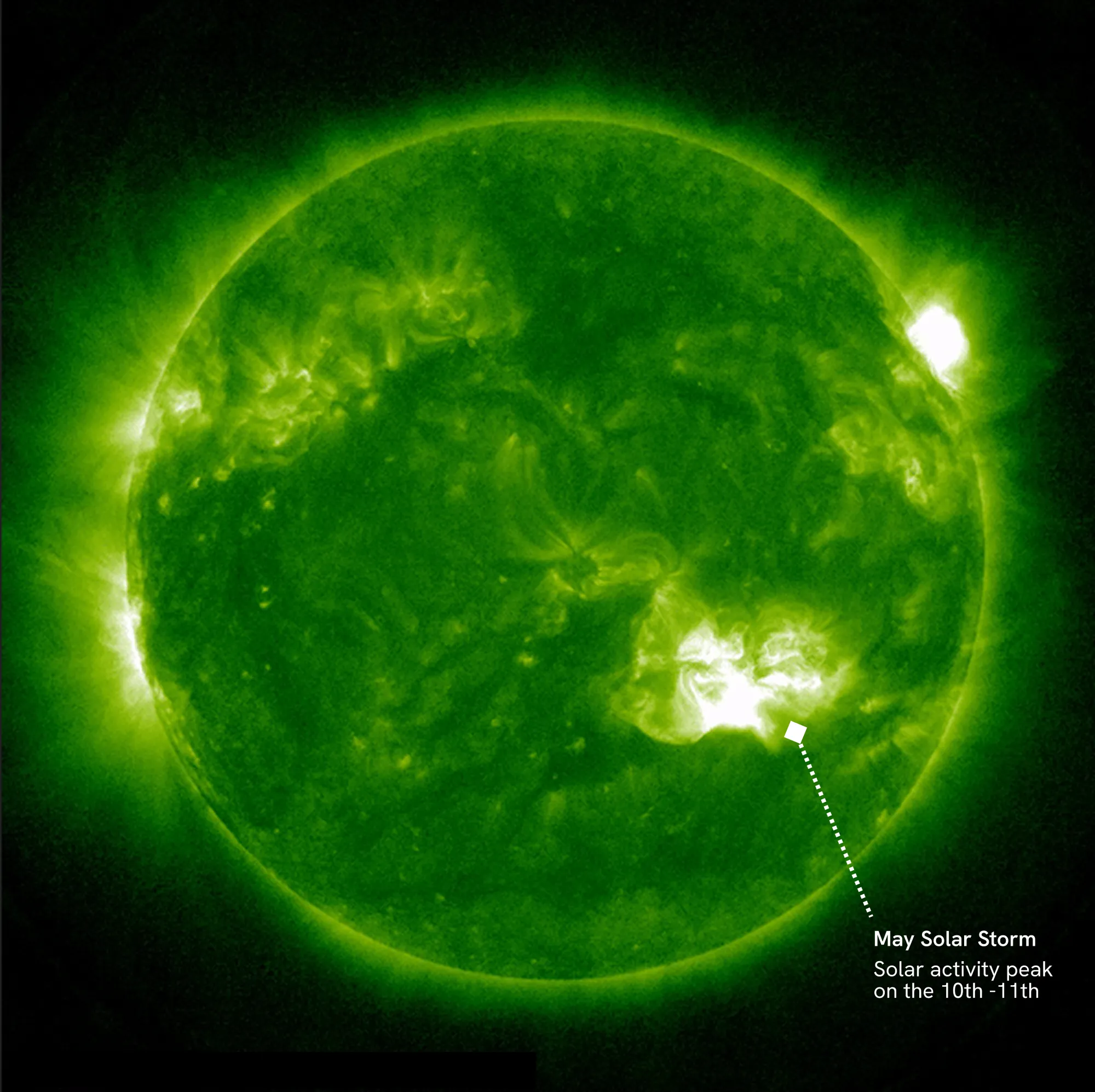
The strongest geomagnetic storm in two decades
May last year saw a notable period of space weather, with a series of solar flares and coronal mass ejections occurring in quick succession. When these arrived at Earth, the resultant geomagnetic storm was declared by the Met Office as the strongest of its type in two decades.
This caused temporary disruption to satellite communications, GPS signals and radio communications, but stopped short of affecting the National Grid. OS Net base stations were affected – they were unable to provide centimetre-level positioning for one hour. Lower levels of disruption were also observed throughout the remainder of the weekend.
These impacts have been fed back to national and international forums to help deepen understanding of what impacts more severe space weather events could bring.
The importance of resilient PNT
Mitigating the effects of space weather on GNSS capabilities is a global and government priority, and one that OS is keen to support through its OS Net capability. An expert in mapping, OS is skilled at deriving insights from complex data, and is highly experienced in building and utilising PNT technologies within machine-to-machine GNSS based networks.
Steve Hancock, Lead Scientist (PNT) at OS, said:
“Ordnance Survey has been defining position within Great Britain for over 230 years, and is now providing highly accurate measurements using our nationwide network of high performance GNSS receivers. As technology evolves, so do the demands placed upon all of us and for OS this means that we continue to explore the development of PNT technologies, systems and services. Today, the demand for resilient PNT has never been more important, and we must work together to provide a whole system approach to PNT to preserve national security and public safety.”
As we continue to monitor increases in solar activity, the importance of resilient PNT systems becomes ever more critical. By innovating, collaborating, and advancing technologies that protect our infrastructure, we can better understand the impact of space weather and enhance national resilience in geospatial and timing systems, building a more resilient future.
Further information
- OS has been supporting cross-government initiatives around PNT for many years, and recently sponsored a National Preparedness Commission event where OS’s highly-precise positioning infrastructure for the country was recognised. The event explored what is needed to strengthen UK’s preparedness against satellite systems disruption: Protecting critical services by building preparedness against satellite data disruptions.
- As GNSS radio signals pass through our atmosphere, they are impacted by not only the ionosphere, but also the troposphere (the lowest layer in our atmosphere) where water vapour introduces variations in the signal path for GNSS. In addition to validating and driving space weather forecast models, the Met Office uses data from OS Net and the multi-frequency capabilities provided through the GNSS receivers (in combination with air temperature and pressure) to determine Integrated Water Vapour (IWV) content. This essentially enables the tracking of extreme weather events and informs long-term monitoring for climatical research.
For more information on positioning services, visit Geodesy and positioning | Home | OS and Ordnance Survey underpins the nation’s positioning infrastructure | OS.
Sharing the latest news about OS. We can license you to use OS maps in print, online and film format. For more information and resources for journalists, bloggers and media professionals, email pressoffice@os.uk or call 023 8005 5565.