An introduction to AddressBase Core
It will deliver the next generation of location data and transform the way people access, share and innovate with geospatial data, through new, richer data, improved access and ease of use and new freedoms to share information.
These new freedoms and the ability to link datasets for third parties included the announcement of the Open Unique Property Reference Number (UPRN) product, that will allow you to freely incorporate this key identifier into your data holdings. The OS Open UPRN product will provide a unique identifier for every location that can have an address along with a coordinate. But what do you do if you need to know the address, extra attribution and be able to rely on it as the authoritative source of information? This is where AddressBase Core can help.

AddressBase Core is soon to become the newest member of the AddressBase product family, set for release in July. We’ve been working hard over the last 18 months to create an addressing product that is lightweight, easy to load, lower in cost and updated more frequently than before, in line with feedback during user engagement and testing of our current products.
To make the product simple and easy to use we are providing the core elements for an address gazetteer – identifiers, location, classification and address line elements for live records. We believe AddressBase Core is a great introductory product to cater for your addressing needs.
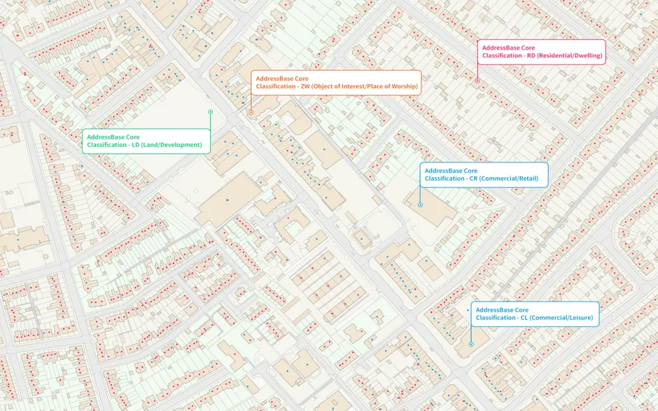
Although AddressBase Core has a simple to use data structure, it holds a wealth of information that opens it up to many use cases. Secondary level classifications (as shown in the image above) allow you to identify and filter properties at a greater granularity; for example you can find all the commercial leisure (CL) facilities within an area for specific mailshot campaigns, or you can use data analysis to find development land (LD) for utility network planning.
Feedback
We had some great user feedback during our most recent trial, with respondents particularly liking the inclusion of a new attribute called the Single Line Address. This attribute contains all address elements required to produce an address which is aligned to what you would put on an envelope. This new attribute will be specifically beneficial for use cases such as address verification and ensures customers can simply plug AddressBase Core into their systems without the need to pre-process the data.
Other positive feedback included the new easy to use formats, which includes the introduction of GeoPackage. This made it really simple to load into a GIS and be able to visualise the geometry straight-away.
"We can direct the search function to the full address column and use elastic search"
"GeoPackage is a massive win, no need to post process to create geometries"
"Much easier to load than AddressBase Premium and more instantly useable"
Within 5 minutes I had created a point layer from the data with probably most of the info we want from an address dataset"
"Removes a lot of annoying code to create geometries and filter out unnecessary data"
"I think it's brilliant – far more portable than its ancestors and efficient for accessing the vital stuff like class and single line address ... Kudos for including the GSS code – super useful."
Want to use AddressBase Core?
To find out more, visit the AddressBase Core webpage where you can see the product overview, technical information and how to get this product.

Our highly accurate geospatial data and printed maps help individuals, governments and companies to understand the world, both in Britain and overseas.
Products and solutions featured in this blog
AddressBase Core
AddressBase Core is a simple, accessible addressing data product giving plug and play access to complete, accurate address data.