Storm Ulysses – a fast and effective response to an emergency simulation, underpinned by OS data and expertise

This time, the exercise was called LIVEX Exercise Inundation: Storm Ulysses, named after a 1903 storm with some of the strongest winds on record for the British Isles.
None of the hundreds of people that took part knew the scenario in advance, or what was to come as it played out in real time on the day of the exercise, since LIVEX is designed to test the processes and protocols in place to manage real emergency events.
In the run up to the exercise, the Met Office released ‘weather reports’ about the storm and the severity of its impacts progressed, until it was elevated to a red warning. That meant, during the exercise, there was a high likelihood that ‘lives and properties would be at risk’, with the storm resulting in ‘severe coastal, river, surface and groundwater flooding, in addition to sea defence failure, high winds, property damage, evacuations and a number of other curve balls, such as a bus crash’.
"The first thing everyone wants to know is ‘where is it’? "
Ordnance Survey’s Mapping for Emergencies team, which provide geospatial insight and mapping in response to emergency situations, provided invaluable support to those making key decisions.
"I need that map in five minutes. "
Hannah Wright was joined by Mapping for Emergencies team members, including expertise from other Technical Relationship Consultants.
The team were part of local strategic and tactical coordination groups set up by the LRFs taking part in the exercise, and were also available throughout the event to support participants’ requests. At a strategic level, the team worked with the Environment Agency to ensure that maps were included within the Common Operating Picture (COP) – a real-time picture of all the information available to enable fast and accurate decision-making.
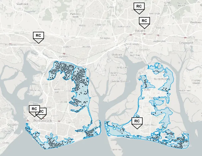
The LRFs OS supported were Thames Valley, Wiltshire and Swindon, and Hampshire and the Isle of Wight.
Hannah explained: “Requests for mapping and GIS support came in thick and fast from lots of different players. Councils wanted to know which properties were at risk of flooding and needed accurate address data to help them prepare for evacuations. We used the Environment Agency flood warning area polygons and AddressBase to quickly pull out these details and map them to give an idea of scale and how many properties might be affected. We also identified the location of hospitals, GP surgeries, care homes and schools at risk of flooding and identified safe routes for evacuation and suitable locations for Rest Centres. We had to respond and re-route as ‘curve balls’ came in throughout the day including the evacuation being brought forward, a closed bridge, and a bus crash at a critical roundabout. All of this had to be done at high speed. For example, we were given just five minutes to produce a map of the rest centres and priority routes to reach them.”
"I wouldn’t have been able to do my job without OS data and skills."
At the end of the event, the debrief acknowledged OS data and mapping as critical to the effective creation of an evacuation plan.
Hannah shared, “It was an extremely fast paced day, but it really showed how important geospatial data and mapping is in responding quickly and effectively in a time-critical event. Our data and expertise was required throughout the day to help in the decision-making process and was very much a team effort.”
OS is on call 365 24/7 for Mapping for Emergencies, available under the Public Sector Geospatial Agreement.

Our highly accurate geospatial data and printed maps help individuals, governments and companies to understand the world, both in Britain and overseas.
Products and solutions featured in this blog
OS Open Zoomstack
Ordnance Survey's OS Open Zoomstack is an open vector basemap showing coverage of Great Britain from a national level, right down to street detail.
OS MasterMap Sites Layer
OS MasterMap Sites Layer is a nationally maintained view of the detailed extents of locations like airports, schools, hospitals, utility and more.
OS Maps API
OS Maps API offers the most convenient way to add detailed OS data to your application. Benefit from unrivalled levels of detail in your GIS, web or mobile app.
OS Open Roads
An open dataset of the high-level view of the road network in Great Britain.