Times of need can inspire innovation. In 2020, North Lanarkshire Council decided to use location data in its planning processes, while helping support children to return to school and ensure they stayed safe. Inspired by an ESRI UK blog post, North Lanarkshire Council chose Ordnance Survey MasterMap data to identify pavements and paved areas for Great Britain, then used filtering for pavement types, ‘Roadside’ and ‘Path’ for example, as well as features such as footbridges, or anything deemed as ‘Roadside, Structure’.
Insights
How North Lanarkshire Council’s intelligent use of location data strengthened development and decision making
New datasets, new opportunities of analysis
| 4 minute read
Challenge
During the recovery phase of the Covid-19 pandemic, while businesses and schools were reopening, it was a new and crucial challenge to ensure people could meet the required social distancing guidelines, and help minimise the spread of infection. In summer 2020, the Scottish Government considered the concept of ‘blended learning’ – a back-up plan in case the Scottish Government or a local council needed to reduce the numbers of children in school, due to virus transmission, or local lockdowns. Blended learning would involve students learning at home, and returning to their classrooms on a part-time basis.
North Lanarkshire Council used location data, focusing specifically on pavement width, to identify wider (and therefore better) routes to maintain safe distances. Analysing such datasets could also help ease congestion at drop-off and pick-up times, and encourage active modes of transportation like walking or biking.
Through this dataset, North Lanarkshire Council could measure pavement width; specifically, determining pavements that were above or below a certain width. In this case, North Lanarkshire Council decided that any sections of pavements narrower than two metres would not be featured, and to instead focus on suitable routes that could meet social distancing requirements.

Schools were asked to provide information including school grounds, access points, and what safety measures had been implemented. The information returned varied greatly in format and content, for example some schools annotated paper maps and scanned them, while others had taken screenshots and added graphics in Microsoft Paint. Many responses were well structured, whilst others were less detailed and not always provided in a digital format. A GIS application was created to better co-ordinate the responses; introduce a consistent way of capturing necessary geometries and attribution, and ensure a clear picture of access requirements and solutions.
The mapping tool would translate existing data and diagrams into a digital map, with capability to combine additional detail and layers of information, including school entrances and waiting zones, paired with surrounding pavement width data. It could then identify any other action required, such as traffic management around narrower footpaths.
Retail: managing asset distribution
North Lanarkshire Council recognised that Ordnance Survey topographic area data had potential to be multi-purpose, not limited to educational plans but able to assist in other areas such as retail planning.
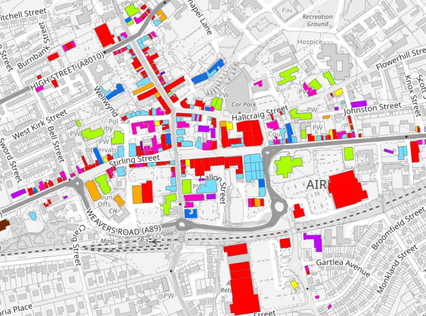
To achieve this, OS MasterMap data could be combined with other datasets such as shops and other town centre property types included in the Retail Outlets Survey (ROS). This data is used to define town centres, assess floorspace, understand vacancies, and monitor any major changes to the infrastructure.
ROS data is typically held in Microsoft Excel spreadsheet format, making it difficult to visualise, and carry out spatial analysis. North Lanarkshire Council had the idea of connecting ROS records to the OS MasterMap data; specifically, combining Building TOID (Topographic Identifier, used for every feature found in OS MasterMap products) with the ROS data.
This allowed all building shapes that were part of the ROS data to be properly plotted, and the dataset could then be used to redefine the boundaries of the town centre.
And while this is a valuable asset to have developed, this retail data would also prove useful to North Lanarkshire Council in assessing the distribution of services and facilities, when considering recent policy changes such as defining 20-minute neighbourhoods.
Outcome
The initial use of location data by North Lanarkshire Council would help reduce the risk of transmission, and ensure that students could safely return to school, while observing social distancing guidelines.
But the council recognised that the concept can be applied to other situations; and has been already, benefiting both education and retail. North Lanarkshire Council has created a dataset with the capability to analyse pavement widths, that could reach new possibilities of data analysis. North Lanarkshire Council’s creation can help inform urban planning, with analysis into traffic, safety, cost, accessibility, and mobility. An interactive map, with secure interconnectivity of data and OS products, and multiple users, which could inform the development maintenance of pavements, greenspaces, cycle lanes – whatever is needed.
North Lanarkshire Council has made intelligent use of location to the benefit of its own development and decision making, by building a platform on which they can add other datasets, with the scalability to unlock new, valuable insights.

By Ordnance Survey
Our highly accurate geospatial data and printed maps help individuals, governments and companies to understand the world, both in Britain and overseas.
Register your organisation for the PSGA
Public sector organisations can start making full use of OS data and services when they register for the PSGA
Products and solutions featured in this insight
OS Open TOID
A dataset of unique identifiers for a wide range of land-scape and built environment features with a generalised location from OS MasterMap products.
OS Open UPRN
An open dataset enabling linking, sharing and visualisation of data related to UPRNs.
OS MasterMap Topography Layer
OS MasterMap Topography layer provides a map dataset of Great Britain's landscape – from roads to fields, to buildings and trees, fences, paths and more.
OS MasterMap Highways Network - Paths
A path network dataset for Great Britain showing who is responsible for all the footpaths through towns and cities.