Building resilience to respond to extreme weather events
Emergency responses are often required for unprecedented events, even with extensive planning protocols in place. Geospatial data can be used as a vital source of intelligence in these responses, providing a common operating picture by combining different emerging information about a situation through a shared location component. Notably, this allows for precision in planning activities and rescue efforts, especially in instances when multiple agencies are collaborating. However, while it is well understood that such high quality geospatial data and sharing is crucial for understanding and reducing local disaster risks, Ordnance Survey research and pilot implementations have shown that many countries around the world can improve how they maintain and share accurate geospatial data sets to support intelligent-driven approaches to building local resilience.
This can be rectified, as reflected in our work with the Greater Manchester Local Resilience Forum, when flooding in Greater Manchester, UK, in early 2021 triggered a series of escalating processes that led to a need for Ordnance Survey support. We conducted geospatial analysis to map properties, critical and vulnerable infrastructure and transport hubs at risk from flooding. With the risk to property and life, OS supported the customer to manage a fast-evolving data landscape, ensuring that the multiple parties involved – from local authorities to police and emergency services – had access to actionable and accurate geospatial information.
Similarly, major disruption was caused in the North of England in 2018 by the 'Beast from the East' snow storm in Cumbria, UK, cutting off many rural communities for several consecutive days. The depth of the snow and challenging mountain and moorland terrain resulted in significant issues accessing some communities. Cumbria’s multi-agency Strategic Co-ordinating Group (SCG), made up of partner agencies, secured military assistance to help access the most isolated communities.
To provide assistance during this time, OS supported the response through the public sector initiative Mapping for Emergencies (MfE). The MfE service, available under the Public Sector Geospatial Agreement (PSGA), provides geospatial advice support (both on-site and remotely) during any emergency or major incident, whether it's responding to natural disasters, missing person searches, public health crises or security threats.
In this case, military assistance was provided with teams working day and night to reach the isolated communities. A Chinook helicopter performed airdrops, taking emergency supplies to those who needed them most. Priority areas to supply drops were identified with mapping and data exchange support that OS provided.
While many responder agencies operate their own mapping and geospatial capabilities, coordination groups ensure that data is shared during major incidents for maximum situational awareness and impact. One of the key challenges in responding to emergencies is access to accurate location data about people and places often in near real time. Therefore, data sharing is one of the biggest challenges to delivering resilience. Barriers to sharing information in an emergency include policy, information security, technology issues and data compatibility issues which can prevent data being shared effectively between departments or organisations.
In the United Kingdom the ResilienceDirect maps service provided by the Cabinet Office brings together authoritative geospatial data such as base mapping, address data, environmental data and event data into a single easy to use service together with tooling to support the resilience community. This secure service which is free at the point of use is an excellent example of how community leadership and centralised funding and management can create a multi-agency capability which elegantly overcomes the barriers and issues around data sharing and access.
By establishing authoritative, accessible geospatial information, policies and processes, such as those described by the United Nations Committee of Experts on Global Geospatial Information Management, and deploying them with appropriate expertise, government can better join-up those who have the data available and those who need it to enable better, more rapid decision making. Geospatial information can then be used to deliver a common operating picture which serves as a framework through which data about people, places and impacts can be rapidly assembled, combined and shared. Lack of data access in emergencies potentially poses a real risk to life, critical infrastructure, industrial assets and property, when a time critical response is required.
Several intergovernmental organisations such as the UN, World Bank and the OECD have active programmes focusing on the invaluable role that location-based information has on national, regional and global development, especially in emergencies. Even countries with robust disaster risk management programmes in place can still be highly exposed to the economic and fiscal shocks caused by major disasters.
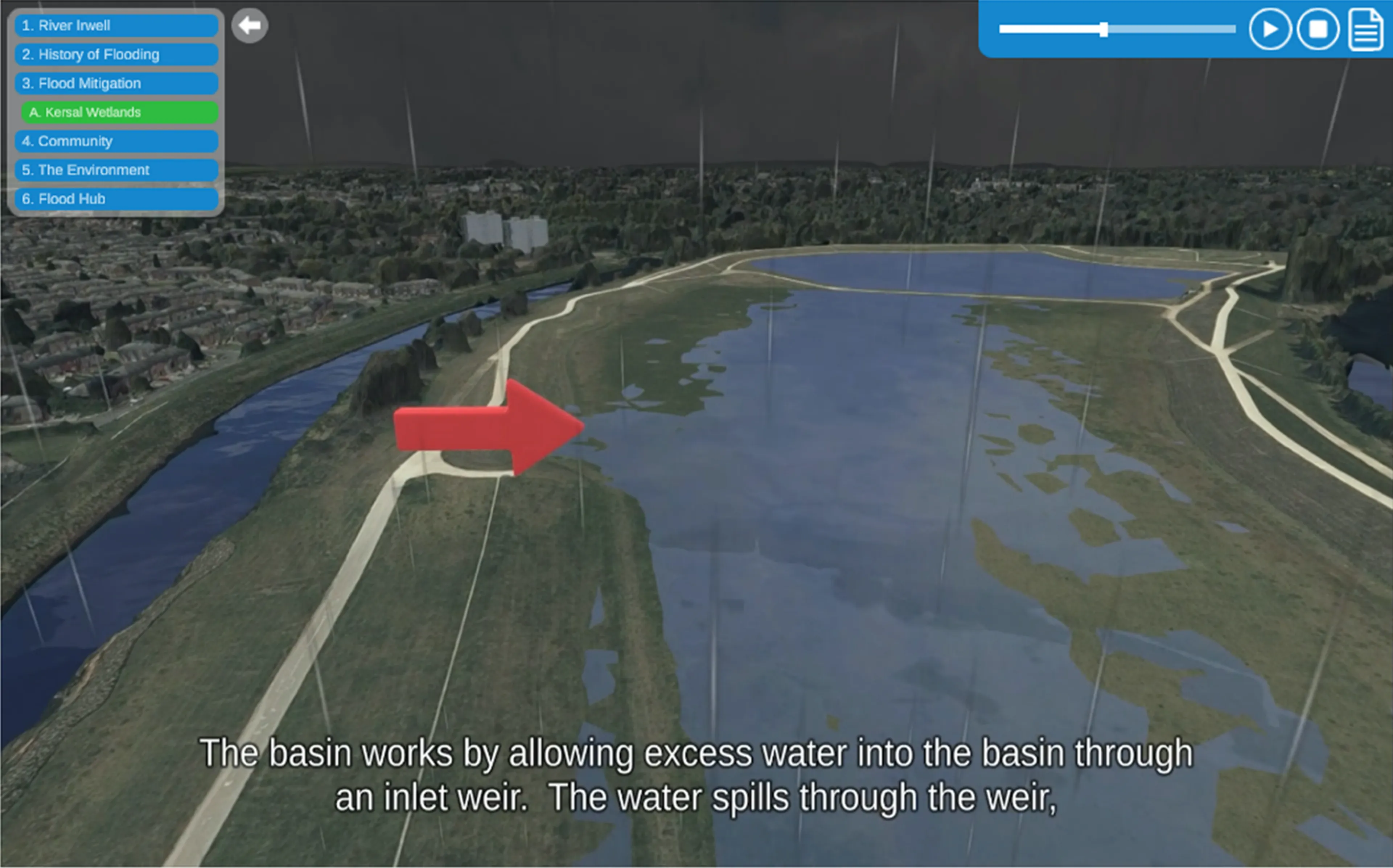
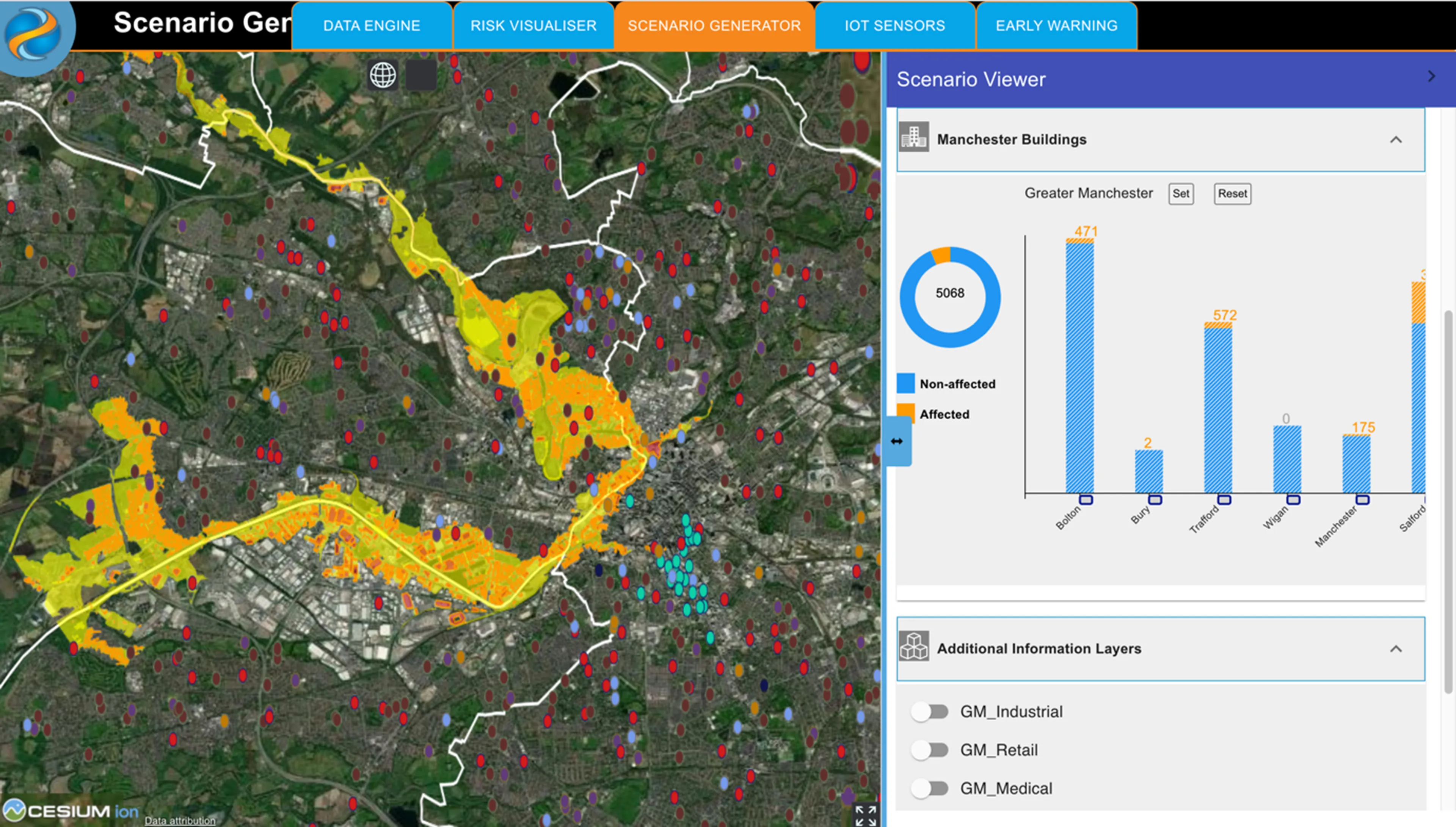
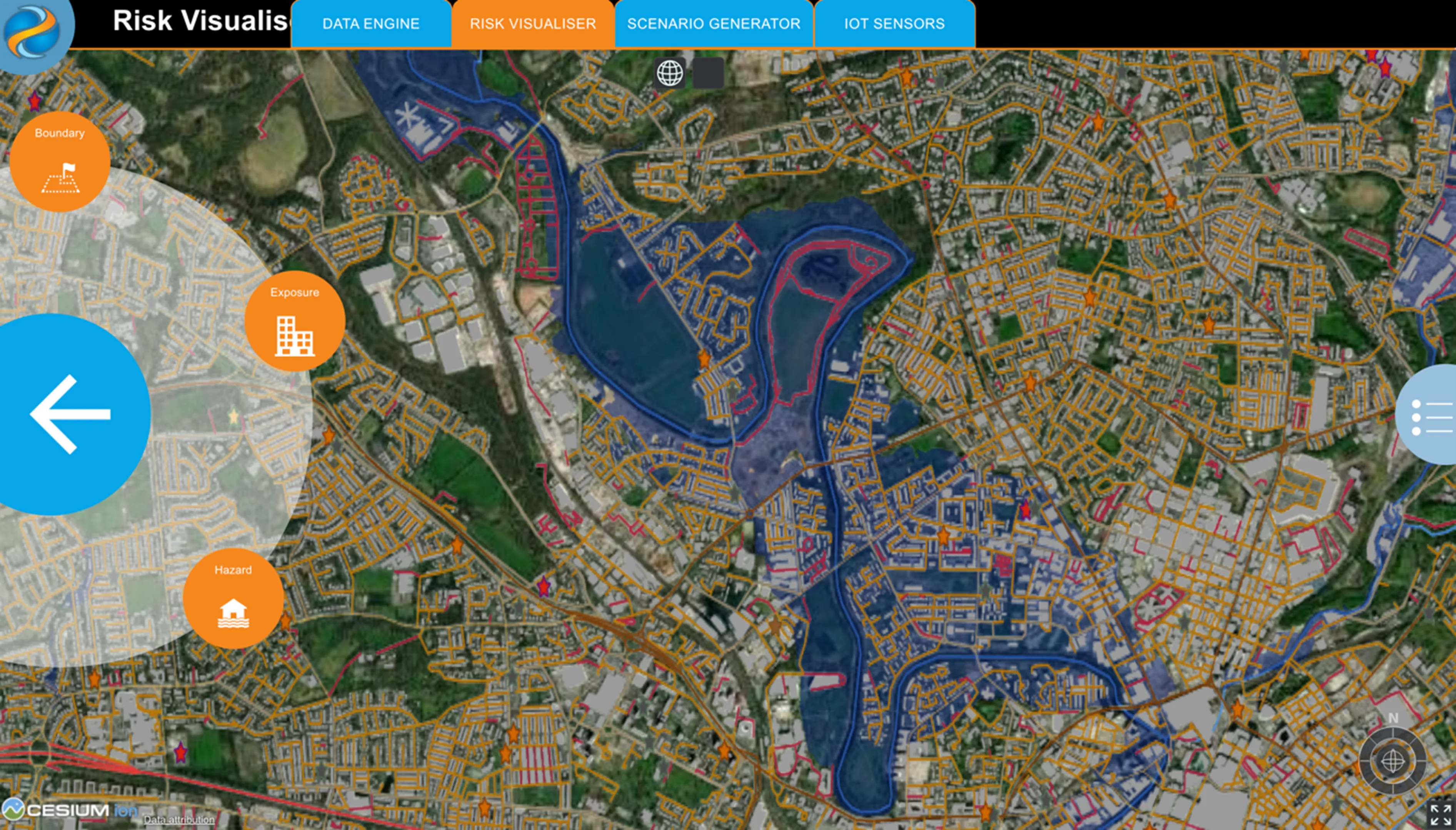
In an international and developing world context, the MOBILISE platform, developed by the University of Salford’s THINKlab, gathers information from Earth Observation groups, river sensor networks, real-time weather information services, hazard simulation services, and local communities to present data in an innovative virtual collaborative environment, so establishing a common operating picture during a disaster. MOBILISE helps the multiple agencies involved in an emergency capture a highly accurate picture of an incident and manage their response accordingly. The platform is capable of mapping social, infrastructure, economic and natural vulnerabilities for a defined hazard or set of hazards, allowing agencies to work together to reduce such vulnerabilities and build resilience. It can also be used to understand the cascading impact of hazard events on networked critical infrastructure, the community and the economy.
Commenting on Ordnance Survey’s work with Greater Manchester Resilience Unit and the University of Salford to support a Local Resilience Forum Innovation Pilot Project funded by the Department of Levelling Up, Housing and Communities (DLUHC), Professor Terrence Fernando, Director of THINKlab at University of Salford, said:
"Ordnance Survey is a global exemplar of best practices on how geospatial data should be prepared and shared among agencies to help build local resilience. Thanks to the availability of data from Ordnance Survey, with MOBILISE we were able to demonstrate how the value of geospatial data can be realised for collaborative resilience building, community engagement and multi-agency training and exercises and inspire other government agencies around the world."
Platforms such as MOBILISE demonstrate the power of geospatial data in responding to natural disasters and extreme weather emergencies, all of which will become more frequent and destructive with climate change. By coordinating relevant parties and merging information rapidly via authoritative mapping expertise, effective decisions can be made and lives protected.
Another advantage of MOBILISE is its ability to run possible hazard scenarios before they actually happen to get a measure of the devastation they can cause and identify pre-emptive actions to reduce their impact on the built and natural environment. Such scenario planning can help to strengthen multi-agency training for disaster response, implement resilient building programmes, and install early warning systems for the most vulnerable communities. It is the key to building a more resilient society to respond to emerging climate-induced threats.
MOBILISE Community Engagement Environment for Presenting Disaster Risk Reduction Strategies

MOBILISE Scenario Planning Environment for Reservoir Breach

Principal Consultant at Ordnance Survey
Discover how geospatial data can make your country more resilient
Read more about how geospatial data can help your nation build resilience to natural and human threats in our See a Resilient Nation report.
Find more Insights
- Security and emergency
- Infrastructure
- Natural environment
- International government
- PSGA members
- Government and public sector
- Middle East
- Great Britain
- United Kingdom