Geovation Scotlands’s EOLAS Insight are the first UK company to detect animals using satellite imagery
In recent weeks, EOLAS Insight, part of Geovation Scotland’s 2021 alumni, have hit the headlines for taking the lead in a project using cutting edge technology to help conservationists count African elephants from space.
EOLAS Insight are a Glasgow based environmental tech company comprised of geographic information systems (GIS) specialists, data scientists, satellite data analysts and general technologists. But their path into tracking animals from space was all a little fortuitous, as Doug McNeil, EOLAS Managing Director, explains.
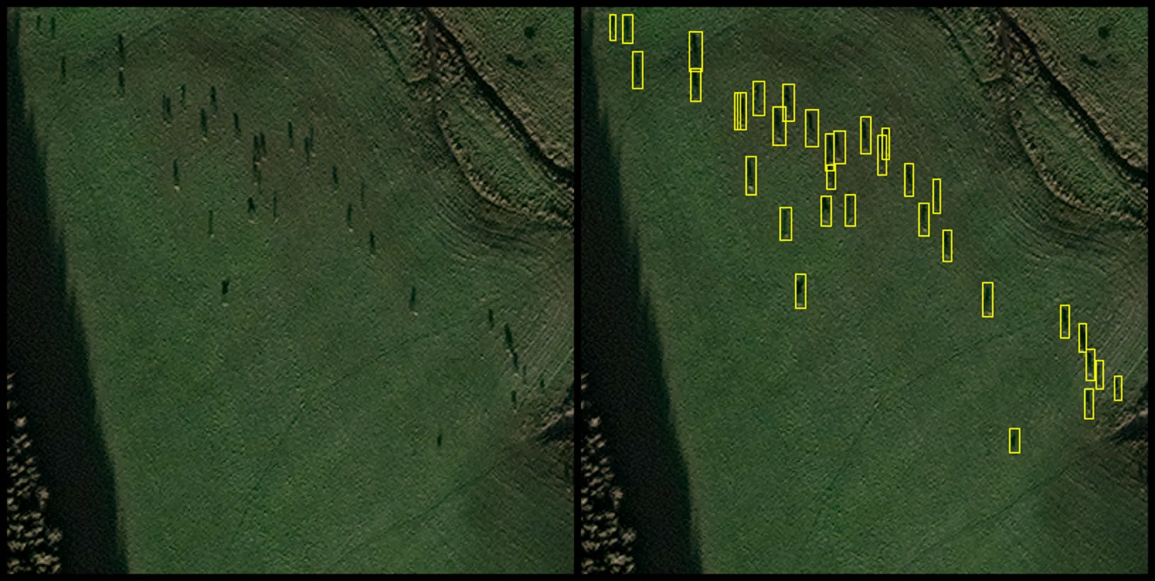
“We were conducting a drone survey in Scotland, and we were asked to support a deer count, but we realised there was a problem pretty quickly. Traditionally people walked massive estates to do ground counts but even with a drone it was not ideal.
“Being from the space sector we looked to see if satellite tech would be more suitable. We knew that new and more suitable constellations came online at 30cm resolution, so we got in touch with NatureScot and got a place on CivTech and the rest is history.”
Off the back of their successful work counting Scotland’s wild red deer, they are now working with partners The Peace Parks Foundation under funding from the European Space Agency to conduct animal censuses using satellites. They are using artificial intelligence (AI) and high-resolution satellite imagery to detect elephants roaming across vast areas of a National Park in Southern Mozambique.
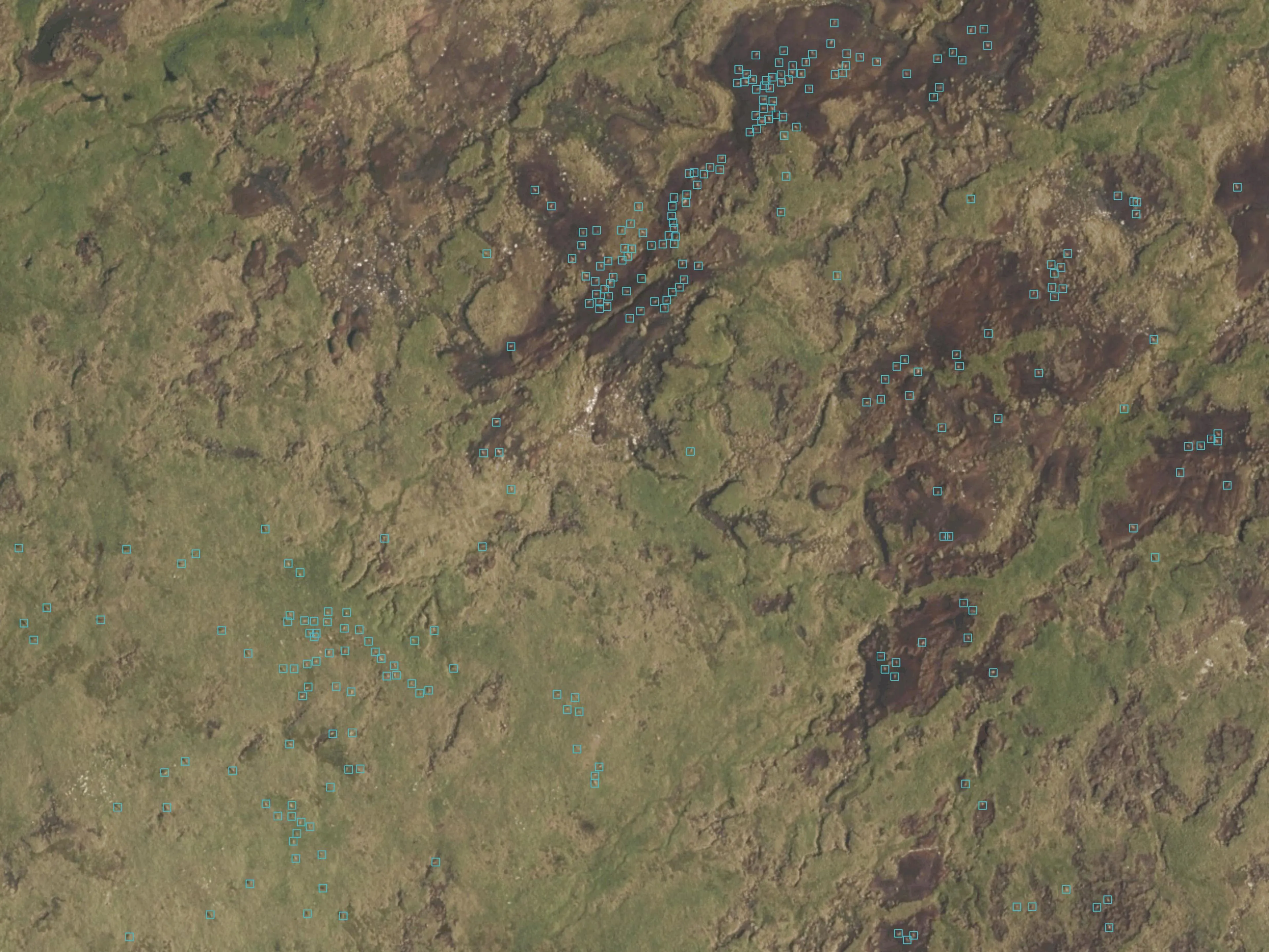
This innovative approach could vastly improve the monitoring of threatened elephant populations across a wide range of habitats. The data EOLAS helps to collect is also used to classify the animals’ habitats and identify potential risks such as the likelihood of wildfires. As the technique does not depend on people on the ground, it can be used in remote areas, supporting efforts such as counter poaching.
Doug continued: “Technology can play a key role in tackling what is arguably the biggest challenge facing humankind - conservation and the climate crisis. Detecting animals in satellite imagery will have its place in preservation projects of the future, and we are incredibly excited to be the first UK company to demonstrate this capability.”
But they are not finished there, as Doug explains: “Now that we have refined this process by working closely with NatureScot to develop satellite imagery to track animals we will look to continue to develop this on a larger scale and work in new markets with this proven technology.
“In future, through work with the Geovation Scotland programme run by Registers of Scotland (RoS) and OS, we will create a web-based platform allowing the user direct access to our algorithms.”
EOLAS joined the Geovation Scotland Accelerator Programme in 2020, primarily to create and work on their web-based platform. Within that portal OS data is fundamental to data visualisation and analysis as well as forming the base mapping layers within the tool. An added bonus is that land managers, who are their target audience, are generally very comfortable using OS land management products.
The tool is now at a prototype stage and EOLAS are hoping to launch their cloud-based machine learning tool for the detection of animals and peatland restoration shortly. They are also working on automated natural capital reports, environmental cost analysis and fire risk mapping.
“There are so many hugely powerful new technologies available for environmental professionals and ecologists, however accessing these technologies can be a job in itself. At EOLAS we want to take the complexity out of technology and provide invaluable information to our customers. Our hope is that we can help them in some small way in their hugely important and timely work.
“Geovation Scotland has been instrumental in developing our company over the last six months. The personalised and community support has allowed the acceleration of our services and facilitated engagement with the geospatial community, as well as Scottish governmental departments and Location Data Scotland.
“We have done a number of accelerator programmes, but Geovation Scotland was not only a positive experience, it has been game changing one too,” concluded Doug.
Geovation’s Accelerator Programme, which is also supported and funded by HM Land Registry (HMLR) in England and RoS in Scotland, provides start-ups with a bespoke package of financial support which includes equity-free grant funding, a 12-month residency in the data hub (6 months of which includes intensive support from industry experts), workshops, coaching and access to cutting edge data from OS and HMLR.
Geovation supports start-ups from their hubs in London, Edinburgh, Bristol, Cardiff, Birmingham and Manchester. Since 2009, Geovation and Geovation Scotland have supported over 150 location-data and PropTech start-ups through their Accelerator Programmes and those start-ups have created over 1,775 jobs and raised more than £116m.
Carly Morris, Head of Geovation, said: “Our mission is to bring innovations and disruptors together to create a driving force that leads the charge in geospatial innovation because we know that innovation and fresh ideas have a positive impact on people, the planet and profit.
“The next generation starting out in employment and business do not want to be a part of the problem. They want to know they are a part of the solution, part of the change required, working for purposeful businesses, creating positive impact and value.
“EOLAS Insight epitomises this, and we are really proud of the work they have done. We look forward to working with them in the future.”
Access the links for more information on the Geovation Accelerator Programme and EOLAS Insight.
Sharing the latest news about OS. We can license you to use OS maps in print, online and film format. For more information and resources for journalists, bloggers and media professionals, email pressoffice@os.uk or call 023 8005 5565.
Find more blog articles
- Natural environment
- Innovation
- Sustainability
- Developers
- Businesses
- PSGA members
- Partners
- Great Britain