Overview
- Type of mark
- Surface Block
- Flush bracket
- Not Available
- Grid reference
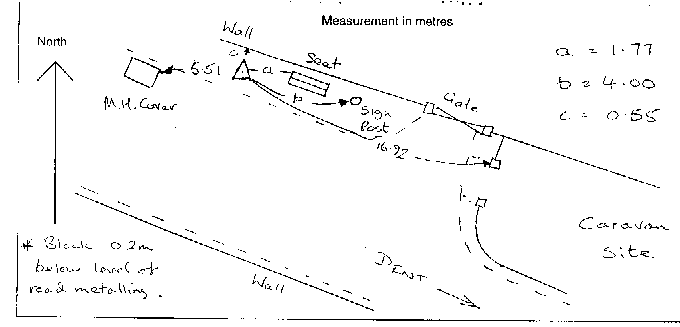
- SD702873
- Access to mark
- 2WD Vehicle
- Keys required
- No
- On Landranger sheet
- 98
Click to buy - On Explorer sheet
- 2
Click to buy - Permission required
- No
Coordinates of this station
ETRS89 Cartesian
- X
- 3728591.8340
- Y
- -160157.9401
- Z
- 5155171.9588
ETRS89 Geodetic
- Latitude
- N 54 ° 16' 49.296005"
- Longitude
- W 2 ° 27' 34.455895"
- Ellipsoid height
- 181.582
National Grid (Transformed by OSTN15/OSGM15)
- Eastings
- 370175.333
- Northings
- 487287.499
- Height
- 129.482
NB: If 'permission required' is Yes at top of this form, the land owner or agent's permission must be obtained before accessing the mark.