Britain’s highest and lowest roads revealed
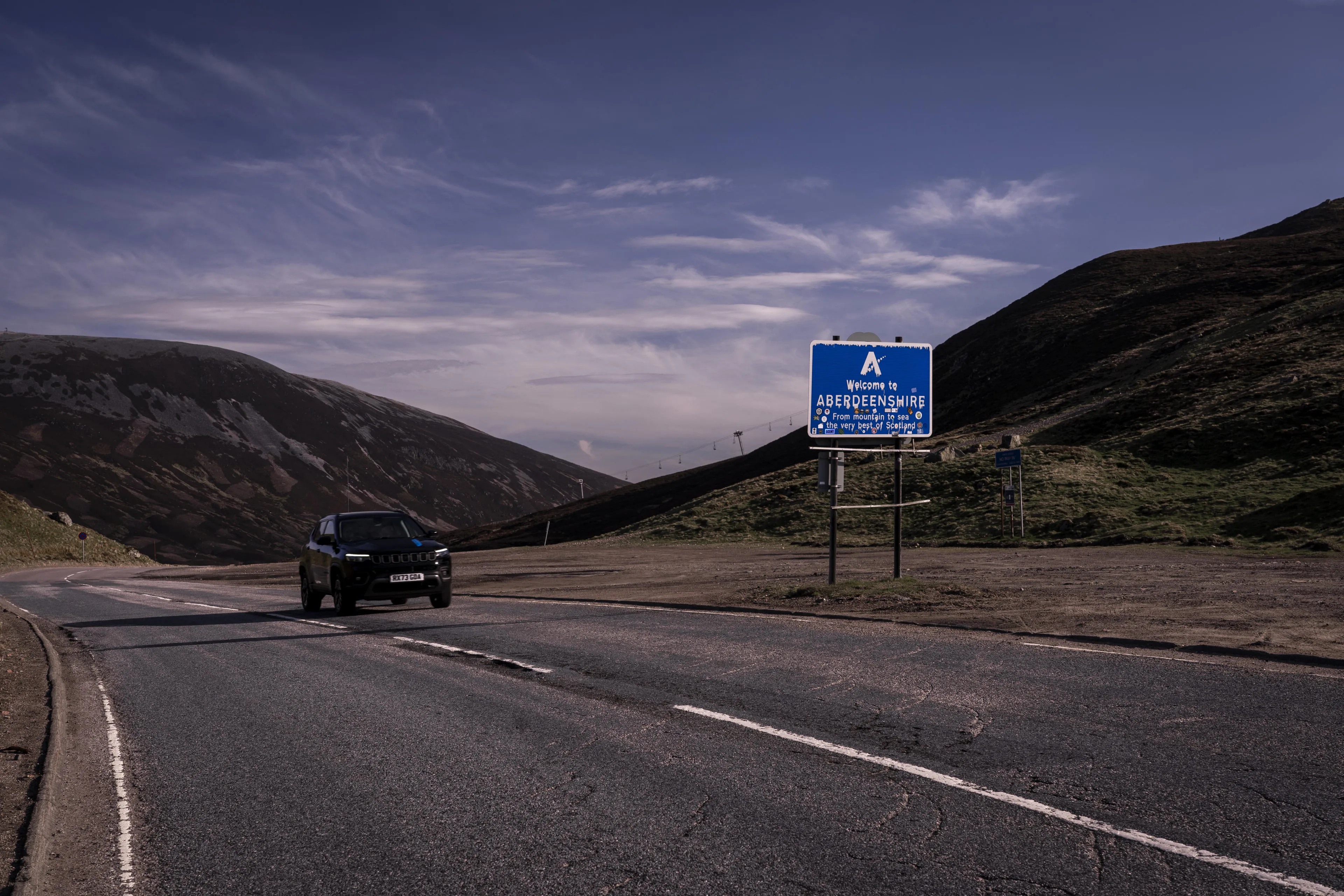
Old Military Road in Cairnwell Pass, Scotland, tops the list of highest roads at 668 metres/2,192 feet above sea level according to OS, while all Britain’s lowest roads feature in Cambridgeshire’s Fenlands.
Press Office
Data found that the A93 ‘Old Military Road’ in Cairnwell Pass, Scotland, between the picturesque village of Braemar in Aberdeenshire and the hilly Spittal of Glenshee in Perth and Kinross, takes the top spot as Britain’s highest elevation road at an incredible 668 metres/2,192 feet above sea level.
The data was sourced from OS’s MasterMap (OSMM) Highways Network and only includes roads in Great Britain that are publicly accessible by car. Elevation heights were calculated from the apex point of each road in the country.
The Old Military Road is part of a network of routes across the Scottish Highlands, built in the 18th century, as well as being home to several spectacular hydroelectric dams.
Lecht Pass in Aberdeenshire and Cairngorm Mountain Road in the Scottish Highlands rank in second and third place, at 643 metres/2,110 feet and 635 metres/2,084 feet above sea level respectively.
The highest public road in England was identified as the Harthope Moss mountain pass, a steep road elevated at 630 metres/2,067 feet above sea level and located between St John’s Chapel and Langdon Beck, Durham.
The highest-elevation major road was unveiled as the A689 Killhope Cross between Cowshill, Durham and Nenthead, Cumbria at 626 meters/2,054 feet above sea level.
In contrast, the lowest-elevation public roads in Great Britain can all be found in The Fenlands, Cambridgeshire, England – ancient marshlands known for their rich ecosystem – alongside the lowest point in the whole of Britain. Seven roads in The Fenlands sit at three metres/10 feet below sea level including Holme Fen, New Long Drove, Fourth Drove, Third Drove, Second Drove, North Fen and Adventurer’s Drove.
The lowest-elevation major road in Britain is the A1101 Mildenhall Road – two meters/6.5 feet below sea level – between Littleport and Shippea Hill Station, Cambridgeshire.
Kris Cholmondeley, Managing Director at Jeep UK, said: “At Jeep, we’re always looking for a sense of adventure on our Great British roads. In partnership with Ordnance Survey, we’ve pinpointed the highest and lowest public roads which happen to be in some of the most picturesque regions. I really encourage you to give them a go.”
Nick Giles, Managing Director for Leisure at Ordnance Survey, said: “If you are planning on taking a trip to any of these notable locations around Britain – whether it’s the highest public roads in the country or the lowest – why not park up, pull out your OS map or OS Maps app on your phone, and explore the area. Trips like these create adventures to remember.”
Top 10 Highest Roads in the UK:
|
Rank |
Road Name |
Elevation (above sea level) |
Location |
|
1. |
Cairnwell Pass, A93 Old Military Road |
668m/2,192ft. |
Ballater, Scotland, between Braemar, Aberdeenshire (NO 15195 91470) and Spittal of Glenshee, Perth and Kinross (NO 11081 70207). |
|
2. |
Lecht Pass, A939 |
643m/2,110ft. |
Strathdon, Scotland, between Tomintoul, Moray (NJ 16949 18633) and Cock Bridge, Aberdeenshire (NJ 25725 09208). |
|
3. |
Cairngorm Mountain Road |
635m/2,084ft. |
Aviemore, Scotland, between Coylumbridge, Highland (NH 91587 10752) and Cairngorm Mountain, Highland (NH 99008 05965). |
|
4. |
Bealach Na Bar |
630m/2,067ft |
Strathcarron, Scotland, between Tornapress, Highland (NG 83766 42177) to Applecross, Highland (NG 71222 44565). |
|
5.
|
Harthope Moss (highest in England) |
630m/2,067ft |
Bishop Auckland, England, between St John’s Chapel, Durham (NY 88452 37696) to the junction with the B6277 west of Langdon Beck, Durham (NY 84886 31679). |
|
6. |
Killhope Cross, A689 (highest A-Road in England)
|
626m/2,054ft |
Alston, England, between Cowshill, Durham (NY 8560540592) and Nenthead, Cumbria (NY 78116 43724). |
|
7. |
Coalcleugh Moor |
609m/1,998ft |
Hexham, England, between Thornley Gate, Northumberland (NY 83177 56221) and junction with A689 east of Nenthead, Cumbria (NY 78939 43422). |
|
8. |
Black Hill |
607m/1,992ft |
North Pennines, England, between Westgate, Durham (NY 90450 38014) and Newbiggin, Durham (NY 91451 27754). |
|
9. |
Tynehead Fell |
599m/1,965ft |
North Pennines, England, between Garrigill, Cumbria (NY 74924 42139) and Langdon Beck, Durham (NY 85342 31216). |
|
10. |
Nunnery Hill |
599m/1,965ft |
Cumbria, England, between A689 Nenthead, Cumbria (NY 78116 43724) and B6277 Garrigill, Cumbria (NY 74924 42139). |
Top 10 Lowest Roads in the UK:
| Rank | Road Name | Elevation (below sea level) | Location |
|
1. |
Holme Fen |
-3m/-10ft |
Cambridgeshire, England, between junction with Hod Fen Drove (TL 19429 88539) and Old Pumphouse (TL 23555 90389). |
|
2. |
New Long Drove |
-3m/-10ft |
Cambridgeshire, England, between junction with B660 Long Drove (TL 21204 88131) and junction with Holme Fen (TL 22180 90161). |
|
3. |
Fourth Drove |
-3m/-10ft |
Cambridgeshire, England, from junction with Main Drove (TL 52360 86559) and end of road (TL 52865 87080). |
|
4. |
Third Drove |
-3m/-10ft |
Cambridgeshire, England, from junction with Main Drove (TL 52546 86146) and end of road (TL 53786 87413). |
|
5. |
Second Drove |
-3m/-10ft |
Cambridgeshire, England, from junction with Downham Common (TL 52649 85637) and end of road (TL 54160 87181). |
|
6. |
North Fen |
-3m/-10ft |
Cambridgeshire, England, from junction with California / Brickkiln Lane (TL 53247 84387) to end of road (TL 54241 85754). |
|
7. |
Adventurer’s Drove |
-3m/-10ft |
Cambridgeshire, England, between junction with B1411 (TL 50306 84855) and Oxlode (TL 48533 86216). |
|
8. |
A1101 Mildenhall Road
|
-2m/-7ft |
Cambridgeshire, England, between A10 near Littleport, East Cambridgeshire (TL 57915 87710) and Shippea Hill Station (TL 64204 84104). |
|
9. |
B1160 Feltwell Road |
-2m/-7ft |
Cambridgeshire, England, between Southery, Norfolk (TL 62074 94815) and Decoy Road (TL 64770 94247). |
|
10. |
B1104 Prickwillow Road
|
-2m/-7ft |
Cambridgeshire, England, between Prickwillow, East Cambridgeshire (TL 59249 82267) to Isleham, East Cambridgeshire (TL 64215 74666). |
Sharing the latest news about OS. We can license you to use OS maps in print, online and film format. For more information and resources for journalists, bloggers and media professionals, email pressoffice@os.uk or call 023 8005 5565.
Explore OS Maps
You can share your walking, cycling or running routes in Great Britain by downloading the OS Maps App on your phone, PC or laptop
Find more news
- General public
- Consumer
- Great Britain
- United Kingdom