Challenge
Bolton-le-Sands Parish Council wanted to address ongoing traffic and parking issues around a local primary school, with particular concerns around school drop-off and pick-up times.
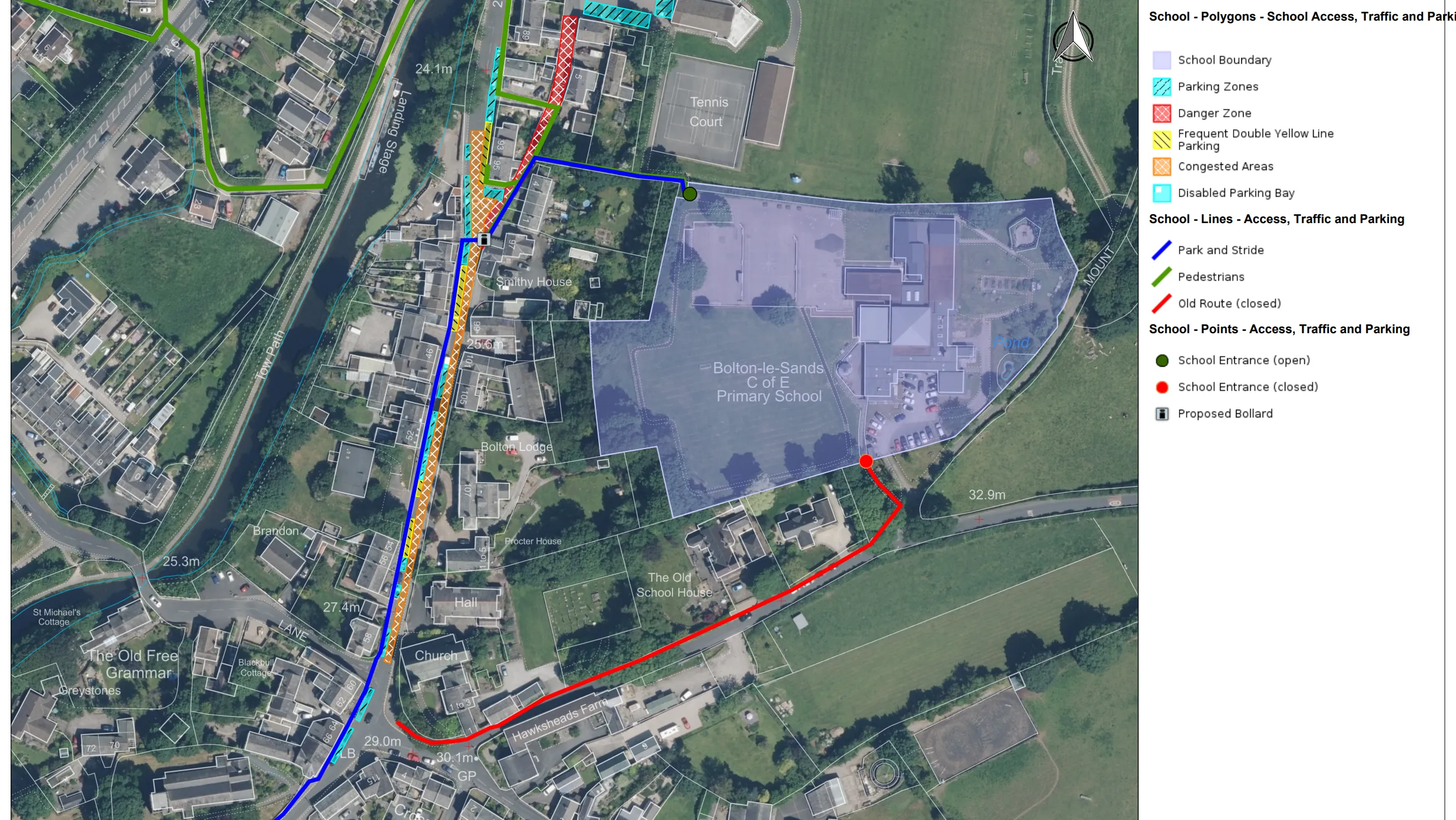
Road closures and diversions concentrated foot and vehicle traffic to a single access point, resulting in vehicles mounting the narrow pavement and blocking access for pedestrians. Children and carers then had to walk around parked cars and on non-pavemented areas, leading to greater congestion and safety risks during school hours.
Parking violations, particularly on yellow lines, also posed safety hazards and contributed to the congestion by reducing traffic to a single lane.
Solution
Bolton-le-Sands Parish Council wanted to use mapping and location data to create a solution that was informative, educational, and would provide greater spatial awareness, therefore enabling more effective council planning. The Council recognised that there are numerous mapping solution providers to choose from, but selected Parish Online as it most effectively met their needs.
Parish Online is a service provided by Geoxphere Ltd, a Partner with Ordnance Survey (OS), and is specifically designed to serve local councils. It is a digital mapping solution for town, parish, and community councils across England, Wales, and Scotland, which provides the data and tools necessary to carry out Neighbourhood and Local Place Plans, assess planning applications, and manage assets.
Bolton-le-Sands Parish Council appreciated Parish Online for its wide range of pre-loaded mapping and easy-to-use drawing and print tools, making it the ideal choice. It enabled the Council’s decision making, and provided insight to the local community.
As a member of the PSGA, the Council used Parish Online mapping to analyse traffic flow through roads, access routes and footpaths. This provided a clearer understanding of the situation and the Council created a detailed map highlighting these key areas of concern. An example of Parish Online mapping is shown below:
Result
With Parish Online, Bolton-le-Sands Parish Council created an interactive online map that is live and accessible to the public, helping residents identify and better understand safety issues. With reminders to the local community and the opportunity to leave feedback, the Council is in a strong position to support safer routes to school and deliver effective changes that benefit all residents. Any personal data submitted as part of community feedback is handled in accordance with the Council’s privacy policy and UK GDPR.
The Council secured key stakeholder engagement by highlighting traffic and parking issues near the school. The maps and visuals generated through Parish Online were instrumental in briefing local MP Lizzi Collinge, who noted that they helped her understand the location and nature of the safety concerns before her visit.
The Council continues to engage with stakeholders and promote safe access initiatives in partnership with the school and broader community.
Benefits
The Parish Online platform served as a useful planning tool, enabling the Council to share key announcements with the community via its website. For example, the Parish Online platform served as a useful insight and planning tool to address traffic and parking issues, and is also enabling the Council to share key announcements. During the Remembrance Sunday procession in November 2024, the online map showed public access routes, marked road closures, and highlighted important landmarks such as buildings and the war memorial.
The Parish Online mapping tool also provides opportunity for additional use cases. Bolton-le-Sands Parish Council could implement additional layers of data and detail, much like the layers with buildings and roads. Other datasets such as tree works and Tree Preservation Orders, asset management, and other OS datasets, could help to build an even more intricate depiction of Bolton-le-Sands, unlocking new levels of insight, and further benefiting assessments and planning.
Partners and PSGA
Parish Online is a solution provided by Geoxphere, an OS Partner that specialises in supporting town, parish and community councils with cost-effective mapping software for asset management, neighbourhood plans and other mapping needs. It also provides GOV.UK websites and email. Explore our 'Find an OS Partner' page.
Local councils like Bolton-le-Sands Parish Council can start making full use of OS data and services, and Parish Online software, if they are registered with the PSGA. Discover how to register below.