How the Welsh Government is leading the way with a single mapping and data platform for Wales
The portal is supported by trusted data from Ordnance Survey
Press Office
From empowering the public with transparent access to detailed information - ranging from speed limits to the location of public toilets - to supporting local authorities in decision-making, DataMapWales plays an essential role across Wales. Most importantly, the portal is also providing near real-time information to the resilience community, planning for, and responding to, emergencies such as landslides or flooding.
OS data is integral to the portal, which first started out as an environmental tool for the Welsh Government more than ten years ago. It makes full use of 35 OS datasets, such as OS MasterMap Topography Layer and OS AddressBase, available to the public sector under the Public Sector Geospatial Agreement. Datasets such as OS NGD Buildings and OS NGD Address from the OS National Geographic Database are in the process of being made available in the portal with more to follow.

Today, DataMapWales is being used in a raft of different ways, most commonly to support active travel. The website hosts over 3,000 datasets, 600 of which are open data and can be directly accessed by the public. It is able to host public consultations, most recently on Welsh language place names. Beyond this, DataMapWales provides data in areas such as EV charging, carbon calculation scenario modelling and assessing how changes to land use affect carbon emissions and carbon storage potential. Last year, data from the portal was also used to support the publication of the Welsh Index of Multiple Deprivation, to identify areas experiencing higher levels of deprivation.
"DataMapWales is constantly evolving. Looking after a smaller country, we are able to work in a very agile way in terms of what we are delivering and how the portal is used. Ordnance Survey data provides the backbone of DataMapWales and is key to the success and effectiveness of the platform."
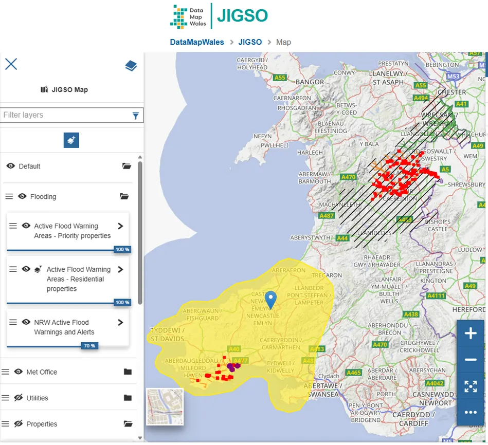
Perhaps most critically, the DataMapWales team is developing a bespoke application – Jigso - to support the resilience community in Wales. With severe flooding expected to occur more frequently across the country as a result of climate change, this will be critical for emergency responders.
The majority of the emergency service, responder agencies and resilience organisations across Wales are already signed up to the application and can access and download its data. The team is hoping to encourage utility companies and organisations to securely share their data so Jigso has the ability to identify vulnerable people using a broader range of information sources. By using Unique Property Reference Numbers (UPRNs), Jigso links essential data to specific properties, helping agencies quickly identify and support those most in need.
While Jigso is still in development, it was used to calculate the number of vulnerable households affected by the flooding in Monmouthshire last year, helping the emergency services reach those who needed help more quickly. By combining OS data with other datasets, Jigso provides the spatial accuracy needed for emergency services to respond quickly and effectively. The Welsh Government has provided additional funding to further develop the Jigso application into a fully supported product.
Stuart Townsend, Group Manager at South Wales Fire and Rescue Service explained:
"During the recent flooding in Monmouth, we were able to use Jigso via DataMapWales, drawing on Ordnance Survey data, to quickly identify vulnerable households within flood-risk areas. This enabled fire crews, working alongside partner agencies and the voluntary sector, to carry out targeted visits to check on the welfare of residents.
"By using this approach, we were able to deploy our resources in a far more focused and effective way. Through Tactical and Strategic Coordinating Group meetings, we were also able to provide timely, informed updates to our partners. Previously, gathering this level of information would have taken a considerable amount of time. Now, it can be accessed within minutes, enabling faster, better-informed decision making during incidents."
Pam Whitham, Customer Development Manager at OS, added:
“We have had a very close relationship with the Welsh Government for many years and are delighted that it continues to use OS data extensively, particularly in DataMapWales. This is a fantastic portal where public sector and service providers across the country are able to access trusted and authoritative data to support their routine and critical services.”
You can visit DataMapWales here: Home | DataMapWales and Hafan | MapDataCymru.
Sharing the latest news about OS. We can license you to use OS maps in print, online and film format. For more information and resources for journalists, bloggers and media professionals, email pressoffice@os.uk or call 023 8005 5565.
Explore the OS National Geographic Database
A single store of our authoritative data for Great Britain
Find more news
- Government and public sector