Ordnance Datum Newlyn - 100 years old
Located near one of the UK's busiest fishing ports, you'll find the Newlyn Tidal Observatory – the home of mean sea level for mainland Great Britain
The home of mean sea level
Located at the end of one of the UK's busiest fishing ports, you'll find the unassuming Newlyn Tidal Observatory – the home of mean sea level for mainland Great Britain.
Sea level was measured using averages of readings taken using a device known as a tide gauge. Used in ports and harbours worldwide, tide gauges record the heights of the rising and falling tides.
100 years ago, on 30 April 1921, sea level recording here by OS was concluded after six years of measurement. Within these six years, the Newlyn tide gauge took hourly readings.
Conducting and recording these measurements over a set period of time enabled a mean sea level “datum point” to be established, and every height measurement in the country has been determined based on the work of this machine. The resulting height datum is known as Ordnance Datum Newlyn (ODN) and marks height zero on maps in Britain.
In addition, the difference in height from this point to any other fixed location can then also be determined. Spreading out across the country are lines of levelling observations recording the changing height (related back to zero at Newlyn). The many thousands of familiar benchmarks left behind on these lines are permanent markers of a given height above ODN (find out more).
There are many different types of tide gauge, but their design can be quite simple, consisting of a float that sits on top of water in a tube. The gauge worked by recording the rise and fall of the sea, and the variations were recorded on paper attached to the rotating drum suspended from its centre.

ODN
Did you know, how we calculate the height above sea level has a direct impact on the heights of mountains and hills and the depth of valleys? ODN is the level chosen to represent zero height on maps in Britain, so the heights of hills, mountains and buildings are measured as their elevation above ODN.
While ODN was a measurement of mean sea level in 1915-1921, it's important to know that mean sea level has changed since then – it even varies throughout Britain depending on where you are measuring! So, it's best to think about ODN as a height reference point, a measurement of sea level at a specific point in time at a precise location.
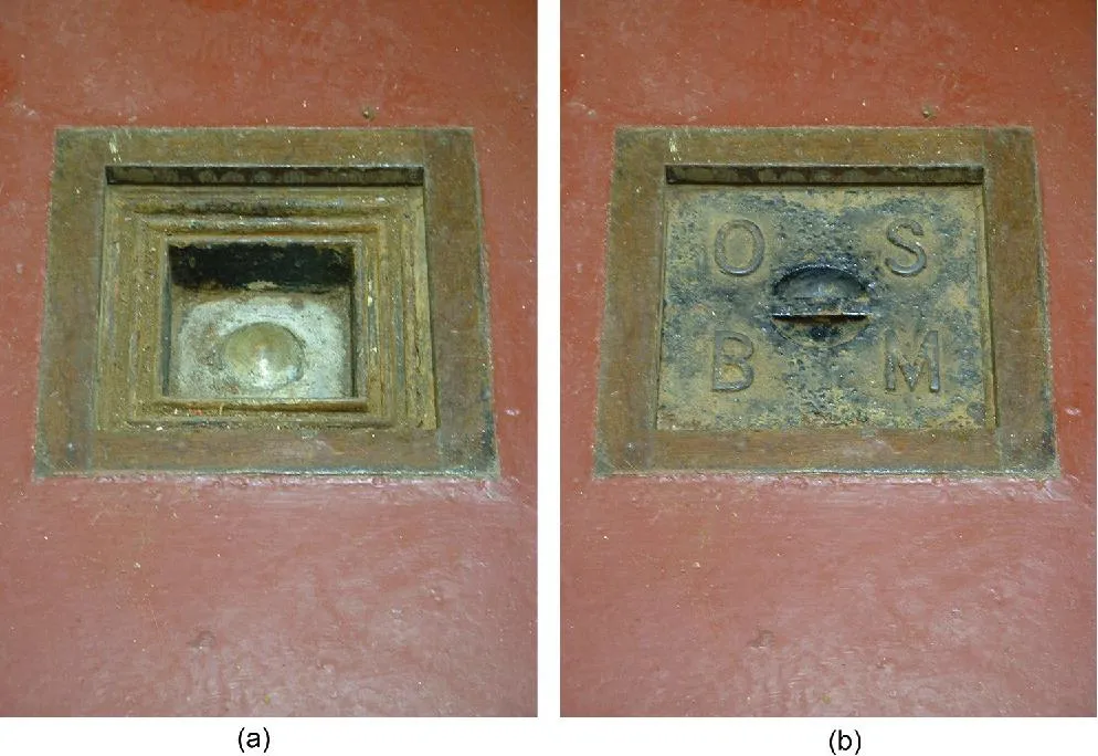
(a) The brass bolt benchmark (OS BM 4676 2855) which is located in the Tidal Observatory and from which the ODN national datum is defined as being 4.751 m below the mark, and (b) the cover of the historic mark. Copyright details can be found at the end of this blog.
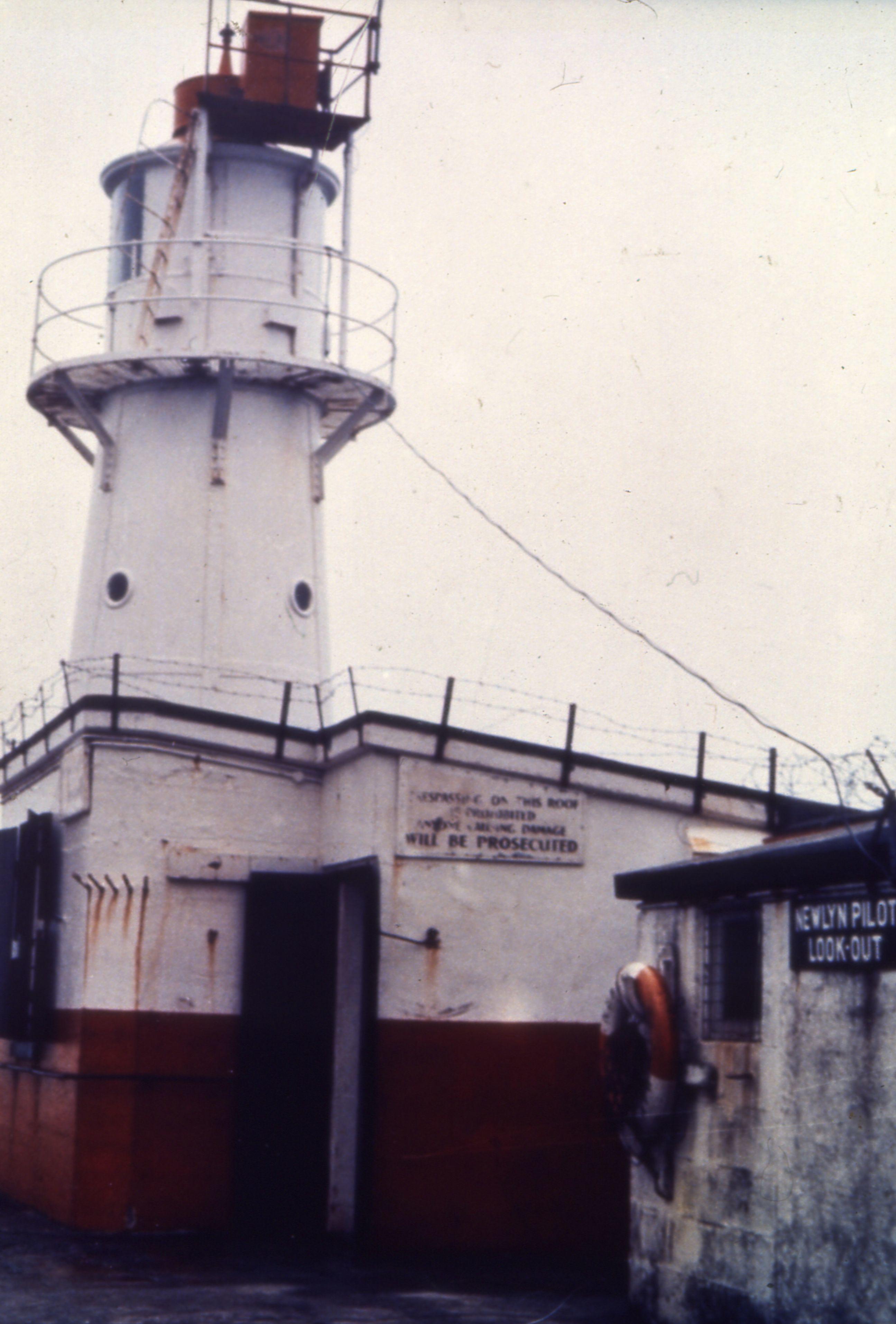
Newlyn Tidal Observatory
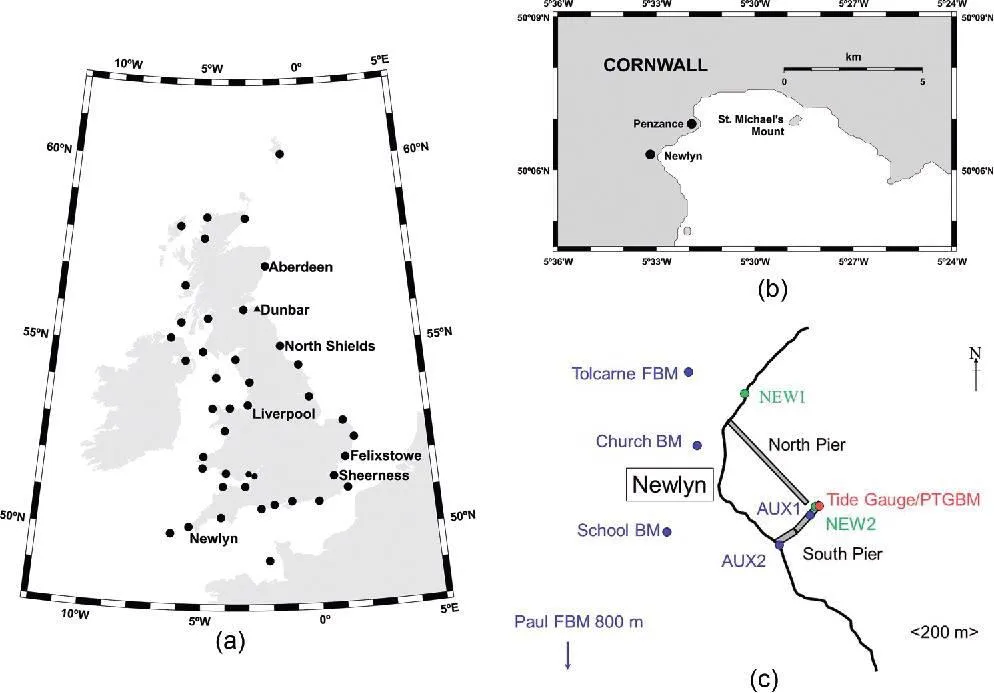
Although OS set up tide gauges in Felixstowe (1913), Newlyn (1915) and Dunbar (1917), Newlyn was chosen as the single reference datum. This was largely because it's in an area of stable granite rock and, with the gauge at the end of a stone pier at the harbour entrance, it's exposed to the open Atlantic. This location meant it wasn't likely to be influenced by the silting up of the estuary or river tide delays.
OS monitored the tide gauge at Newlyn, along with some 29 other tide gauges, until 31 December 1983 when the responsibility of all tidal observations was transferred to the Natural Environment Research Council (NERC). Tide gauges are now the responsibility of the Environment Agency, who use them to monitor rivers and flood water levels.
The Newlyn Tidal Observatory was manned continuously since its construction until the early 21st century, only once being out of reach for tidal observers during the worst storm ever to hit Newlyn in 1962. At the end of 2018, the Newlyn Tidal Observatory was declared a Grade II listed building by Historic England.
Height data today
It’s been one hundred years since the measurement of mean sea level at Newlyn, during which time the importance of height data has only increased.
From emergency responders knowing which equipment to deploy to architects visualising designs, height data is relied on by many organisations. It’s also used by sustainable energy companies locating the optimum positions for solar panels and wind turbines, companies managing overhead cable routing, flood modelling, and by mobile phone networks for signal propagation with the positioning of masts.
From the contour lines in OS Explorer and OS Landranger maps to the popular 3D fly through feature in OS Maps, outdoor enthusiasts also rely on height data when exploring the mountains and hills across Great Britain.
The history of the tide gauge at Newlyn reveals the fascinating evolution of levelling - find out more.
BBC News takes a look at the Cornish hut that gave rise to sea level benchmark - read more.
Thank you to Taylor & Francis Online for some of their amazing images. Discover them yourself via their website.
Copyright details for Taylor & Francis Online images.
This is an open access article distributed under the terms of the Creative Commons CC BY license, which permits unrestricted use, distribution, reproduction in any medium, provided the original work is properly cited. You are not required to obtain permission to reuse this article in part or whole. This is an Open Access article distributed under the terms of the Creative Commons Attribution License (http://creativecommons.org/licenses/by/4.0/), which permits unrestricted use, distribution, and reproduction in any medium, provided the original work is properly cited.
Sharing the latest news about OS. We can license you to use OS maps in print, online and film format. For more information and resources for journalists, bloggers and media professionals, email pressoffice@os.uk or call 023 8005 5565.
Find more blog articles
- OS
- General public
- Great Britain
- United Kingdom