The geography of Britain’s high streets
Today the BBC is reporting how Covid-19 has impacted high streets across Great Britain. To support its story, the BBC has used Ordnance Survey (OS) data, including two new experimental datasets. Iain Goodwin, Strategic Development Manager in the Government Relations team at OS has worked on this from the outset and talks us through this new data, including the rationale, what it has taught us and the potential impact it might have.
What is a high street?
Everyone knows what a high street is, don’t they? When you’re out shopping, it can appear easy to define a high street and where it starts and ends. But is it that simple? Can a town have more than one high street or is the road called high street in your town still the primary shopping area?
Over the last few years OS has been working with the Office for National Statistics (ONS) to support the public sector by defining and analysing Britain’s high streets. Together, we have been working out how many high streets there are in Great Britain, what types of properties and businesses are on high streets, as well how the number of businesses and employment has changed in recent years.
The following analysis was only made possible thanks to the vast amount of trustworthy data available. As the national mapping service of Great Britain, OS presides over the largest and most authoritative geospatial database in the world. Since 1791 OS has captured and maintained this database which now contains over half a billion geographic features, 247,800 miles of road and over 40 million addresses. All of this is updated over 20,000 times a day.
But with all that data available, where do you even start? Well, given that no definition of high streets existed before this project commenced, this seemed like the natural starting point. We think of a high street as a location that people visit to shop, eat and drink, which we classify as ‘retail’. We looked for all addresses classified under retail within our AddressBase Plus dataset. From there, we wanted to understand streets with clusters of retail addresses.
We then created algorithms to decide what a cluster is. To avoid naming small rows of shops as ‘high streets’, and to keep the data clean, we decided that a minimum of 15 retail addresses would be required to create a high street, provided they are within 150 metres of each other.
By using this spatial cluster analysis – in conjunction with street names – we’ve been able to create linear (straight line) clusters along a high street rather than sprawling clusters like retail parks, industrial estates and isolated shopping centres.
However, user feedback asked us to expand our definition to describe a more complete view of retail clusters, including smaller rural high streets, shopping centres and retail parks. This informed the second iteration of the data used by BBC in their analysis, namely Retail Geographies. But more on that later.
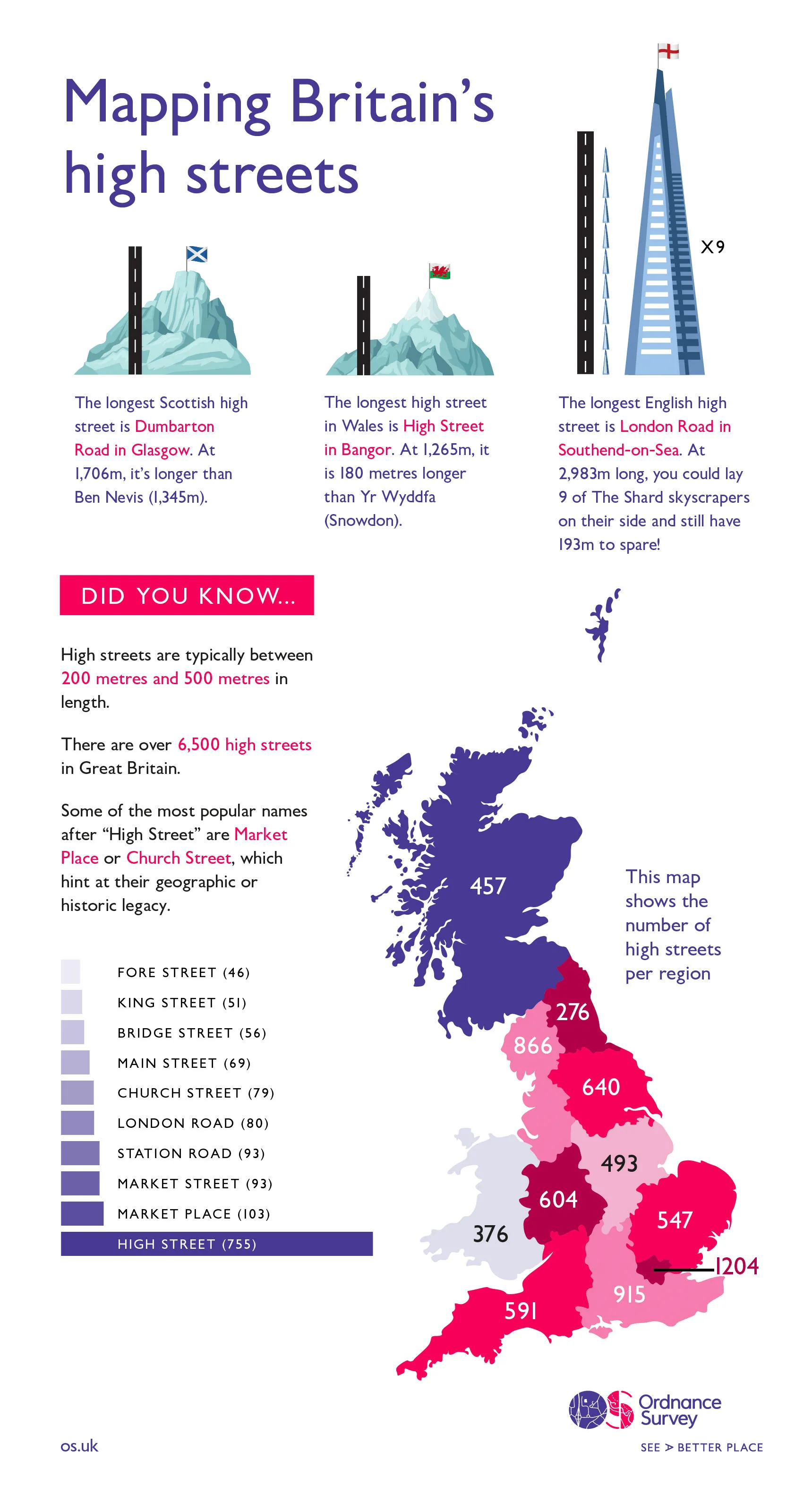
As the infographic illustrates, outside of London and the southeast, the northwest has the longest length of high streets, almost three and a half times the length of high streets in the northeast. However, the fact that the definition uses a minimum retail address threshold means that some traditional high streets which are locally important may not be captured. For example, there is no high street visible for Hugh Town on the Isles of Scilly because the density of the retailing does not meet the criteria we have defined.
Therefore, we decided not to make a manual intervention to include any shopping street here, as this would make the classification incomparable across other similar areas, such as for some islands in Scotland.
Likewise, a small selection of what locals might consider to be high streets are not captured in cathedral cities, like Norwich. In this case, reworking the methodology to automatically capture the streets results in the inclusion of many smaller geographies that do not meet the general expectation of a high street definition.
There may be other exceptions, or indeed inclusions, that local people find unexpected; but this is very much a live project, and we will see changes and improvements over time.
Evolution to Retail Geographies
As we briefly mentioned earlier, user feedback asked us to expand our definition to provide a complete picture of retail across the nation. Non-linear retail clusters have now been incorporated into a new dataset called Retail Geographies. This, more comprehensive dataset, has evolved beyond high streets to include retail parks and shopping centres and now provides a wide-ranging overview of the retail of the nation.
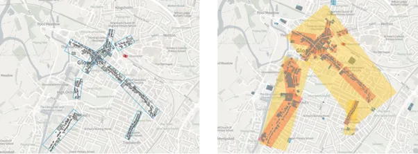
The above image of Gloucester clearly illustrates the difference between the High Streets dataset (left) and the Retail Geographies dataset (right). Retail Geographies captures everything from local parades and rural highstreets to shopping centres and central shopping districts.
Have these experimental datasets had a real-world impact?
Aside from the main project of defining what a high street actually is, our experimental data has proved valuable for many institutions including central government, councils, academia and the Police, especially in combatting Covid-19.
Richard Prothero, Head of the Centre for Subnational Analysis at ONS, said: “ONS has supported the development of the Retail Geographies dataset by OS as it provides a range of new options for the reporting of regional and local statistics.
“In particular it will help examine topics such as changes in the retail industry and the future of high streets and town centres. ONS plan to use the geographies combined with our statistics in new outputs in 2023.”
Reviving towns and high streets is a key government priority after the significant economic impact of Covid-19, with high streets already feeling the effects of increased competition from online retailers.
Each area has different assets and its own unique opportunities. Now 7,000 high streets have been defined and linked to socio-economic data from ONS, this project has helped provide new insights about local needs. This will help underpin the monitoring and evaluation of the Future High Streets Fund, the Towns Fund, Heritage Action Zone Funds, the Coastal Communities Fund and wider regeneration work that will need to take place to manage the local impacts of Covid-19.
Thanks to this experimental dataset, the police have now been able to link information on robbery locations to high streets to better inform geographical tasking of resources to tackle retail crime in our city centres.
Councils have used this data to understand how different communities are responding to Covid by mapping Covid cases and analysing the relationship with local businesses, deprivation and the demographic make-up of the local areas. By linking this to third party population classifications and pay information, they have been able to profile areas to inform policy development which has aided local recovery and informed local leadership.
Moreover, councils have analysed defined areas of retail as potential high contact settings in support of Covid response work, which have helped identify areas of common exposure and identified potential surge testing sites.
In academia this data has proved valuable and allowed academics to explore:
- the transformation of public spaces in the post-Covid period by analysing changes to human behaviour using street networks
- the functional similarity among Britain’s high streets by linking Points of Interest data to create attributes such as high street rank, economic performance and local demographics
- the relationship between proximity to high streets and greenspaces and loneliness and social isolation in young people.
We are continuing to work with the ONS to further develop these experimental datasets as well as allowing selected PSGA members to continue to carry out real-world testing against the challenges they are facing. But from tackling Covid-19 and improving the efficiency in police resources to helping understand potential social isolation in young people, our high street and retail geographies datasets are proving valuable already.
High Streets is an experimental OS dataset describing the spatial extent of high streets across Great Britain. The dataset is a high street specific providing a street level definition. It bounds retail clusters using street naming and deliberately excludes other retail function including retail parks and isolated shopping centres.
Retail Geographies is an experimental OS dataset describing the spatial extent of retail functions across Great Britain. The dataset bounds retail clusters using street naming and includes all retail functions from high streets to retail parks and shopping centres.
Strategic Development Manager
Iain Goodwin is a Strategic Development Manager in the Government Relations team at Ordnance Survey.
Sign up for PSGA updates
We’ll keep you up to date with
- The PSGA newsletter
- Member events
- PSGA webinars
- OS products and services
Find more Insights
- Products and services
- PSGA members
- Government and public sector
- Great Britain