OS Postcodes: a smarter view of Britain’s postcode geography
Tom Peterken, Data Scientist, and Laura Gribble, Product Manager at Ordnance Survey, explore how the new OS Postcodes dataset can unlock deeper analysis
Postcodes are a small but powerful piece of everyday life, playing their part in deliveries, service areas, underpinning analysis, election boundaries, and connecting millions of addresses every day.
Following the release of OS Postcodes, we decided to explore possibilities; whether we could use postcodes to answer new, specific questions, such as:
- Which postcode contains the most properties?
- Where do postcodes cover more residential or commercial uses?
- Where are the biggest/smallest/roundest postcodes?
OS Postcodes is our new postcode data, built for deeper analysis, richer context, and easier connection with the rest of the OS National Geographic Database (NGD). That means you can now combine improved geometries with clearer connections to postal areas, districts and sectors, as well as addresses, buildings, and land cover.
Largest to smallest
OS Postcodes opens up a far richer view of Britain, and it has revealed some genuinely surprising facts along the way!
Take size, for example. Some postcode sectors contain hundreds of individual postcodes, while others contain just one. In theory, a sector could hold 676 – and although none have reached that limit yet, some urban sectors are already well into the hundreds.
At the other end of the scale, several postcode districts contain only a single postcode – often “Large User” postcodes assigned to major organisations.
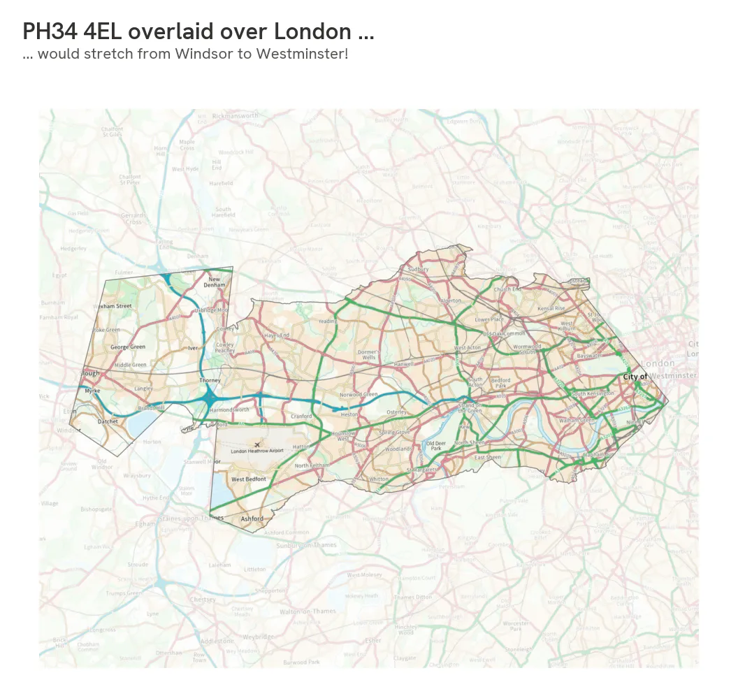
When it comes to sheer size, the largest individual postcodes are all in rural Scotland – one of them, PH34 4EL, stretches 34km east to west. If we dropped that sector over London, it would stretch from Windsor, all the way to Westminster!
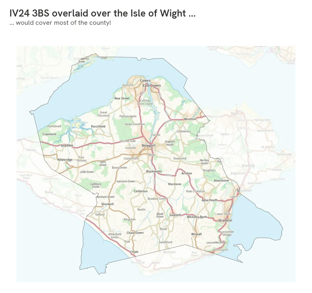
While experimenting like this, we also used another Scotland postcode, IV24 3BS, which is so large it almost covers the entire Isle of Wight:
Meanwhile, some postcodes are very small. A handful cover just one building, including arcades in Cardiff and Mayfair – and the smallest of all forms part of Christ Church, University of Oxford.
Shapes
With improved postcode geometries, OS Postcodes also lets us explore shape as well as size. This led to some more interesting questions, such as: what’s the roundest postcode in Great Britain?
Two of the most circular postcodes sit neatly inside parks: Regent’s Park in London, and Bedford Park in Bedford. Others include sites like Durham University’s Mount Oswald Hub, and the British Museum.
Elsewhere, some postcode sectors are almost perfectly square, like the Purley Sorting Office in South Croydon, while others form triangles, including one covering Salford Quays.
More importantly, these improved shapes follow real‑world features far more accurately.
Older postcode data can make boundaries simplified. OS Postcodes follows the real world much more closely: coastlines, rivers, parks, and estates all shape the geometry. That means any analysis based on area, density, or coverage is now much more reliable.
Addresses
OS Postcodes explicitly links delivery points and addresses, and when we integrate the two, an entirely new layer of insight appears. We can start to understand the character of places.
For example, the least dense districts are all in rural Scotland. One postcode district covers the Isle of Rum, home to around 30 permanent residents. Perhaps unsurprisingly, the most address‑dense postcode districts sit in central London, in places like Canary Wharf, Hatton Garden, and Finsbury, where commercial and residential building-use overlap.
OS Postcodes can show whether areas are mostly commercial or residential, which is how we started to notice expected patterns in central London, for example, and perhaps more surprisingly Shetland’s fishing and oil industries.
A richer postcode picture
OS Postcodes doesn’t just tell you where a postcode is. It also shows how postcode units relate to:
- Postcode areas, districts and sectors
- Addresses and delivery points
- Buildings, land use, and geography
- The British National Grid
Because OS Postcodes is part of the National Geographic Database, it connects effortlessly with other datasets.
Link it to OS Buildings and you can see where the UK’s oldest housing stock is concentrated (largely in London), where construction is still accelerating on urban fringes, and which districts have high proportions of derelict buildings.
Bring in OS Land Cover, and entirely new questions emerge: which postcodes are wetter than Cardiff Bay, more wooded than much of Surrey, more agricultural than anywhere else in England, or dominated by suburban gardens?
All of this is possible because OS Postcodes has been built for analysis, not just reference. The data is more structured, the geometries are more realistic, and the relationships between postcode levels are explicit and easy to aggregate and work with.
Built for what comes next
If postcodes play any role in your organisation’s workflows, services or analytics, now is the time to start exploring. OS Postcodes opens a whole new way to understand places and their character, and unlock new layers of actionable insight.
In addition, OS’s existing suite of Code-Point postcode products will be withdrawn in March 2028. Migrating to OS Postcodes will provide ample time to adapt, and the opportunity to unlock even more value along the way.
Whether you’re answering queries, building new services (or just curious to see the biggest, smallest, roundest, squarest, and wettest postcodes in Britain) start exploring OS Postcodes.
You can try linking it with other NGD datasets, and begin planning your migration well ahead of 2028.
Click below to try out our OS Postcodes sample data:

Our highly accurate geospatial data and printed maps help individuals, governments and companies to understand the world, both in Britain and overseas.
Try this product with free sample data
Download a small area of OS GB Postcodes. Or try out the real thing by applying for a Data Exploration Licence.
Products and solutions featured in this insight
OS GB Postcodes
OS GB Postcodes provides a consistent view of postcode geography that aligns to real-world buildings and streets across Great Britain.
OS NI Postcodes
OS NI Postcodes provides a consistent view of postcode geography across Northern Ireland.
OS Building Features
Access data on buildings and building features, including building heights, lines, and access points, across Great Britain.
OS Enhanced Land Cover (Beta)
An aggregate of OS data, third-party land cover, and ecological datasets to assess and monitor land cover of the natural habitats within England.
Find more Insights
- Products and services
- Partners
- Businesses
- PSGA members